Friday, February 24, 2023

(Whoops) Omelet emergency: Bird-flu problem ctd.


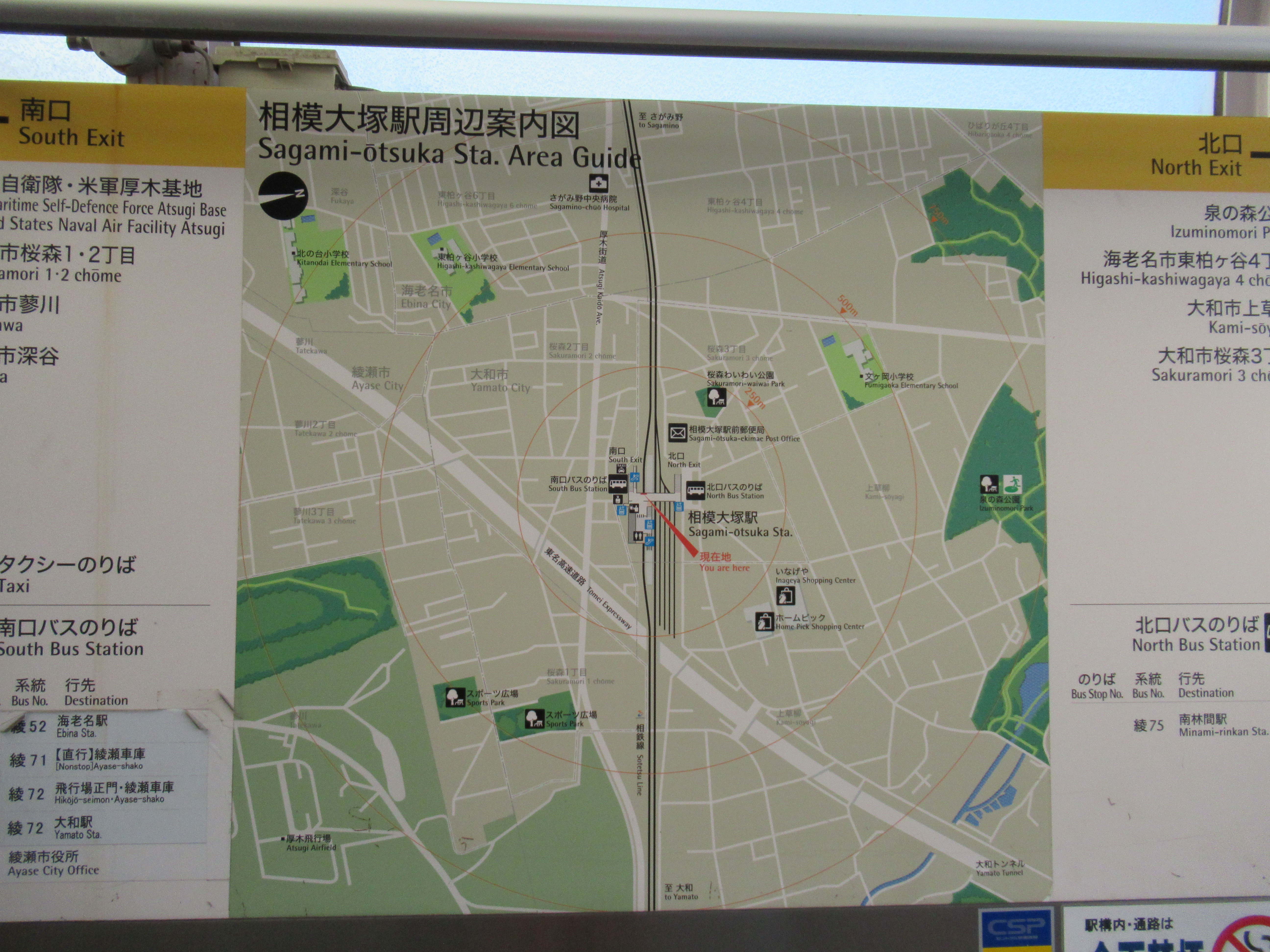
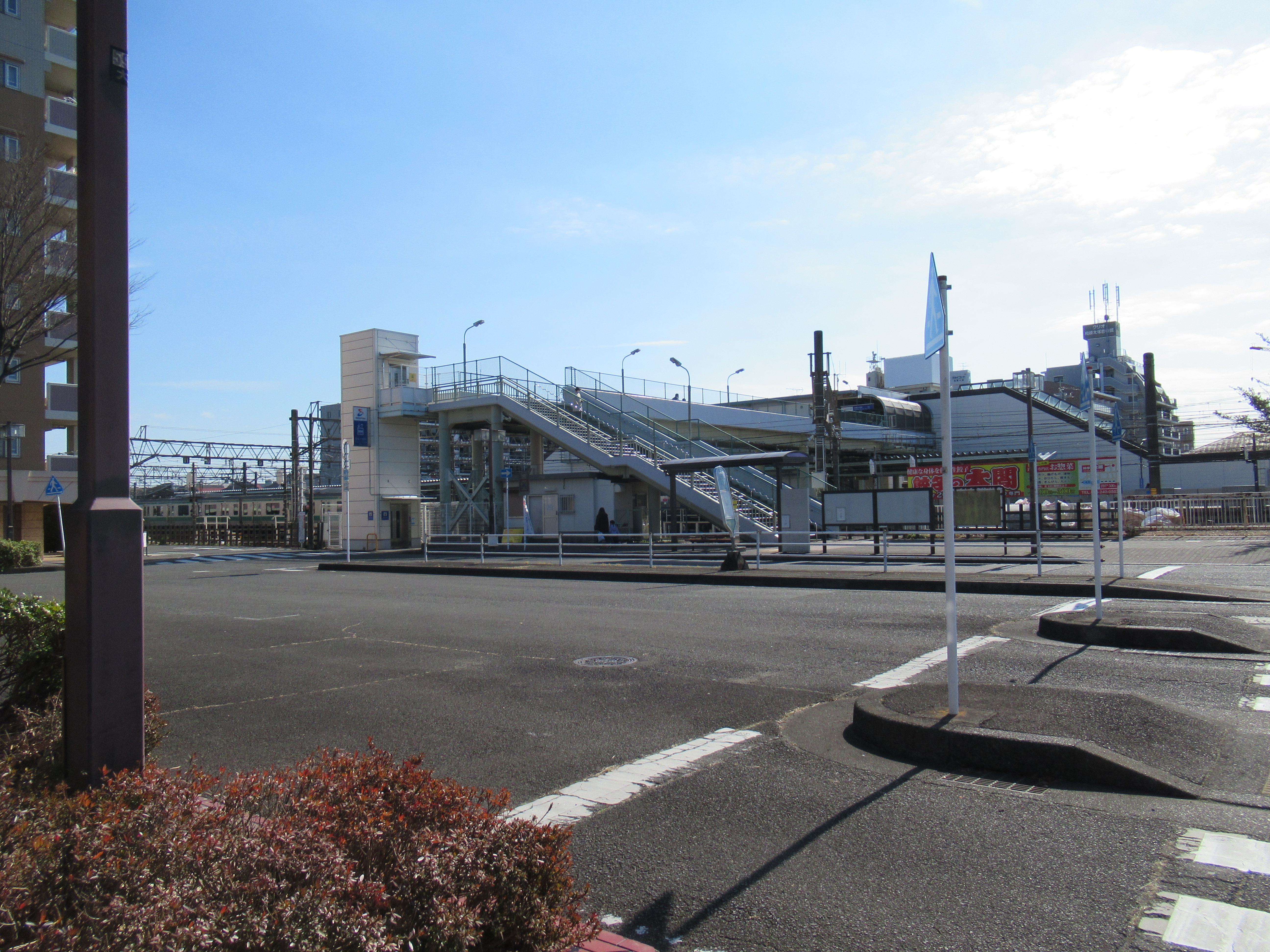
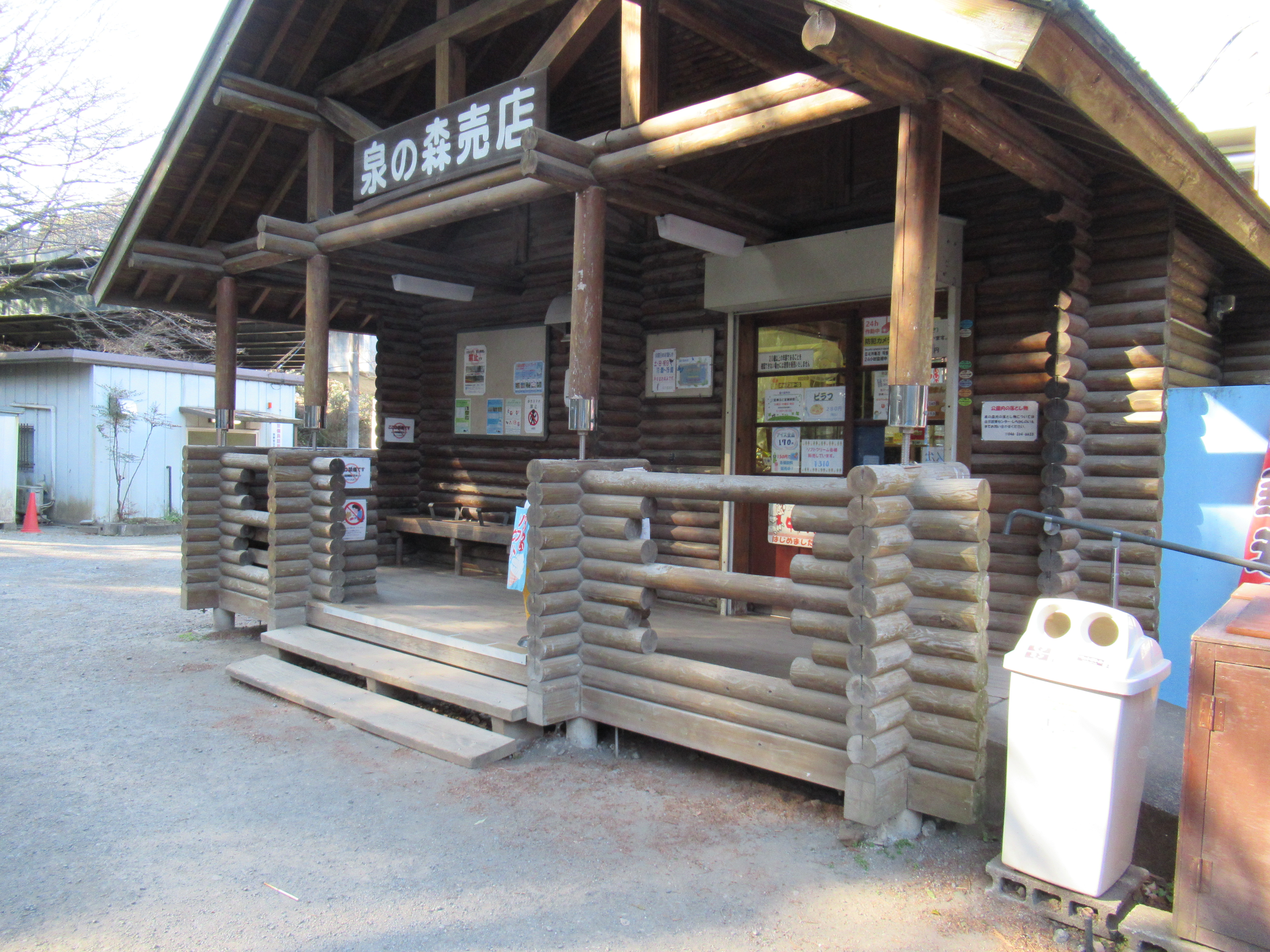
I planned to continue telling my adventure with DNA monitoring this week, but the bird-flu thing (my post on January 13 and January 27) and has come very near to our table. So, I show you the below photo for this week.


You see? No egg for supermarkets in Yokohama now. Lots of chicken were infected, and so died or killed … we have omelet-emergency every morning … Please take care wherever you are. Does your breakfast go peacefully?

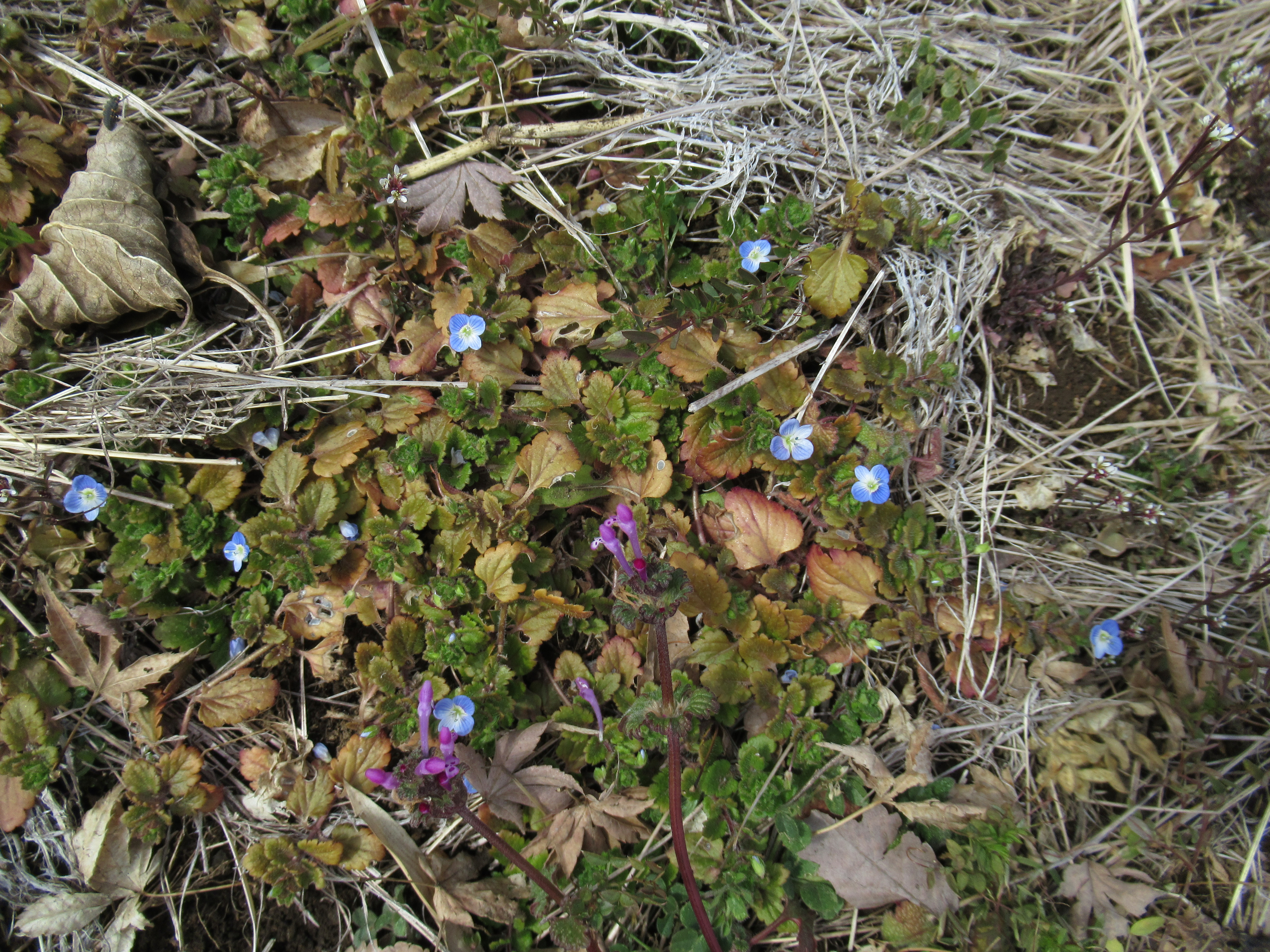
Spring is coming ...

If you find environmental issues in Kanagawa Prefecture, please make a contact with Kanagawa Natural Environment Conservation Center 神奈川県自然環境保全センター

657 Nanasawa, Atsugi City, 243-0121
〒243-0121 厚木市七沢657
Phone: 046-248-0323

You can send an enquiry to them by clicking the bottom line of their homepage at http://www.pref.kanagawa.jp/div/1644/

Friday, February 17, 2023

Biodiversity at gene level; DNA sampling for water quality monitoring in Kanagawa Prefecture, 1


Since last year, I listed myself as a citizen monitor for the water quality of Kanagawa‘s rivers. They supply tap water to us living in Kanagawa (; my 5 consecutive posts from October 21 to November18, and one for 30 December). Our main approach for the task is good-ol‘ nature observation, sometimes with lab study with stereo microscopes. The method has its history starting 2007. It has accumulated data for biodiversity of the river environment and its surrounding forests and towns. Of course, it has limitation. Aside from familiar man-power or the like problems, there is inevitable difficulty to check wild habitat by humans. Not every point of earth is easy for homo sapience to go near, even if it‘s with simple landing nets and vats.

What‘s there?

Say, you walk in Tanzawa mountains and try to collect specimens of aquatic creatures for water monitoring. You encounter an almost vertical fall of stream. It has large and extremly slippery stone wall. The wall looks suspiciously rich for water lifes. They could cling to moss-eaten rock 5m high above from our narrow and precarious trecking route. CAUTION: don‘t try to collect specimen from such dangerous part of water flow. Or, below your feet on a simple mountain bridge, some 20m below, there is a waterfall basin. With binoculars we recognize fishes down there. But fishing from narrow and unstable mountain crossing cannot guarantee you a catch … CAUTION: don’t try to collect specimen from such dangerous part of water flow. You got the point, don’t you? Don’t worry. There is a possible solution for studying ecosystem of this kind of environment, thanks to the 21st century technology. It’s DNA sampling.

DNA sampling demonstration

Originally, the method of using DNA for cataloguing water creatures was started to study ocean. Well, no one expects humans to study comprehensively the entire sea of this planet. On the other hand, all the living things shed and spread the remnants of gene within the environment. Majority of us wash away our dirt peeled from the body in regular shower, or using toilet, don‘t we? It means our body accumulates and discards old body parts made by gene everytime. (er ... it sounds ... yack. But let‘s face the reality!) Same is happening for the water dwellers. Living or dead, they continuously leave the traces of their gene, aka DNA, in water they live. Scientists noticed this, and develped the way to collect DNA from a bucket of sea and the other natural waters. They feed the DNA data from water to powerful computer and analyze the result. Starting this fiscal year, Kanagawa Prefecture introduced this way of monitoring water quality by citizen monitors ... For more detail of the project scheme, I tell you later. This post and next are for my adventure with actual DNA collecting in Yadoriki Water Source Forest やどりき水源林.

Pacific Ocean!

Kanagawa‘s way to collect DNA from rivers has two approaches. One is using syringes. Another is literly collecting a bucket of water. For both approaches once the sample is taken, they must be at least cilled or frozen. Monitors must rush to a courier’s office to send it to the Prefecture’s lab by express. I realized, yeah DNA is ubiquitous in natural water but they are very fragile. DNA is broken apart quickly unless treated carefully. That’s the reason why there is no “DNA pollution” of river, lake, pond, sea, … Come to think of it, it would be why the ecosystem is happy to accept “natural” garbage and circulate everything in a sustainable way ... Anyway, let me show you what kind of thing we’ve done this fiscal year for DNA sampling. Let’s start with the syringe method. Here is a kit I received from the lab of the Prefecture.


The first thing we monitors must do is to wear gloves before collecting water. In the same token, we’re to stand downstream, when we collect water in a stream. It’s to avoid contamination. Researchers don’t need human DNA in the sample, you know.

Wearing rubber gloves

Or, standing downstream.

Next, a usage of bucket. Unlike oceanic study, we don’t need a large bucket to collect water. So, a plastic cup in a size of coffee mag is enough. I attached a rope to it in order to collect water from a point where we cannot have direct access, like a waterfall basin. Throwing the “mag” and pulling the string toward us would do the job. Also, we have to sanitize it before usage with dishwashing liquid, dry it under sunshine completely, then rinse the cup just before collecting sample with the same natural water from which we collect water.

A washed cup with a rope attached.

With it, we can collect water from a point like this, or

From a waterfall basin like this.

For syringe method, 50ml of collected water is sucked up into a syringe from a cup and discard the remaining water downstream. At the tip of the tool, we attach a Sterivex that is a filter to catch DNA. We push water from a syringe through the filter. Once 50ml is filtered, we repeat the same process until we draw1000m through the filter. But it is often the case we cannot filtrate 1000ml as the pump of syringe reaches to the point where it cannot go any further. Inorganic material like dust? Some other things? Very large DNA? We stop the process at this point, and record how much water we filtered for the Sterivex.


A syringe with Sterivex.
The amount of water is for one cycle.

Filtering ...

Once the filtering reaches to the max, we pump it for the last with air and squeez any remaining water inside the Sterivex. Mr. Hasebe of Prefecture told us, “This is VERY IMPORTANT process to preserve DNA!“ Then, remove the Sterivex from the syringe and seal the tip with a rubber cap securely.


We then pour 2mL of RNAlater in the Sterivex with a sterilized dropper. It‘s to suppress the break-down of DNA. Once all the RNAlater is added, close the end of Sterivex tightly, like this.


The next step must be taken quickly. We enclose the DNA sample filter in a cooler bag with frozen ice packs, and send it in prompt as a “frozen matter” from the nearest courier office. If the preservation of DNA goes OK with RNAlater and frozen packs, the DNA can reach the freezer of the Prefecture office in no time and the sample can be kept for a long period as long as the freezer works OK. Some people said the process is very tedious, but I found it very interesting. Actually the most difficult part of the task was to reach to the courier office smoothly (because traffic jam, etc.) and to send the sample as “water filter,” not a biological matter … sending biological or medical thing as courier is EXTREMELY difficult in Japan, of course ... I think I don’t tell a lie at the courier … It’s filtered water, to be sure. Phew! Next week, I tell you the “bucket method,” and more about the adventure of dipping up water in Yadoriki Water Source Forest for DNA. Please stay tuned!


If you find environmental issues in waters of Kanagawa Prefecture, please make a contact with Kanagawa Environmental Research Center 神奈川県環境科学センター

1-3-39 Shinomiya, Hiratsuka City, 254-0014
〒254-0014平塚市四之宮1-3-39
Phone: 0463-24-3311
FAX: 0463-24-3300

k-center@k-erc.pref.kanagawa.jp

https://www.pref.kanagawa.jp/docs/b4f/index.html

Friday, February 10, 2023

Everybody Loves Green Parks: Izumino-mori Forest and Hikichi River 泉の森と引地川


This week, I’ll tell you my adventure in Izumi-no-mori Forest 泉の森, which is the source for microplastic floating Hikichi River 引地川 (; my post last week). For the sake of honor for Izumi-no-mori Forest, the microplastics we find in the downstream of the River is not necessarily started at the source. Rather, the main culprit would be the environment the river runs in. Telling you the truth, until I visited Izumi-no-mori Forest, I did not think Naval Air Facility Atsugi, the US Navy’s base camp, is very near, actually about 1km south to, the Forest. Hikichi River runs sometimes eastern edge of the Camp. I know Americans love astroturf … Anyway, I found plastic garbage already floating in Hikichi River at the exit of the Forest. Everybody should be aware of the result of such casual trashing of the environment, I presume.

Plastics floating outside Izumi-no-mori Forest

So, the nearest public transport facility going to Izumi-no-mori Forest is the same for Naval Air Facility Atsugi, which is Sagami-Otsuka Station 相模大塚 of Sotetsu Line. Tsuruma Station 鶴間 and Yamato Stations 大和 of Odakyu / Sotetsu Lines are also in walking distance to the Forest. In addition, Izumi-no-mori Forest spreads to both sides of Route 246 (; my post on March 17, 2017). The southern edge of the Forest is Tomei Express Way. As the place has ample car parking spaces, you can drive to the Forest and enjoy a relaxed stroll there. On foot, the access from Sagami-Otsuka Station is nearest. Let’s take this route. Simplest would be leaving the station from the north exit, and keep to the north in suburbia of ordinary houses. The distance between the Sagami-Otsuka Station and the Forest is not much, about 500m. The Forest is large so that you eventually bump into the edge of it even if the point you reach does not have a road into the forest. When you reach the forest rim, just walk along the road between the forest and the houses. You’ll meet the First or Second Parking for the Forest. Welcome to Izumi-no-mori Forest!

The map of the area shown
outside of the ticket gate of Sagami-Otsuka Station.
 The station is in the center of this map.
 Southwest corner is  Naval Air Facility Atsugi,
 and Northeast corner is Izumi-no-mori.
The north exit of Sagami-Otsuka Station
Outside the station,
there is this map for Izumi-no-mori Forest.
 We can use this map to the forest.

Eventually, we reach the rim of the forest like this.

The Second Parking

The larger First Parking

Though its name does not contain “park,” Izumi-no-mori Forest has the design similar to city parks such as Shiki-no-mori Park 四季の森公園 (; my post on June 26, 2020), Takane-Park 高根公園 (my post on June 15, 2018), and Yokohama Children’s Amusement - Botanical Park 横浜子供遊園地・植物園 (; my post on November 4, 2016). Many routes in Izumi-no-mori Forest are wide enough and relatively flat so that wheelchair users could enjoy nature as well. The entire land for the forest is lent indefinitely by landlords to Yamato City 大和市. So, visitors are expected to “behave” in a private property. Beyond the parking space, there are two old traditional houses that serve as historical museums of Yamato City. Both houses were transferred from the other part of the City in order to preserve them as heritage sites. One is the house of Ogawa Family that was built during the first half of the 18th century. Another is the house of Kitajima Family built in the early 19th century. By visiting these two houses, we can know the 100 years has made difference in the design of the house. The newer Kitajima house has a more robust structure, and equipped with spaces for sericulture. Sericulture and silk were the main industries for the early industrial revolution in Japan. The contrast between these two houses could say the process of economic development of Japan during the industrialization. Beyond the museum area, there is a BBQ space which has the larger First Parking. Especially after COVID, the place became very popular. Many people enjoy casual outdoor parties there these days. RSVP (; for details, here).

The house of Ogawa Family

The house of Kitajima Family

The BBQ place

Northwest of the Forest, beyond Route 246 is the area for the water source of Hikichi River. We can visit there from the BBQ place. Go down the road from the BBQ place and in front of us is a valley that runs beneath the flyover of Rote 246. The pedestrian routes go along the valley, and we can find two ponds almost immediately beyond the overpass. The ponds are actually springs. The area around the ponds and the small stream from it are off limit, sealed off by wire fences. Kanagawa Water Supply Authority oversees management and preservation of the place, since until 1992 the place supplied tap water to about 1900 households surrounding the north part of the Forest. Now the water from the Forest does not enter the water supply system as Sagami and Sakawa Rivers do the enough job for the area. Compared to the Southwest part of the Forest, this side is “deep” forest. Though, many broadleaved trees were affected by Oak Tree Wilt and some were on the verge of falling. The management of the Forest sealed off many strolling paths in order to prevent fatal accidents (; my post on August 23, 2019). Please follow the warning signs when you walk there. Those trees are large, and your cranium can easily be flattened when they come down over your head!

To the under-overpass

Under 246 is like a playground for kids.

The road is in general wide
and well-maintained inside the forest.

There is birdwatching station for observing birds
 coming to the water source pond.

The water sources are sealed off.

And a grey heron relaxed near the pond
… do we call it as “he’s in a cage”?

Southeast side of the 246 overpass starts with an area that has the administration cottage (“Shirakashi-no-ie”), a small shop, a police station, and a restored water mill. From the admin office, you can have a hardcopy of the map for the forest. The place also serves as a mini nature museum giving us information about the biosphere of the forest and the surrounding area. It also has the latest news from volunteer organizations that help the management of Izumi-no-mori Forest. If you’re living near there and interested in fieldworks for the forest and the stream, you can find info how to join them, etc. Oh, one important thing. Izumi-no-mori Forest equips toilets here and there, but the area surrounding the admin office has the largest numbers of it. Don’t miss your chance.

A shop and a police station

An admin-cum-museum cottage

Inside of the cottage is like this.

Water mill

In front of the admin area are landscaped streams that lead water from the source to Hikichi River. They have nice semi-paved promenades along the streams where lots of families have a leisurely walk for sunny weekends. The very end of this landscaped stream is a pond named “Bamboo-leaf oak Pond.” The place serves as a regulating reservoir to prevent flood from Hikichi River. It is allowed to fish there provided you don’t do lure fishing. During winter we can find lots of migratory winter birds floating on the pond. The place is famous for amateur photographers of wild birds. During winter they jostle each other for the best position for their perfect shot of mallards et al. The pond ends with a overflow dyke that is also the end of Izumi-no-mori Forest. Beyond the dyke is Hikichi River.

They built this nice suspension bridge
 over the landscaped stream.

Many people enjoyed the waterside.

And a row of photographers focusing on …

Eurasian Pigeon.

Great Cornmorants were also there.


The dyke which is the end of Izumi-no-mori Forest.

The southwest embankment of the dyke, there is a small forest of bamboo-leaf oaks (Quercus myrsinifolia). The place is considered to be a few remaining climax forest for Sagamino Plateau 相模野台地. Sagamino Plateau is a geological area sandwiched between Sagami River and Sakai River 境川 (; my post on January 28, 2022), ended around the border between Yamato and Fujisawa Cities. The plateau did not have good water sources for human consumption. During pre-industrialization people did farming on the Plateau, not rice cultivation, which was at that time an implicit sign of “poverty.” In the climate for Sagamino Plateau, the climax forest should be dominated by evergreen bamboo-leaf oak but people cut them off for their more convenient trees. They afforested their hills with sawtooth oaks, jolcham oaks, and coniferous trees. These oaks became good charcoal, the main fuel for people before imported oil dominated the economy. Their leaves supplied good compost for tobacco cultivation, the main cash crops during the period. Coniferous trees were sold for housing materials. Not many naturally climax forest remain now on Sagamino Plateau. The forest in Izumi-no-mori is a rare remnant of natural forest before people used intensively their land for their livelihood. (I won’t say it’s a virgin forest. Who knows if it has never experienced human intervention!) Kanagawa Prefecture designate the place as Prefecture’s Natural Treasure that should be protected “as is.”

Natural Treasure of the Prefecture

… looks ordinary, but …

Leave the dyke and walk the promenade along Hikichi River, we proceed under the flyover of Tomei Expressway, and enter “Fureai-no-mori ふれあいの森” which is a landscaped city park along Hikichi River. The end of Fureai-no-mori is almost the beginning of the main pedestrian way to Yamato Station. The other fine weekend when I took this route, the Forest, especially around the admin office to the Park and Yamato Station, welcomed many families and groups of friends. I even had a feel of “congestion.” The greenery and riverside are loved by locals quite a lot ... The reason why such seemingly ordinary forest of bamboo-leaf oaks is designated Natural Treasure is the area’s historical difficulty for the access of water sources. The scarcity of water, together with its location relatively near to Tokyo and Yokohama, made secretly unique the area of Sagamino Plateau and Hikichi River. Why does Hikichi River run through housing suburbs, and Naval Air Facility Atsugi? Why does the place not have many deep forests, compared even to Yokohama? And why does Hikichi River let microplastics float that much? Peaceful rows of family houses carry old, and contemporary, burdens, but in any case, we all love quiet strolls in the forest and along the river ... Oh, in some corners of Japan, people have started to discuss lawmaking to prohibit usage of astroturf, in order to stop microplastic contamination getting worse. The new chapter for Izumi-no-mori Forest and Hikichi River may start not before long.

To Fureai-no-mori

Under the Tomei Expressway is like this.

Brown-eared Bulbul were neatly drinking from Hikichi River.

Fureai-no-mori

There are signs showing us the direction to Yamato Station.

If you find environmental issues in Kanagawa Prefecture, please make a contact with Kanagawa Natural Environment Conservation Center 神奈川県自然環境保全センター

657 Nanasawa, Atsugi City, 243-0121
〒243-0121 厚木市七沢657
Phone: 046-248-0323

You can send an enquiry to them by clicking the bottom line of their homepage at http://www.pref.kanagawa.jp/div/1644/