Whenever
I visited forests and mountains around Mt. Takao 高尾山, I felt the place is drier
than Tanzawa 丹沢 or Hakone 箱根. Recently, I have encountered a possible explanation for that. The
northern Kanagawa Prefecture sits on different geological formations from mountains
of western Kanagawa. It would affect features and atmosphere the area gives to
the visitors. Let’s visit this week there by going Mt. Jimba (ASL 855m) 陣馬山, in
northern Kanagawa.
 |
| I’ve
met Ephemera strigata there! |
The
stratum I learned is called Kobotoke Group 小仏層群. Scholars for geology think
it was created by the crash of North American and Philippine Plates. They
collide beneath Sagami Bay 相模湾, Tanzawa and Hakone. There,
tectonic energy tears off upper oceanic crust of Philippine Plate as it slides
down beneath the North American Plate. The ripped off crust together with
deposited sand and mud in the ocean floor is subject to gigantic pressure from
North American Plate and metamorphosed and pasted on the sole of North American
Plate. So, Kobotoke Group is made of multilayered stratum of sandstone,
mudstone, chert, basalt and gravel rock accumulated in the bottom of Pacific
Ocean. By humongous force of compression the stratum is broken up in a
complicated way here and there and pushed up slanting with the edge of North
American Plate. Researchers consider the basement layer in the Southern Kanto Region
関東地方 is being created in this way since 145 million
years ago. Through this stratum, volcanos like Hakone burst out its magma. Or,
former volcanic island of Izu 伊豆 in the Pacific Ocean is moving
on this stratum of Philippines Plate and began poking out from the sea bed some
60 million years ago. When there was no volcanic opening or island, the
basement layer appears on the ground. Kobotoke Group is one of such areas where
we can see the foundation layer of Kanto Region.
 |
Sanogawa
River 佐野川 bed on the foot of Mt. Jimba.
Yeah, they are gravelly, but
don’t you
think the size of stones are definitely smaller than … |
Mt.
Jimba is one of the easiest points to “experience” Kobotoke Group. This is uber
popular hiking destination from downtown Tokyo, probably next to Mt. Takao. To
take the easiest hiking route, we first go Fujino Station 藤野 of JR Chuo Line 中央線. It’s
a simple train ride for about 1.5 hour from Tokyo Station. Many Tokyoites,
including school excursions, come to hike here. From Fujino Station, we ride
Kanacyu bus service #NO-08 to Wada 和田 terminal stop (time table is
here). Standard hiking course you find in a tourism guide tells you to get off
the bus at Entrance to Mt. Jimba Hiking Course 陣馬登山口 Stop, and start walking
Ichino’o Ridge 一ノ尾尾根. This course is very simple, or monotone, going
up, which may be convenient for trail runners, but a bit boring. This week, I
tell you a hiking course different from the regular. I think mine is more
checkered, and interesting to walk. Besides, the number of hikers taking this
route is not that large as the standard route which frequently receives a party
of more than 100 heads, like of lively kids. In today’s course, we can enjoy
the soil of Kobotoke Group beneath our shoes in a more relaxed way. So, please
keep on riding the bus till the terminal stop Wada. It takes about half an hour
from Fujino Station.
 |
| JR
Fujino Station |
 |
This
is the bus stop to Wada.
The photo was taken immediately after
the departure of
2 temporary large services, completely packed.
You see? |
 |
Wada
Bus Stop.
The café is open weekends.
They have public toilet here.
For today,
there are two more toilet chances,
but all of them, including this one,
are
always congested + no western style facility.
FYI, Fujino Station has western
style toilets. |
 |
| For
today’s itinerary, we get down these steps to … |
 |
| this
direction. |
Wada Stop
is in Sanogawa 佐野川 community. They have several traditional rural
houses that themselves are worth a visit. You’ll find they do not have rice
paddies to speak of. That’s something for a traditional village in Japan. It’s
because Kobotoke Group is so porous that rains sink into the ground very deep
without hanging around. i.e. The area is not suitable for rice cultivation. The traditional meal in this community has been based not on rice but wheat, like Udon noodles. If you are a student of
geology, please walk for 1.5km from Wada Bus Stop along a small stream called
Sanogawa River to the direction of Wada Pass 和田峠. You find
points like
North
latitude 35 degrees 39 minutes 35 seconds and East longitude 139 degrees 9
minutes 28 seconds,
or
North
latitude 35 degrees 39 minutes 9 seconds and East longitude 139 degrees 8
minutes 54 seconds.
Those
are large slopes where Kobotoke Group comes out above the ground along a paved
road. Though, I prefer walking on the stratum. We can feel the ground directly,
can’t we? So let’s turn right around 300m point after the bus stop, to the peak
of Mt. Jimba.
 |
| The
second toilet spot for today. |
 |
In
mid-April, Sanogawa community is floating in flowers.
The two structures on the
left of this photo are traditional warehouses. |
 |
Tea
farm in Sanogawa.
The first flash green teas are available in late May
at a
souvenir shop in Fujino Station. |
 |
For North
latitude 35 degrees, please go straight here.
We turn to the right on this
photo. |
 |
But
not this paved one on the left, but …
Could you see a stone monument on the
right edge of this photo?
That is an entrance for traditional
commuter road to
Mt. Jimba.
An excuse: It’s almost next to a private structure,
and I hesitated
to take a direct picture. |
It
seems to me this hiking course was a commuter road till 40 or 50 years ago for
villagers of Wada. Mt. Jimba is a part of an area spreading from Mt. Takao to
Okutama 奥多摩 and Chichibu 秩父 mountains whose western side is Kofu Basin 甲府盆地. Due to its logistical
importance for the defense of Edo, aka downtown Tokyo, this part of Japan has
been owned by national or regional government for more than 400 years. People
of Sanogawa community have had limited title in terms of ownership of the forests.
Forestry has not been developed as business here. Instead, they received
permissions to use resources from forests, and the hiking course shows us the
traces how people used their backyard. Unlike Tanzawa’s Yadoriki Water Source
Forest which was once a property of one of the largest forestry companies in
Japan, the place is not entirely covered by afforested trees. Instead, large Quercus actissima and Quercus serrata are standing in the
other side of afforested area, with tell-tale signs of regeneration by
coppicing. The invasion of evergreens, like oaks and Japanese laurel, is very
limited. Why?


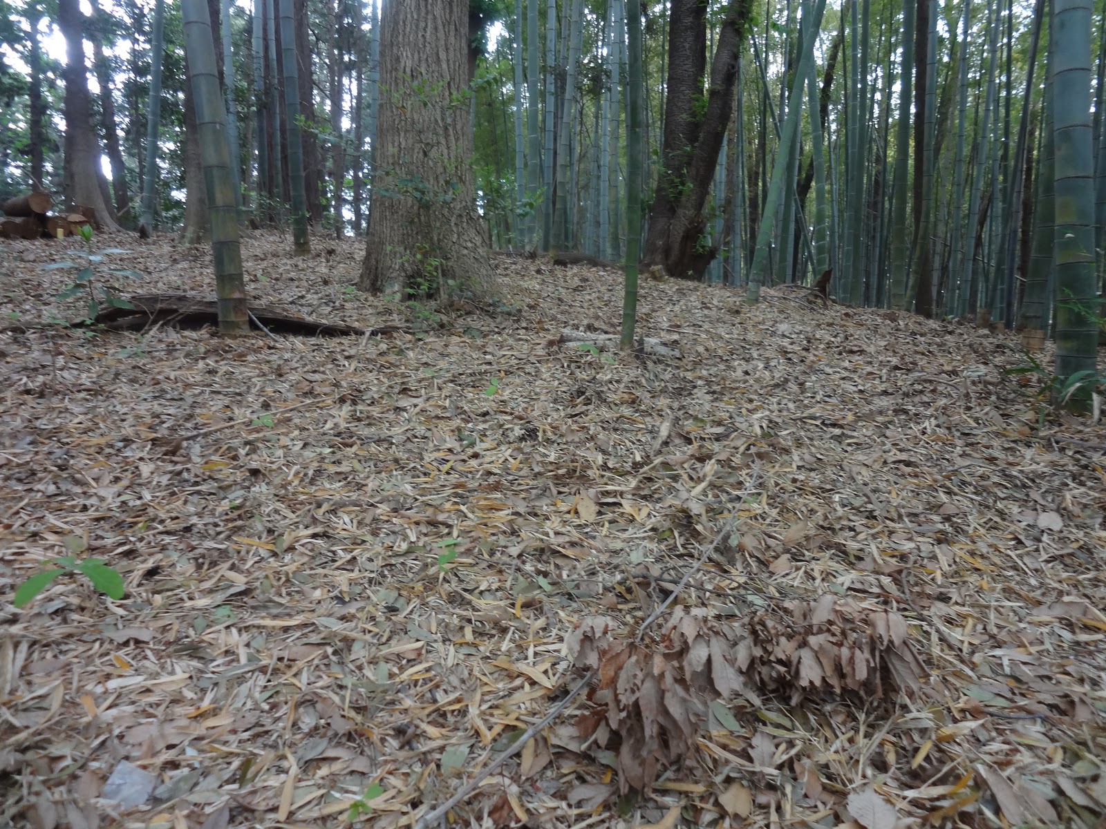
The
fallen leaves and bushy small trees were once useful for firewood and tinder.
Japanese forest people also coppiced suitable trees regularly for baking
charcoal, and rearing shiitake mushrooms. When people used forest in this way,
the climate for Kanagawa and Tokyo would provide forests with lots of coppiced
trees but fewer evergreens, as we find in today’s hiking course. In contrast, Yokohama’s
Niiharu Citizen Forest 新治市民の森 has large Quercues actissima
and Quercus serrata AND lots of oaks
and laurels. We know landlords for Niiharu stopped using the forest around
1950. Clear forest floor around Mt. Jimba indicates villagers of Sanogawa
community managed forest floor frequently, and probably until recently.
Actually, in this hiking, we can find a ruin of kiln for charcoal baking,
surrounded by coppiced trees. Measuring the size of Quercues in this mountain,
I guess people shuttled to the kiln and cut trees around it till the 1960s.

We can
see how stratum of Kobotoke Group was used in the remnant of the kiln. The
piled up rocks are all flat like a sheet. It would have been very convenient to
build a structure with such rocks. Granted they are old, but the material look
porous even for my amateur eyes. From the point of the kiln, the road of the
hiking course becomes more and more dry and gravelly. Yeah, in Tanzawa we can
meet lots of scree-covered slopes. But they are rockier. Here, the soil beneath
our shoes is also rocky but finer. This is a parched mountain. We frequently
meet with parts of road made of slanted stratum. After about one hour climb
from the entrance of the hiking course, we arrive at a crossing with Ichino’o
Ridge. From here to the peak of Mt. Jimba, it’s a main street of the hiking
course. The roots of trees show up bony on the ground. It’s a sign of large volume
of visitors … After half an hour from the crossing, we reach to the peak of Mt.
Jimba.
 |
This
hole was once a kiln for charcoal baking.
You see? The ground of the area is
clean.
No evergreens found here,
and deciduous trees grow in folk.
It’s the
sign of coppicing.
And the trees are not large.
They are not old as we find in
Niiharu.
When forest floor in Kanto Region
can receive lots of sun shine
during winter,
shade-loving evergreens have disadvantage to grow. |
 |
| Kobotoke
Group stratum we can see up close. |
 |
| Desiccated
… |
 |
| The
southern slope of Ichino’o Ridge is afforested area. |
 |
| Ichino’o
Ridge |
 |
It’s
amazing to see violets open their flowers
in such a stumped hiking road. |
 |
We are
entering the peak of Mt. Jimba.
The place has 3 mountain huts/café and a toilet. |
Literal
translation of Jimba is “a stable for war horses.” Archeologists found the peak
of Mt. Jimba has been a meadow for centuries. Villagers from the foot of the
mountain used the place to harvest thatches for their houses. Legend says when
Warlord Takeda Shingen 武田信玄, the protagonist of Kurosawa’s “Ran,” attacked the
territory of his neighbor warlord, Hojo Clan 後北条氏 of
Odawara 小田原, he came to the peak of Mt. Jimba from Kofu 甲府, and set up his main position. We can understand
the logic of his choice. The view from the peak of Mt. Jimba is wide. Weather
permitting, we can figure out Tokyo Skytree over there, and Enoshima Island 江の島 to the south. To the west is Mt. Fuji and the
northern mountains are of Okutama and Chichibu. It’s the best location to plan
your next move to attack Tokyo. Interestingly, the other sides of slopes for
the mountains in the north of Mt. Jimba has stratum formulated during Jurassic Period, i.e. one period older than Kobotoke Group. I recalled the peak of
Tanzawa Mountains spreading to the south of Mt. Jimba is made of stratum one period
younger than Kobotoke Group … Kobotoke Group can be found in a very narrow
area. It’s really a stripped crust sticking to the large land mass … woooooow …
 |
| To the
peak of Mt. Jimba |
 |
The
peak. Many people hike here these days.
A former meadow is now like a picnic lawn. |
 |
At the
top there is this indicator showing
the names of mountains and landmarks
we can
see from Mt. Jimba. |
 |
| It was
supposed to be able to admire Mt. Fuji over there … |
 |
The
other side of the mountain we can see here,
Mt. Shoto (ASL 990.3m) 生藤山 is of Jurassic Period. |
From
the peak of Mt. Jimba, we can descend to (1) Sanogawa community again, (2) straight
down to Mt.
Jimba Hiking Course Stop via Ichino’o Ridge, or (3) down north to Jimba
Kogen-shita 陣馬高原下 Bus Stop in Tokyo. All takes about 2 hours to the bus stop. Whichever
direction you take, the bus service is quite limited to JR Fujino Station (;
time table from Wada Stop is here) and JR Takao Station 高尾 (; time table from Jimba
Kogen-shita is here) so that we should measure the length of picnic at the top
of Mt. Jimba. To Sanogawa community, we can either take the same route at the
first crossing we took for climbing, or turn right at the second crossing with Ichino’o
Ridge. In this route, we reach to Sanogawa community via front yards of local
houses. Before arriving to the paved way from Wada Stop, we once again see the
forests of the village on Kobotoke Group. The forests near the houses are of
deciduous broad-leaved trees and higher elevation is sometimes covered by afforested
conifers. In spring, the contrast of continuing hues of green on the slopes,
with dotting white-pink colors of cherry blossoms, is like an Impressionist
painting … I just wondered the scenery might be thanks to dry Kobotoke Group.
If the soil could keep water more, this area should have had larger population
with more rice paddies, and more traces of human activities, aka development. It
did not happen. The soil beneath our shoes today continues to be gravelly and
powdery. Hmmmmmm ...
 |
The
second crossing on Ichino’o Ridge.
The road on the left of this photo is Ichino’o
Ridge.
To Sanogawa Community we take the narrower road of the right. |
 |
| The
road is of fine clay … |
 |
| Sanogawa
Community in spring … |
Do you
know where people say the best place for cherry blossoms is in Tokyo? It’s
along the ridge way from Mt. Takao to Mt. Jimba. They say in every late April,
old trees of Cerasus jamasakura
decorate the ridge of deep mountains quietly but gorgeously. On a map from Mt.
Takao to Mt. Jimba, it’s about 5.5 hours … Let me see if I can try this itinerary
next spring. The route is entirely on Kobotoke Group. The hiking route must be
dry, gravelly and powdery.
If
you find an environmental issues in Kanagawa Prefecture, please make a contact
with Kanagawa
Natural Environment Conservation Center 神奈川県自然環境保全センター
657
Nanasawa, Atsugi City, 243-0121 〒243-0121 厚木市七沢657
Phone: 046-248-0323