
The access to Yadoriki Forest is the easiest by car. From Tokyo or Yokohama, you simply leave Tomei Express Way at Ohi-Matsuda IC, and go to Route 246 to the direction of Tokyo. Approx. 20K from the IC, on the left, you’ll see 7/11 Convenience Store and Restaurant Mimi 三味 (that is famous for its beef dishes). Turn left at the corner of 7/11, which directs us into Prefectural Road #710. Go straight till the end and in front of you is Yadoriki Forest. Route 710 is also a commuter bus route for the Forest. When you use public transportation, get off Odakyu Odawara Line 小田急小田原線 at Shin-Matsuda Station 新松田駅, and leave from the north exit. From # 3 stop, take a commuter bus service for about half an hour by Fujikyu-Shonan Bus 富士急湘南バス (Time table, here). Route 710 is a bit of a surprise road. When we turn left at 7/11, the scenery from the car window suggests we are leaving behind human settlements … Then, we first meet with a huge construction site that is for the Daini Tomei Expressway (the Second Tomei) 第二東名 that is coming from Toyota City 豊田市 (Toyota-Higashi 豊田東 JCT) and currently reaching to Gotemba City 御殿場市 (Gotemba 御殿場 JCT) at the foot of Mt. Fuji. … No matter, the 710 road continues to run along the surface of the mountain. An entrance to Odawara Golf Club Matsuda Course appears on the right, and soon the way starts to descend. All of a sudden, a town appears below us along the Nakatsu-gawa River 中津川. It is Yadoriki community 寄. When I’ve first been there via Route 710, I was honestly surprised: I didn’t expect there was that large human district tucked in the deep mountains. The community gained its name in 1876 when 7 villages along Nakatsu-gawa River decided to merge together. Yadoriki 寄 in Japanese means “coming together to cooperate.” Sounds nice, doesn’t it?
 |
| #3 Bus
Stop in front of the north exit of Shin-Matsuda station |
 |
| When
we leave Shin-Matsuda station bldg., you turn left, and find a small stand almost next to the railway track which is a ticket booth for Fujikyu-Shonan Bus. They sell return tickets between the station and Yadoriki 寄 that can save 100 yen for adult. |
 |
| For a
while, this is almost all for what you see from the window after 7/11. |
 |
| Then, suddenly, this. |
We arrive at Yadoriki 寄 bus terminal stop either by car or by bus. When we use the commuter bus service, we walk from here along the road 710 and Nakatsu-gawa River for 2K until the parking lot of the Forest. When you drive, please drive carefully especially from here as there is no guardrail but occasional road blocks due to mini landslide with rocks tumbling down to the paved road. Having said that, this path is pretty present to walk. It’s going up one way, but surely is a good strolling experience in quiet and pure mountain air. In early March, the route is adorned by Kawazu-zakura (Cerasus lannesiana Carrière, 1872 ‘Kawazu-zakura’) whose flowers of bright pink have enthusiasts. This cherry blossom can last for about one month so that unlike Someiyoshino, whose peak could be less than a day, we can take it easy to enjoy the show. 😊 The riverbed has lots of Japanese knotweed and sorrell. Though they are public enemy #1 in the UK, they are one of the early spring delicacies for Japanese cuisine. (Recipes, here.) It seems to me locals are harvesting them regularly. The river runs fast, with very clear water. Warning: to fish here, you need license. Please check Matsuda Town Office, here. At the point where the road gets narrower there is an inn, Yadorogi Villa やどろぎ荘. We just keep on going in front of the inn, to meet on the left a camping site, Miroku Camp Field ミロクキャンプ場 (whose homepage is the same as Yadorogi Villa), and on the right an entrance of Mimawaribu Forest Road 三廻部林道 (permit-holders-only route). After half an hour of relaxed amble, we’ll be welcomed an impressive red of Yadoriki Oh-hashi Bridge 寄大橋. You can park your car at the foot of this bridge. We are now at the entrance of Yadorki Forest. Oh, by the way, the river changes its name from Nakatsu-gawa River to Yadoriki Stream 寄沢 at Yadoriki Oh-hashi Bridge. So, I call it Yadoriki Stream from here.
 |
| Yadoriki
terminal bus stop. Here, if you eat something in the restaurant which we can see on the right in the photo, it’s OK to use their toilet. Otherwise, just start walking to Yadoriki Forest and within 5 min. or so, there is a public facility on the right. |
 |
| Standing
back to the bus stop, turn right to Nakatsu-gawa River is the road to Yadoriki Forest. The ridge over there, in the bottom of this photo, continues to the peak of Mt. Nabewari 鍋割山 (1272m ASL). On the left of this route is Nakatsu-gawa River, and on the right is adorned by pink flowers of Kawazu-zakura every March. Alternatively, turning left at the bus stop is one of the safer routes to Mt. Nabewari via Omote-Tanzawa Kanagawa Citizen Forest 表丹沢県民の森. |
 |
| Here is the public toilet. |
 |
| Looking
Yadoriki community from a point near Yadorogi Villa. Pastoral … |
 |
| Nakatsu-gawa
River along Route 710. Jolly gargling of stream is really refreshing! The river is important resource for agri-business of the area. Please do not change the flow by building stone dams for fun. |
 |
| The
entrance of Miroku Camp Field is
decorated with wooden sculptures of animals we can find in the area. Please remember the figure of deer is prominent here. |
 |
| To the
right is permit-holders-only route of Mimawaribu Forest Road. |
 |
| After
the junction with Mimawaribu Forest Road, we can find lots of Corydalis pallida var. tenuis along the road side. During March-May, they show pretty yellow flowers, but … they are poisonous. This plant loves mountainous soil prone to collapse. Oh, so typical for Yadoriki … |
 |
| Over there is Yadoriki Oh-hashi Bridge. |
 |
| The
end of Road 710, i.e., the beginning of Yadoriki Water Conservation Forest. You can park your car where the yellow arrow suggests in the photo. We can see the gate of the Forest over there. |
Kanagawa
Prefecture takes care of Yadoriki Water Conservation Forest やどりき水源林, and often Kanagawa Forest Instructors help
the Office in actual management activities, like thinning conifers and weeding
the undergrowth. The Instructors helped the donners for Forests of Growing to
plant their seedlings in Yadoriki. They arrange fun activities for anybody
coming to the Forest, such as concerts and napping events in hammocks (; for
FY2017, the schedule is here). The most regular activity by the Instructors is
weekend walks. When you come to the gate of the Forest at 10:00 or 13:00 every
Saturday and Sunday (except for December - February), your Forest Instructor is
ready to guide you. The Forest has 3 excursion routes: Route A, B, and
Forest-Road. Route B and semi-paved Forest-Road routes are on the east side of
Yadoriki Stream. Route A is on the west. Yadoriki
Stream has very fast flow going down a steep valley especially near the entrance
to the trekking road to Mt. Nabewari. It makes having lasting structure very
expensive. i.e. there is no permanent bridge to cross the river after Yadoriki
Oh-hashi Bridge. (Caution: when you read the map for Yadoriki Forest. It looks
like there is a permanent bridge.) If you walk with the Instructors, Routes A and
Forest-Road can be combined by crossing Yadoriki Stream with a mobile bridge the
Instructors provide. That could be a bonus!
 |
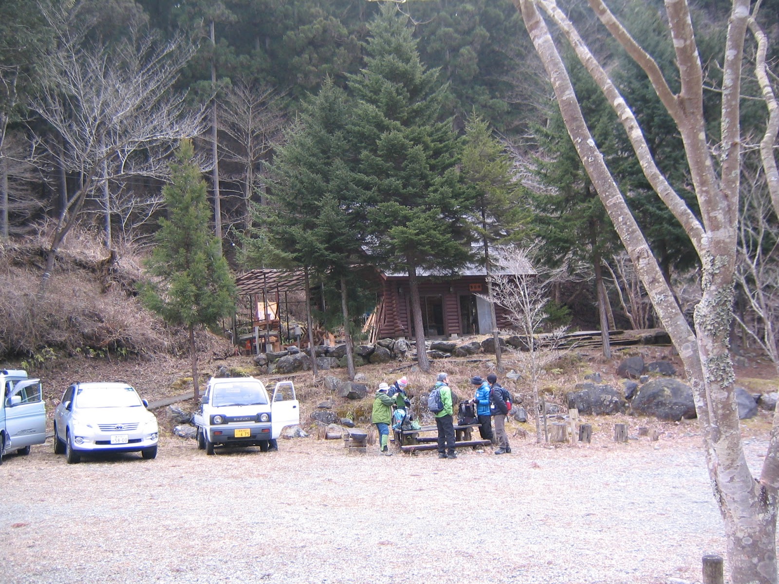
| When
you enter from the gate of Yadoriki Forest, ahead of you is the management cottage of the Forest. It is open when Instructors are there. |
 |
| The
outside shelf of the cottage provides free maps and other info for the visitors. The place also has a form of mountaineering registration with a drop box. In case you plan to go up to Mt. Nabewari (鍋割山 1272m ASL), Mt. Ameyama (雨山 1176m ASL), and/or Mt. Hinokidakka (檜岳 1167m ASL), it is highly advisable to leave your note here. As I tell you last week, this is the gateway to the routes many died with crumbling rocks. The prefectural police strongly recommends to take this route only for very well experienced group of people. |
 |
| In
front of the cottage, a notice board is telling us any news in the Forest. |
 |
| About
200m from the management cottage, there are public toilets, soaps provided. Would you please switch off the light after your use? And please carry back used sanitary products. (Flushing toilet papers is OK.) Thank you. |
 |
| 50m or
so up from the toilet, there is a meeting cottage (with another toilets; open only for events). Only when you join the tour by the Forest Instructors, you can park your car here. |
Less than 1K semi-paved Forest Road Route starts from the gate of Yadoriki Forest and ends at the entrance to the way to Mt. Nabewari, which is the other side of the end of Route A across the Yadoriki Stream. It includes a part of Route B till the meeting cottage. From the meeting cottage, the slope of the Forest Road is getting steeper, and lasts as such till the end. On the left, down there is the Yadoriki Stream. During winter and early spring when the leaves of deciduous trees don’t exist, we can see Takigoh Fall 滝郷ノ瀧 across the Stream from the point near the meeting cottage. (Photos taken by an expert mountaineer can be seen here.) At the foot of Takigoh Fall which is a double fall of 15m high, there is a memorial for a guy who died several years ago. We cannot approach there from the Forest Road as there is no bridge to cross Yadoriki Stream now. A legend says if you visit around this point of Yadoriki Forest during night, ghosts of hikers welcome you for cursing. 😖 Horror stories aside, the scenery of along the Forest Road Route is frankly pleasant. Birds, including Asian stubtail and Daurian redstart, are happily singing with the back chorus of bubbling from the stream. The riverbed is occupied by Alnus sieboldiana that is a pioneer plant for colluvium. On the right of the route shows why this plant is thriving down there … Very steep slope is here and there collapsing. Actually, the place is popular among geologists to explain the soil of Tanzawa for beginners. At the end of the Route, there is a notice board saying from there is a trekking road to mountain peaks only for experts. It’s the terrain of Asian black bears. Let’s go to Route A and B, then.
 |
| We can see a bit of Takigoh Fall here. |
 |
| A forest of Alnus sieboldiana in winter on the riverbed of Yadoriki Stream |
 |
| On the Forest Road Route, we will be greeted by this fine specimen of pillow lava created at the bottom of Pacific Ocean some 1.7 billion years ago. It’s here now because of plate tectonics. |
 |
| And so, the land is collapsing … have you noticed the layer of granite is not horizontal? It’s also the result of crush between the Eurasian and Philippine plates. |
 |
| Near the end of the Forest Road Route, there is a colony of Euptelea polyandra hich is an endemic species of Japan. This photo was supposed to be for the full-bloom of their brownish-pink peculiar flowers in March … Theirs are very understating flowers … |
 |
| The end of the Forest Road Route. Be aware of bears! |
If you find environmental problems in
Yadoriki Forest, please make a contact to
Kanagawa Nature Conservation Center 神奈川県自然環境保全センター
657 Nanasawa, Atsugi City, 243-0121 〒243-0121 厚木市七沢657
Phone: 046-248-0323
No comments:
Post a Comment