One
hiking course we can visit easily from Miyagase Dam 宮ケ瀬ダム is to Mt. Minamiyama 南山. We enter its hiking course from Prefectural Aikawa Park 県立あいかわ公園. Please
take 30 minutes bus ride with Kanacyu Bus 神奈中バス from Odakyu Hon’atsugui Station 小田急本厚木駅. Leaving from the North Exit of the Station, you
find Bus Stop #1 in front of you. Catch services Atsu-01 厚01 or Atsu-14 厚14 (time table, here) to Hanbara 半原, and get off at Aikawa Oh’hashi Bus Stop 愛川大橋. The bus stop is on a bridge over Nakatsu River 中津川. Find a way to go down to a narrow community road
running under the bridge. Start walking to the mountains in the west. After
about 10 minutes or so, you’ll be greeted by a folk crossing with a gate. It’s an
entrance to Prefectural Aikawa Park and Miyagase Dam. If you take a path to the
right, you enter Aikawa Park with an ample parking and a museum commemorating
communities flooded by the dam. You then meander inside the Park, gradually
climbing to a paved road to the crest of the dam with the dam admin office. If
you reach to this road via “Forest of Flowers (花の森),” you find an entrance to the hiking route at the
opposite side of your exit from the park. If you reach to the road via “Wind
Hill (風の丘),” you can see the dam admin on your left. Please
go down to the right for about 400m, and find the entrance. From the entrance,
the first 50m or so is very steep climbing of steps, which gradually becomes steep
going up. About 600m later, the road becomes less sharp. I think it is a typical
beginning of hiking route in Kanagawa. Just be patient. One caution. Please use
toilets before entering the hiking road today!
 |
| Aikawa
Oh’hashi Bus Stop |
 |
Proceeding
to the same direction of the commuter bus
a bit from the bus stop,
we can find
this steps going down. Just take it, and |
 |
we’ll
be greeted by this sign
showing us to the Park and the Dam. |
 |
The
gate is at the end of this photo.
If we take the road on the right,
we’re
straight into Aikawa Park. |
 |
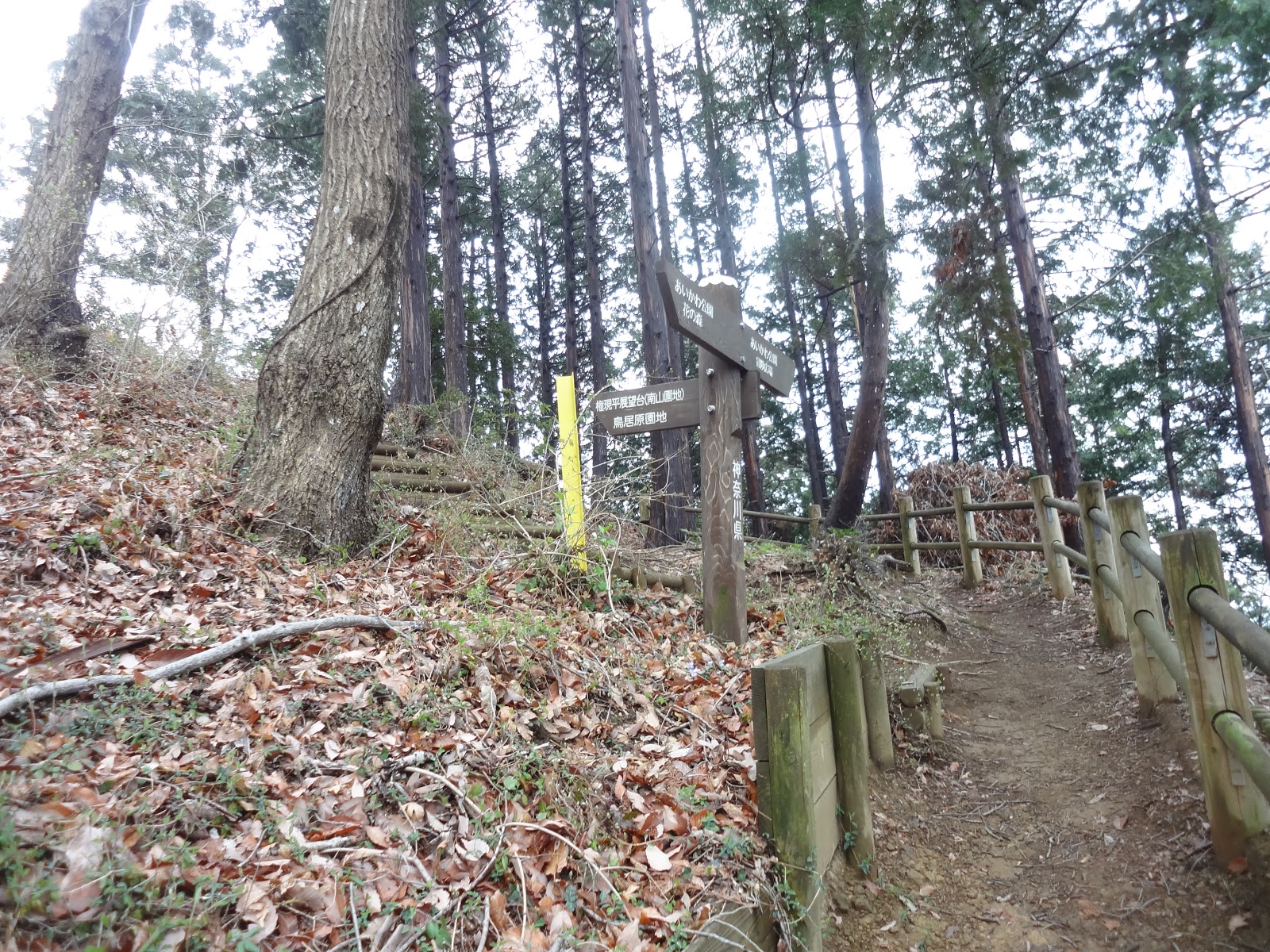
| An
entrance to hiking course to Mt. Minamiyama |
 |
If you
come from the dam admin,
please go down this road to find the entrance on your
left. |
 |
We go
up here. About a box on our right, it’s for Deet.
More to it, later. |
 |
| The
first 600m is like this. |
 |
Take
to the left here.
The sign says (in Japanese), “Toriihara 鳥居原, this way.”
Please always follow to “Toriihara.” |
 |
| Up, up
up … |
Throughout
the ascent, we can see Lake Miyagase 宮ケ瀬湖 on our left beyond the forest. We hear departure announcements
for sightseeing boat from the jetty next to the museum. Yet, we are now in a
deep forest, and peer through the woods activities of humans. It’s a very
strange feeling. Animals might observe us as we do now in the forest. Actually,
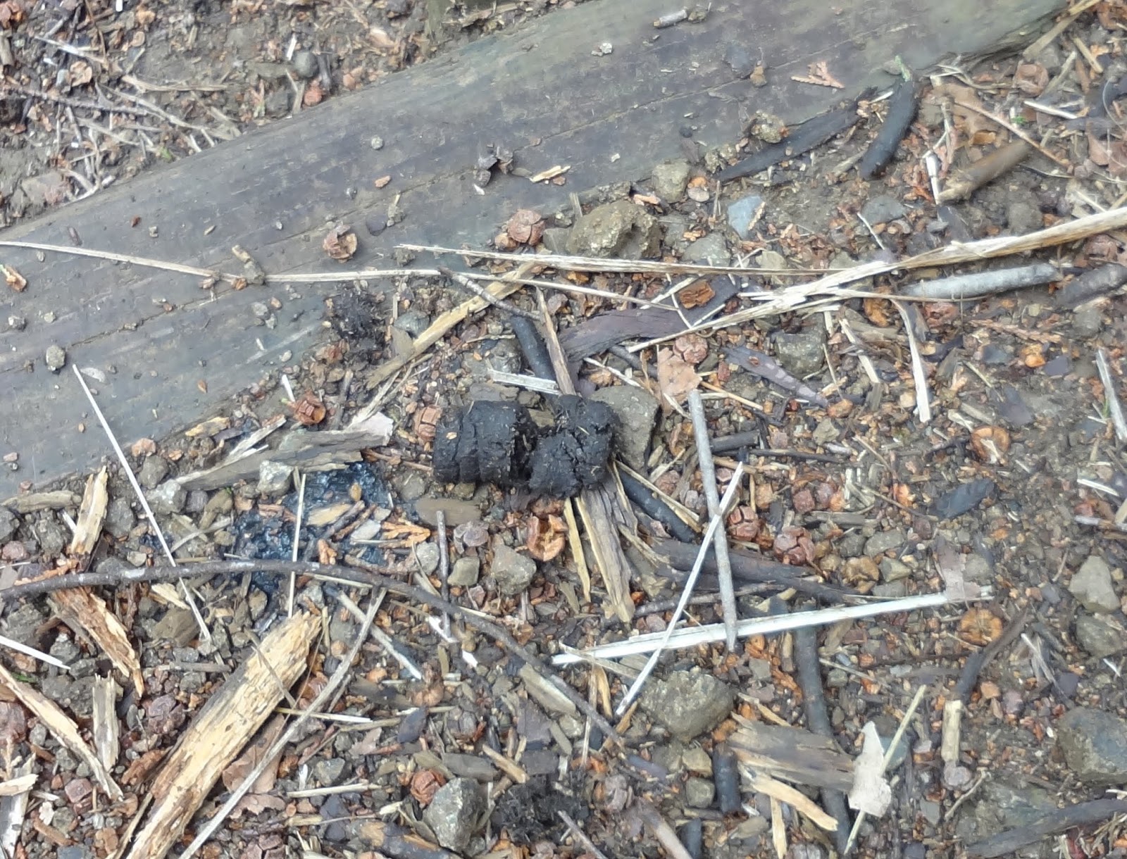
during today’s hike late March, I’ve met lots of droppings of several kinds. I
actually met with a raccoon dog, and a monkey during the walk. There also was a
notice to hunters warning, “This is a popular hiking route. Please be very
careful during your hunt.” Hmmmmmm. At least when hunters are active in Tanzawa
丹沢, they pitch many banners at entrances and lunch
spaces notifying their hunt … Please be very careful when you find such ads of
hunters here … In the end, the most dangerous creature is homo sapience. *sigh*
 |
| Lake Miyagase over there |
 |
| Monkey! |
 |
| Miyagase
Dam over there. |
 |
| A
warning to hunters: Don’t shoot! |
 |
| Poop 1 ... fox? |
 |
| Poop 2
… of boar,
perhaps? |
 |
| Poop 3
… could be of monkey …? |
 |
Poop 4.
This one is easy.
It’s a family toilet for raccoon dogs. |
 |
Poop 5.
Could be of Japanese marten.
They love to do this along roads. |
 |
| Poop 6.
Weasel? |
From
the entrance we first meet a Y crossing. Just take the left road. After about 1300m
walk from the entrance to the hiking road, we reach to the peak of Mt.
Minamiyama (ASL 544m). Yeah, altitude-wise, it’s not much. But the view from
here is worth visiting. When it’s fine, we can see the main ridges of Tanzawa.
Even if it’s cloudy (as I experienced), we can see an expanse of Lake Miyagase
down below. The difference of elevation between Aikawa Park and Mt. Minamiyama
is about 100m. I was a sort of impressed what this variance can make. Both sides
of the hiking route is covered by silver grasses along the ridge line of
Minamiyama … If I were a small animal, this would be an ideal housing place to
hide and have a rest … Sure enough we can listen bird singing somewhere here …
 |
| To Mt.
Minamiyama … |
 |
| The
top of Mt. Minamiyama |
 |
er,
well, Tanzawa ridges were supposed to be over there.
Though, I found the
scenery dreamy … |
 |
| Adelante,
por favor. |
Actually,
Mt. Minamiyama is not the highest point we visit today. Please follow the same continuing
path to the west. We can meet several roads on the right going down to another
road running almost parallel to the ridge, 200m down. Locals use this as a walking
road and semi-utility route in the mountain. I looked down to this direction
from the ridge way, and guessed at least we cannot expect a view from there.
Let’s stick to a standard hiking route. The ridge is a pleasant trekking road
in a deep mountain. We continue to see Lake Miyagase on the left between the
woods, but no longer hear sales talks for tourists’ attraction. The place is
quiet. In late March, cute spring flowers started to open their faces in the
roadside. From Mt. Minamiyama after 1200m walk of pleasant ridge way, we reach
to Gongendaira 権現平, ASL 568.5m, which is the highest
we visit today. From here, we can see Miyagase Dam and downtowns of Kanagawa
and Tokyo straight over there. Gongendaira is an open space with several picnic
benches. If your group is large, the point would be for your party. Oh, one
caution. Though here they installed public toilet, it seemed to me the facility
is out of order ... I told you. You’d better finish that before entering the
mountain ...
 |
| Ridgeway
from the peak of Mt. Minamiyama |
 |
Please
go straight in this forest of coniferous trees.
Then … |
 |
I
found this! It’s a remnant of a bed for flying squirrel.
Yap. They love to live
in a forest of coniferous trees. |
 |
| I
think it’s Viola bissetii. |
 |
| Gongendaira.
You see? It’s for a large group. |
 |
| Just
over there is Miyagase Dam. |
From
Gongendaira, let’s go down to Toriihara Fureai no Yakata Park 鳥居原ふれあいの館, which is one of the tourists’ spot to see Lake Miyagase,
and the terminal bus stop to go to Hashimoto Station of JR East. (Time Table is
here for the bus: caution the service is limited.) It’s rapid and nice descend.
As before, we meet several departing road on the right, but just keep on
choosing the left. Especially near Gongendaira, both sides of this route are
adorned by Lindera praecox. In
late March, the road had delicately sweet scent of cute yellow flowers of the tree.
It’s a relaxing early spring hiking … Then, about 600m later from Gongendaira,
thunderous sounds of exhausts started to come in the forest. Eventually, in the
middle of downhill, we can see a Toriihara Park in front of us over there. That’s
our final destination. We proceed further, and meet with a wooden ladder going down
to a paved road. This road is supposed to be a “forestry road,” but actually a
part of tourists’ road circulating Lake Miyagase. This part of circular road is
narrow, with winding ups and downs, and pretty well-paved. Especially during
weekends, those people with Ferrari or Honda 750, et al come here to have their
kind of fun. From the exit of our hiking route to pedestrian walkway, we have
to cross this road. Though it’s not wide, please really REALLY be careful! Let’s
go north-west from here to Toriihara Fureai no Yakata Park.
 |
| Please
go left to Toriihara. |
 |
| Down,
down, down … |
 |
| To
Toriihara, please. |
 |
| We’re
more or less ending to see this sight now … |
 |
| Flowers
of Lindera
praecox made a carpet for me along the way. |
 |
| A
forest of sweet aroma … |
 |
It’s
another remnant of a bed for flying squirrel
… Did s/he use moss for more
cushion? |
 |
| Our destination
is over there. |
 |
| Let’s
go down this. |
 |
| Goal!
Could you see another box here? It’s for Deet. |
 |
| Speed
way |
Toriihara
Fureai no Yakata Park is well-known among motor-biking or sports car enthusiasts.
Every weekend, they congregate before their race along the “forestry” road. The
place also has a restaurant, souvenir place, ice cream, and well-equipped
toilet with washlets. Their farmers’ market sell locally produced fresh veggies,
including jarapeños and anchos in summer. Compared with supermarkets
in downtown, this is a bargain place! The Park sits on the north shore of Lake
Miyagase, and they have jetty for tourists’ boat. We steeply descend from the
souvenir shop to the pier. Theirs are completely artificially made slopes to synthetically
made dam lake with beautifully designed color schemes of garden greens. It
seemed to me they moved soil massively here for creating dam … I could not find
standard wild plants normally sprouting early spring as I met in Mt. Minamiyama
... At the edge of the park near the water, we can see a part of the forest
spared from flooding. I also found traces of wild boars. They excavated the
ground for earthworms or the like. The animal didn’t care aesthetic intention
of garden designers AT ALL. That’s … something, yeah.
 |
| Humans |
 |
| Farmers’
market |
 |
| We’ve
visited there. |
 |
| The
bus stop |
 |
| Toriihara
Fureai no Yakata Park |
One
last note: this area is famous for vampire leeches during summer. They become
active once the temperature reaches to 20°C. Both entrances to the hiking route provide Deet,
free of charge, to spray your trekking shoes for preparation. Good luck for
your summer hike, or go there from November to April / early May. 😉
 |
The
closure should be with nice aroma
… this is Lindera
umbellata. |
If you find an environmental issues
in Kanagawa Prefecture, please make a contact with Kanagawa Natural Environment Conservation Center 神奈川県自然環境保全センター
657 Nanasawa, Atsugi City, 243-0121 〒243-0121 厚木市七沢657
Phone: 046-248-0323


No comments:
Post a Comment