
Before reaching to Yadoriki Water Source Forest やどりき水源林, Matsuda Town has several nice and not so demanding hiking courses. This week and the next, I tell you my adventure in one of such routes. I’ve been there this autumn. It was a wonderful experience with serene autumn colors. But, this course has probably one of the most beautiful cherry blossom sceneries in Tanzawa mountains 丹沢. You can plan your cherry blossom party there for spring. Planning cherry blossom hike would be a fun activity at the beginning of a year, wouldn’t it? The main peak for this adventure is Mt. Takamatsu 高松山, ASL 801.2m. Here is a rough timeline (of very slow pace):
Start: JR Matsuda Station or Odakyu Shin-Matsuda Station
From the station +10 min: Entering the route to Nishi-Hirahata Park on Prefectural Road 72
From the above point +30 min: Matsudayama Herb House
From the Herb House +70 min: Historical Landmark for Saimyoji Temple 最明寺史跡公園
From the Historical Landmark +40 min: Takamatsu Community of Yamakita Town
From Takamatsu Community +40 min: Hisari Pass
From Hisari Pass +50 min: Peak of Mt. Takamatsu
From the peak +40 min: Hisari Pass
From Hisari Pass +50 min: Choju-bashi Bridge in Matsuda Town
From Choju-bashi Bridge +30 min: Tashiro-mukai Bus Stop

 |
| From
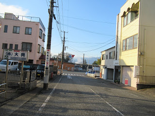
JR station, please take this road going up straight to the Route 72. Oh, from JR station, we can observe Mt. Fuji, FYI. |
 |
| This
is the signpost leading us to Herb House. Please follow the direction. |
 |
| Above us is the Tomei Expressway. |
 |
| When
we reach to the other side of the underpass, there is this community road with a signpost “Herb Garden, this way.” |
 |
| We admire Mt. Fuji beyond Tomei. |
 |
| Shortcut steps to Herb House. |
 |
| These
are Cerasus × kanzakura ‘Kawazu-zakura’. When they are in full bloom, we admire their pink clouds even from the stations below. |
 |
| The vista from the steps. Below is Tomei Expressway. Over there to the east is Sagami Bay in rising sun. |
 |
| Herb
House. When COVID problem is settled, fun programs there will resume ... fingers crossed. |
 |
| Mt.
Fuji from Herb House. Could you see a small snowed triangle on the southeast slope of Fuji? It has name, Kofuji aka Petit Fuji. It’s the sign winter has come. |
 |
| Could
you figure out parking spaces on the right of this photo? The community road we departed for the short cut comes here. Over there is Hakone mountains. |
From the Herb House(; toilet is here), we pass by mini-train station for kids’ SL called Furusato Railway ふるさと鉄道 (; operation suspended due to COVID). We next find Nature House 自然館 and enter Matsudayama Green Wind Promenade 松田山みどりの風自然遊歩道. From the Nature House, it is a wide hiking way for 10 minutes or so, but soon the route joins with a paved agricultural road frequently used by locals. It’s almost one way up. Please close the door for the anti-deer fence when you enter the paved road here; the damaged done by the animal could be devastating for ag business. We appreciate your cooperation. 😉 The scenery from Nature House is mainly tangerine orchards which continues for a while to the paved ag road. Farmers do their orange business and sell their product from late autumn to winter. In May the place is filled with fragrance of their flowers. We are welcomed by a wide view of Sagami Bay, and eventually big Mt. Fuji. Brownie point #2. All in all, it’s lovely. 😊 When the orchard begins to fade away, the forest around us is both coniferous afforestation and natural broad-leaved trees. When I’ve been there in December, different kinds of maple tree leaves showed off delicate hue of their peak yellow and red. Brownie point #3 from the forest. 😊 I dreamed of laying on the forest floor to appreciate them for hours … my hiking mates said, “Yeah, you do it. We go ahead” … Admitting, it was a damned chilly morning … The paved road ends at Historical Landmark for Saimyoji Temple 最明寺史跡公園. Here is another toilet!
 |
| The mini train station for SL |
 |
| Nature House |
 |
| We walk along the track for a while, then, |
 |
| The way departs to Matsudayama Green Wind Promenade. |
 |
| The first part of the Promenade is like this. |
 |
| Please
close this gate securely after you pass. Thank you. |
 |
| Along the way is lots of farmland with superb view. |
 |
| Oranges are in their season in December. |
 |
| After
taking the paved agricultural road for 10 minutes or so, please turn right at this point. It’s a (mainly) pedestrian shortcut. |
 |
| Soon,
we encounter another gate preventing free roaming of deer. Please close it after you pass. Thank you. |
 |
| The
other side is a paved road, the continuation of the route we’ve taken before we enter the shortcut. |
 |
| Oh, it’s so beautiful … |
 |
| The forestry road going to Saimyoji Temple. |
 |
| We’ve almost reached to the Historical Site. |
Historical Landmark for Saimyoji Temple is the place where in the 13th century Saimyoji Temple 最明寺 was built by Priest Gen’en 源延, one of the senior vassals for Minamoto-no-Yoritomo 源頼朝. Yoritomo was the founder of Kamakura National Government 鎌倉幕府 at the end of the 12th century. Until the 15th century the temple was rich and famous but when Japan entered the aera of civil wars, the sanctuary lost its backing. Temple buildings were gone. Pious locals kept on cultivating rice paddies and farmland of the temple and held annual religious ceremony at the place on every April 10th. Thanks to their effort the Landmark preserves 700 years old basic design of the temple garden. It has a quiet pond surrounded by lots of spring flowering trees, including many kinds of cherries, flower peaches and forsythia. From March to May, the place is in full bloom. As there is no public transportation for the place and parking space is limited, not many people come to admire them. Those flowers have their annual peak in a very calm, meditative way in Shangri-la style. Today’s Brownie Point #4 😊. The place is one of the best cherry blossom points for the entire Tanzawa area.
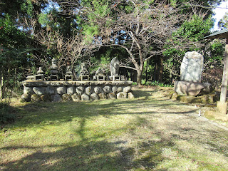 |
| The
Historic Landmark does not have any old buildings, but several ancient stone statues and archeological sites. |
 |
| The
pond in December. Please imagine all these treessurrounding the water will bloom in pink, red, and yellow in few months … |
We take a small road going up from the northern shore of the pond. To the west, we can admire the entire shape of elegant Mt. Fuji. During the season, it’s the path through cherry blossom arcade … Fuji-yama is floating above pink clouds of cherry flowers. Brownie Point #5. It must be stunning ... We soon reach to a T-crossing. To the west relatively wide, but not paved road slowly goes down. Along this direction, we encounter several times signposts saying “Mushizawa Kodoh 虫沢古道: Mt. Takamatsu 高松山, This Way.” This route is an old commuter road, i.e. Kodoh 古道 in Japanese. These days locals try to make the route visitor friendly and situates enough signposts for hikers. Just follow advice of locals. Oh, one important notice. At the point where we enter Mushizawa Kodoh from Saimyoji Temple, there is another way to the east which is a continuation of Matsudayama Green Wind Promenade. Please DO NOT take this direction. Due to monster typhoons two years ago, the route has several impassable collapses. Having said that, this direction has nice viewing points before the landslide points. You can go there, return to Saimyoji, and give up Mt. Takamatsu ... For today, Our destination is Mt. Takamatsu. The vegetation along Mushizawa Kodoh is mainly afforested conifers with broad leaved trees here and there. Eventually down below, we see houses of Takamatsu 高松 community of Yamakita Town 山北町. It’s a quiet mountainous village. From here climbing up to Mt. Takamatsu begins. More, next week. 😉
 |
| From the pond, the road goes up. |
 |
| I
imagined all the trees here would have pink bloom, and Mt. Fuji would be still capped by snow … |
 |
| Now we’re in Mushizawa Kodoh. |
 |
| Signposts
are like this. Could you see a plastic bottle is attached to the pillar? It contains salt. This is Tanzawa and when the temperature goes up above 20, vampire leeches are active along the hiking road. So, locals provide this service: when you find a leech on your body, sprinkle salt! |
 |
| Takamatsu community started to appear down there. |
 |
| Takamatsu community |
If you find environmental issues in Kanagawa Prefecture, please make a contact with Kanagawa Natural Environment Conservation Center 神奈川県自然環境保全センター
657 Nanasawa, Atsugi City, 243-0121
〒243-0121 厚木市七沢657
Phone: 046-248-0323
You can send an enquiry to them by clicking the bottom line of their homepage at http://www.pref.kanagawa.jp/div/1644/
No comments:
Post a Comment