
The west of the Park’s paved ridge road is a small valley whose western rim is next to another farming community connecting to Samukawa Town 寒川町. Do you remember Samukawa Town has Samukawa Shrine 寒川神社? The shrine’s status was the Premier Provincial Shrine of Sagami Region, an old administrative division for Kanagawa Prefecture (my post on December 30, 2016). At the corner of West Parking, nearest point to the Park Centre, there are archeological sites from BC 2500 to AD 700. Actually, from this point to the northern most part of the west ridge way scholars found several archeological facts of pre-historic Japan. People did primitive agriculture, hunted wild animals such as boars, deer, rabbits, etc, and used boats for fishing. … er, between 10000 to 1500 years ago, Japanese archipelago experienced a peculiar Holocene glacial retreat whose cause was definitely different from the other parts of the planet. It’s a different topic I may return for another forest … Anyway, during this period, villagers in the inland Chigasaki Satoyama Park had easier access to the sea. They lived good life with healthy nutrition. Since then for more than 6 millennia, the area around Satoyama Park was home of lots of people. Wow. That might be one of the reasons why ancient Samukawa Shrine is near to Chigasaki Satoyama Park. And since October 2001, the valley where western ridge road of the Park looks down eastward tries to preserve such tradition by volunteers.
 |
| The
corner between West Parking and the west ridge road. Underground of this area has lots of archeological info. |
When we go down to the east valley from the west ridge way, we can see remnants of more recent agricultural village. Let’s go down to the “Forest of Heisei 平成の森“ from the open space of Main Entrance. It’s a steep slope (and steps for a short cut) surrounded by landscaped deciduous trees. This part of the Park is known by locals for bird watching. i.e. The place has a good biodiversity where birds can find lots of food. From the end of the Forest of Heisei, we can see a sort of elongated open space where a strolling path runs in the middle. This is the traces of productive rice paddies and veggie patches of yesteryears. Now the local volunteers came here to do organic farming and reviving old orchard of chestnuts, plums, etc. Let’s take the road in the middle of fields. There appears an old house on our left. It’s a reproduction of traditional farmers house in the area, named “House of the Valley (Yato-no-ie 谷の家).” Nowadays, the place serves as a community hall and resting place for visitors. I imagined this was a typical design of Yato 谷戸 villages in hilly Kanagawa Prefecture. Numerous small valleys were for producing foods, and they are protected by firewood forests. In Japanese “Ya” means valley, and “to” means households.
 |
| Forest of Heisei |
 |
| A walking path runs through … |
 |
| On our
left is wheat. On our right is chestnuts orchard volunteers try to revive. |
 |
| House of the Valley |
In front of the House of the Valley is a pond, called Serizawa Pond 芹沢の池. This was once for rice cultivation. The modern-day standard for Japanese rice production is controlling water flow to paddies. In springtime, farmers till wet or dried field while they nurture rice seedlings in swampy seedbed. They then draw water to their paddies, prepare their field for seedlings, and plant the young rice in a very shallow pond-like paddies. Normally, these processes are completed by the middle of June before hot and humid Japanese summer. When autumn comes, well-ripen, golden ears of rice bow deeply. Farmers drain the paddies to protect ripen product from typhoon flood and harvest them on a dried ground. Having said that, there are lots of spots in Japan such water control was technically difficult. In Kanagawa Prefecture, the delta of Sagami River 相模川 was famous as such challenging place untill some 70 years ago (“A Verbatim Account of Kanagawa’s Meal,” 1992). Once in those villages, farmers seeded rice directly in their pond, and harvested the ear on rudimentary boats. Chigasaki Satoyama Park may have been for a such tradition. Serizawa Pond is said to be used for this cultivation method. Now in winter, it is for families of migratory birds. Peaceful place …
* A Verbatim Account of Kanagawa’s Meal, Series: Japanese Food Culture Volume 14, Nobunkyo, Tokyo, 1992. 聞書き「神奈川の食事」日本の食生活全集14 農文協 1992
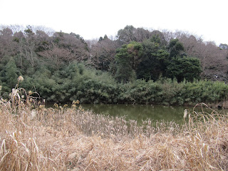 |
| Serizawa Pond |
 |
| It’s a sort of … dignified scenery, don’t you think? |
Further north of the pond there are rice paddies followed by another veggie fields. Both sides of the walking path in this valley are cultivated by local volunteers. Forests begins from the east and west edges of the agricultural land. The valley we walk now is typical Yato. It would have been very efficient setting to maximize food production without fossil fuels. Moreover, by being Yato, this area has kept rich biodiversity. Swampy rice fields, then dried veggie patches surrounded by forests of both broadleaved and coniferous trees ... Variety of environment has sustained many creatures to live here. Now the volunteers are recording “animal and vegetables” they have found in the Park. As long as there is no COVID issues, they hold monthly nature observation party every 4th Sunday. If you’re interested in the occasions, just come to the open space in front of the Park Center at 10:00 in the morning. It’s open to everybody, and free of charge. Or, you can join more regular weekend activities for organic farming and nature observation parties. Please make a contact with
Chigasaki Satoyama Park Club Secretariat 茅ケ崎里山公園倶楽部事務局
www.kanagawa-park.or.jp/tigasakisatoyamaclub/index.html
email: chigasato@ganagawa-park.or.jp
They have English map of nature walk for the Park. I guess some of the volunteers may welcome non-Japanese speakers for their meeting. Oh, caution: the northern most part of agricultural fields in the valley is professional farmers’ private property. Don’t stray in, or you risk yourself for criminal offence of trespassing.
 |
| In January, all the paddies are sleeping … |
 |
| waiting for the spring to come … |
Northern most ridgeways of the Park has two features. West way has a small forest of cherry trees that leads us to an open space where we can admire big Mt. Fuji beyond Hakone mountains. That will be a perfect spot for spring picnic. East way ends with well-tended volunteer farm field, and BBQ space with ample parking space. BBQ opens from March 1 to 31 (weekends only), then from Aril 1st to November 30th (closed Thursdays). RSVP. Please check Park’s HP below for table availability and prices. BBQ place has the office called the House of Village (Sato-no-ie 里の家) where we can find several booklets in English. To enjoy this Park the office could be more informative for non-Japanese speakers. And finally, very important information to have a good weekend in Chigasaki Satoyama Park. This park has many toilet spots! Please grab a map from anywhere you can find in the park, or download it from their HP. They could be very useful tool, honestly. 😊
 |
| Cherry
orchard on west ridge way in January. It would be beautiful in late March … |
 |
| Open
space at the northern end of west ridge way. If it is fine we can admire mountains of Tanzawa, Hakone, and Fuji from here … |
 |
| House of Village |
 |
| BBQ space is closed during winter. |
 |
| Another veggie place cultivated by volunteers on the east ridge. |
 |
| West ridge way |
Chigasaki Satoyama Park 茅ケ崎里山公園
1030 Serizawa, Chigasaki, Kanagawa, 253-0008
〒253-0008 茅ケ崎市芹沢1030
Phone: 0467-50-6058
FAX: 0467-50-6358
No comments:
Post a Comment