Friday, November 25, 2022

This year, autumn leaves in Kanagawa are beautiful …


Megalopolis Tokyo area is in relatively temperate region, at about 36°N of latitude. Adding global warming, autumn and winter here are (it seems to me) getting milder. That would be a nice thing for humans withstanding cold weather. But, for the beauty of autumn forest, it is a drawback. Especially for Kanagawa Prefecture, we are in the south of border that is a boundary for deciduous Japanese beech to thrive in lower altitude. Yokohama is too warm for beech to be ubiquitous. (FYI, the border is the ridge way of Mt. Takao. Please see my posts on February 25, March 4 and 11 this year.) Fall temperatures here are often hesitating to go down in November and December. Accordingly, leaves are left at the whim of going up and down of warmth. They say leaves turn colors in autumn in order to cope with weakening photosynthesis due to shorter days but still strong ultraviolet rays. When photosynthesis becomes less, their body starts to reduce inside green chlorophyll, which makes remaining yellow carotenoid stand out. Then, the trees produce anthocyanin that can absorb ultraviolet rays and so ward off toxicity. Lots of anthocyanin renders such beautiful red. If the shortening of days is insufficient as in 36°N, and climate is milder for ordinary deciduous trees, their leaves may be confused “to be colored, or not to be colored.”


The autumn colors in lower part of Kanagawa are often of a mixed result … We Kanagawa Forest Instructors speculate so. Especially those senior instructors whose hometowns were in Hokkaido or Tohoku areas, this theory would sound very strong. “You see? The forests of my birthplace have far more beautiful autumn than in Kanagawa.” “Oh, mine in Iwate Prefecture as well.” “Hm. Kanagawa is too close to the Pacific Ocean and strong impacts of typhoons can remain. In contrast, not for my Hokkaido (with quiet ha-ha-ha from inner pride) …” “You know, typhoons can wind up salty vapor from sea, and let it down in raindrops.” “That’s damage the leaves. Salt.” “Oh, yes. Here is a good warm place, but too temperate for charming autumn leaves.” … Normally, conversation goes like this. Certainly, when we see yellowish but wearied tone of mountain slopes in front of us, it is hard to deny such claims …


That was our conversation around this time of the year. HOWEVER! With some sort of miracle, the 2022 autumn colors in Kanagawa is SPECTACULAR. We’re a bit taken aback. “Why?” “COP27 says the World is definitely warming …” “It means our maple trees are more in a disadvantaged.” “Yep, even so, Look!!!” Come to think of it, this year we have not had a strong typhoon landing on our prefecture. That would be why the yellows and reds in our forests are so vivid. And it’s still a beginning. Kanagawa’s autumn colors will be peaked around the end of November! Mmmmmmmmmmmmmmmmmmmmmmmmmmmmm …. Please come out and have a nice stroll in beautiful fall forests. Rain or shine, the atmosphere is so calming …


It’s early November around ASL1100m.
 Beautiful Japanese beeches …

Lower Tanzawa

I think they are Conocephalum toyotae, but not sure.
 Does moss turn colors in autumn?


If you find environmental issues in Kanagawa Prefecture, please make a contact with Kanagawa Natural Environment Conservation Center 神奈川県自然環境保全センター

657 Nanasawa, Atsugi City, 243-0121
〒243-0121 厚木市七沢657
Phone: 046-248-0323

You can send an enquiry to them by clicking the bottom line of their homepage at http://www.pref.kanagawa.jp/div/1644/


Friday, November 18, 2022

Satoyama and Endangered Species: Kanagawa Water Source Monitoring Volunteers 4


Sagami River originates from Oshino-Hakkai 忍野八海. Along its journey to Sagami Bay, there are lots of springs on its banks, like the one we’ve visited last week. The water seeps in the forests alongside the river joins the mainstream from such springs. Or, the other satoyama forests do not stand right next to the mainstream of Sagami River. The water from them first comes out to a tributary that eventually joins the mainstream. A tributary itself could have even smaller tributaries, or rills, running along a tiny valley between tiny hills. Sagami River has lots of such systems in its basin. One such place for Sagami River is in Atsugi Kodomonomori Park (Atsugi Kids’ Forest Park あつぎこどもの森公園) in Atsugi City.

The map of Atsugi Kodomonomori Park

Atsugi Kodomonomori Park is 8ha of satoyama forests where volunteers maintain the ecology of forests and rice paddies through their activities. My first impression of the place was like “Oh, it’s similar to Niiharu!” The forest of the Park invited me to stroll freely with lots of vegetations and insects … The place itself deserves one independent post. I spare the introduction of the forest for my later adventure. Today, the topic is aquatic creatures we’ve found in Kodomonomori Park. Certainly, the streams we met there were about max 50cm wide trickles running beside rice paddies volunteers taking care of. At the upstream end of such rivulets, there are small ponds, of 10m in diameter for the biggest. Some ponds are natural, and the others were man-made when yesteryear farmers cultivated the place for their rice and veggies. The tricklets pour into Ogino River 荻野川 whose ultimate water source is in the slopes of Mt. Takatori 鷹取山 (ASL 522.1m) near Lake Miyagase. Some 7km downstream from Kodomonomori Park is near JR Atsugi Station where Ogino River joins the mainstream of Sagami River. For the entire river system of Sagami River, the water from Kodomonomori Park is for downstream part. Very interestingly, the creatures we’ve encountered there were different from those near Camping Ground last week which located a bit upstream from the Kodomonomori Park.

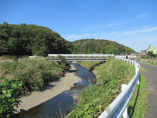
Ogino River.
Could you figure out a white bridge over there?
 Beyond it there is a mouth of a streamlet
 we did a study the other day.

The way water moves was also different. Sure, the rill flows to lower ground but the speed of it was not much for one sunny autumn weekend. The amount of water was also not threatening as we’ve encountered in the mainstream, or in Yadoriki Stream for steep Tanzawa mountains. Its “riverbed” could be sometimes a bedrock, but the majority was mud. The banks were often constructed by retaining walls made of wood panels. Never mind for such man-made structure, wild vegetations are covering the slope of banks, which is a typical scenery of traditional Japanese rice paddies. Unless you’re careful enough you may dunk your feet into muddy stream. The ponds have shores continuing from the vegetation for rivulets, and their offshore have bushes of common reeds. There were lots of dragonflies flying over our heads … Shaking plants as we did last week would yield some catch, but the best approach here could be plunging the landing nets in the mud to capture the living things in one swoop.

The flow of a rill was like this.

The left of the photo is a pond / a rice paddy.
Across the wooden footpath on the right is actually a rivulet.
Could you see lots of satoyama vegetation?

Natural shore of a pond in Kodomonomori Park.
Arrow-leaved tearthumb was in full-bloom.

Have you noticed a small stream running on our left?

Golden-ringed dragonfly was everywhere.

So did I play a mud game in the small trickles of Kodonomomori Park. At the beginning of our research, the pros from Environmental Research Center said “The number of species we’ll encounter here will be far smaller, as the water mass we enter today is definitely smaller.” Hm. I see. The number of species could be limited compared to these from tributaries or mainstream, for sure. But, surprisingly, it was far easier to capture aquatic creatures from the mud in the Park. It was like the dwellers of mud were disrupted their idyllic country life suddenly by our landing nets. There were lots of pond skaters and water striders. My specimen jar captured lavae of several kinds of dragonflies from big to small. River snails were also there. It was so effortless to capture Lefua echigonia, Hotokedojou in Japanese. In contrast, I have not met American crawfish.

The way to collect creatures is,
 first, scoop the mud,
then wash it away in the pond
until mainly leaves and other things remain in the net.
 In this way, we can find our catch in a plastic vat.

My specimen

If American crawfish thrived in Kodomonomori Park, they would eat up all Lefua echigonia for their lunch. Lefua echigonia is Japanese endemic, and endangered species. Once upon a time before industrialization, the fish was ubiquitous in rice paddies surrounded by satoyama forests all over. Now such combo of forest + agricultural field is endangered scenery and so for Lefua echigonia. They need this particular ecosystem for survival. Moreover, the fish is carnivorous, which means it competes with American crawfish. Alas, they do not have super-weapon of craws as the crawfish to fight for survival. It is a common story in Japanese satoyama water where American crawfish is present Lefua echigonia lose their survival game for food. They are eaten for extinction by Americans. Yet, it was so simple on that weekend to capture the fish there. There was not much presence of American crawfish in Kodomonomori Park. Why?

Lots of Lefua echigonia and Japanese freshwater crabs,
sans American crawfish

There is at least one explanation. For years, the Park constantly solicits help from local kids who come to play in the Park to fish American crawfish and bring their catch to the admin office. There, the crawfish becomes roast crawfish to be discarded as garbage (… I think it might be possible to make a gourmet snack from the crawfish if they wish). In addition, when adult volunteers find some trace of crawfish, they execute mop-up operations in their field. The Park was opened in 2016 and such endeavor of citizenry from the beginning protects the endangered species. Once Toshiko Kitagawa 北川淑子of Tokyo University told us in a seminar for Niiharu (; my post on June 24, 2016). Satoyama environment of Japan has been the way to maintain biodiversity of our neighbor. It was replaced by commercial mono-cultivation during the 1950s to the 1980s. Biodiversity of our forests declined rapidly. Once we restore our previous way of satoyama management, some creatures can come back, and prosper as before … so she said. Abundant but endangered Lefua echigonia in Atsugi Kodomonomori Park would be one evidence, I guess.


We also encountered many mantises near the water,
together with

Gordian worms.
It means these poor mantises were infected
and brought to the water to jump in and die
 for the grown-up worm to enjoy aquatic adult life.
 Let’s pray for them …

Oh, I have to tell you one thing, really. When we did our research in the waters of Kodomonomori Park, we obtained permissions from Atsugi City and Kanagawa Prefecture. We showed several green banners around our activity notifying we were doing official water quality survey. If you visit Kodomonomori Park please refrain from picking flowers or fishing Lefua echigonia. They are precious members of biodiverse Park that is now a rare species in suburbs. Thank you indeed for your cooperation. 😉 I have not yet finished microscopic study with the specimen collected during the activities … Hopefully I will meet the deadline for reporting in early January. Later in this blog, I’ll let you know exactly what we’ve found during this year’s field study.


If you find environmental issues in waters of Kanagawa Prefecture, please make a contact with Kanagawa Environmental Research Center 神奈川県環境科学センター

1-3-39 Shinomiya, Hiratsuka City, 254-0014
〒254-0014平塚市四之宮1-3-39
Phone: 0463-24-3311
FAX: 0463-24-3300
k-center@k-erc.pref.kanagawa.jp 

Friday, November 11, 2022

American crawfishes in Sagami River: Kanagawa Water Source Monitoring Volunteers 3


Sagami River 相模川 originates from Oshino-hakkai 忍野八海, a vast welling of water where rain and snow falling on Mt Fuji comes out to the surface. It then flows to the east through a narrow valley between Okutama Mountains 奥多摩 and Tanzawa Mountains 丹沢. Infuriatingly for Tokyo, it then turns right, er … to the south I mean, in Sagamihara City which is right in front of Tokyo. (“Oh, if it came to our direction, our water problem would be blah-blah-blah,” you know?) The river runs through so-so-suburban area of Kanagawa, then pours to Sagami Bay near fashionable beach resorts. The way the river flows like

(1) Upstream goes through the relatively flat mountain plateau of Mt. Fuji, which is in Yamanashi Prefecture 山梨県,

(2) Midstream runs through mountainous area, which is like upstream for the other rivers, and

(3) Downstream passes between large human settlements, in a more relaxed manner.

So, for the case of Sagami River, typical feature of nature for “upstream” can be seen in the midstream along Route 20, aka Koshu Kaido Highway 甲州街道, the north-most part of our prefecture. We people of Kanagawa normally get the image of Sagami River from its “downstream” flow, after turning right in Sagamihara. The forests we find along the downstream of Sagami River are often satoyama-kind (in relatively higher altitude) or the city parks. Inevitably, collecting specimens from such part of the river is different from the way we take in Yadoriki Water Source Forest やどりき水源林.

Sagami River at a bit upstream from Tomei Ebina JCT.
Here is about 11km upstream from the mouth
 of the river to Sagami Bay,
i.e., the downstream part of the river.

Today, I tell you my adventure in one of such spots of Sagami River. It was near Higashi-Oshima Camping Ground of Sagamihara City 東大島キャンプ場. The spot we’ve done our research was not in the Camping Ground itself, and I won’t tell you where exactly. Reason? Yeah, the place is right after the Sagami River turns to the south after Lake Tsukui 津久井湖 / Shiroyama Dam 城山ダム. There, the mainstream of the river has lots of water. It flows relatively rapidly. It is not advisable for anybody jumping into the water as it is too risky. Besides, doing fishing at that place needs to purchase fishing rights from the local Fishery Cooperative. I don’t think it is much of the info for you without the explanation of such business deals … (If you want to purchase a day pass for fishing near the camping ground, the Office of Higash-Oshima Camping Ground has an info. Good luck.) In any case, we did not wade in the mainstream of Sagami River, but did our study in a sidepool. There is a spring gathering water from satoyama forests near the Camping Ground. The water from these ag-area first come out to the ground from the spring, then pours into the mainstream via a small exit. Its small bank is full of water-loving grasses and aquatic plants. Such vegetation can also be found along the mainstream, but inside the pool has far more calmer flow. That’s the point for aquatic creatures to survive.

Higashi-Oshima Camping Ground
Before entering parking space for the Camping Ground,
 we are greeted by rice paddies and farmlands.
 The water for such agricultural field joins with
 rainwater dropped on the satoyama forests around,
 and comes out to Sagami River.

Basically, unless it is a fish, the aquatic lives along the river use cleverly the continuation of environment from dry forest to water flow. Amphibians often use mass of water only for mating and tadpole-times. They spend most of their adult life in forest. Insects spend their childhood in water but come out of it when they grow up. Even pond skaters or water striders do not use underwater for their mature days. Grasses and aquatic plants are nice places to cling to for larvae, or to use as corridors between dry land and water area. So, when a spring has such vegetation around, it is the place where we focus to hunt for aquatic creatures. Instead of turning up the stones in riverbeds as in Yadoriki Stream 寄沢, this time we shook water bushes above our landing nets and checked what came out.

The spring pond we studied

According to Mr. Hasegawa of Kanagawa Environmental Research Center, the place we waded in the other day was much larger pond before. Now a sandbank that separated the spring pool and the mainstream became much narrower and the main flow Sagami River is approaching to the calm spring well. We may not have a pool next year once a large typhoon comes. Such is the nature of river … Still, in October 2022, the pond was peaceful enough for us to collect waterborne creatures. Inevitably, our net was stuffed by the remnants of plants we shook, and we searched for the animals hiding in a pile of leaves and stems. At first glance, there was nothing, but once we got used to, we started to spot a small movement of something. We caught these creatures by a small spoon or tweezers and threw them into a jar of 80% ethanol for making specimen. They will be examined under the microscope later for exact identification.

Beyond the sandbank is the mainstream of Sagami River.

But inside the pool is calm.

Pile of leaves and stems …

“Please do not throw fishes and amphibians into the ethanol jar. Instead, catch them in a ziplock or small acrylic aquariums filled with river water and aquatic plants. Take photos of them from many angles, and release. Later we identify them from these pictures.” Oh, I see. So, my jar contained several larvae for aquatic insects and lots of lake prawns + pequeño American crawfishes. “Gee … we have to identify these prawns if they are local or invasive species …” “It seems to us the number of American crawfishes are getting larger.” The pros said. Some invasive species are defined by Ministry of Environment as non-desirable creatures in Japanese wilderness. They compete with native kinds for food, or even devour the locals. American crawfishes are making havoc by acting that way in satoyama environment. Finding them at a point where Sagami River enters downstream is not good news. In contrast, from Yadoriki Stream I have never encountered prawns or crawfishes. It would be the case streams running through deep valleys of Tanzawa are still resisting the invasion of non-native species. Yadoriki Stream behaves nicely as water source. Yeah, the spring pool off the Camping Ground has a nicely clear water where fishes swam around our feet, but …

Making specimens

The water is coming out from the sand. Could you see it?

Even though, downstream part of Sagami River is not dominated by uneasy findings. Next week, I show you another place we did for water-monitoring. Our findings were different, I tell you.


If you find environmental issues in waters of Kanagawa Prefecture, please make a contact with Kanagawa Environmental Research Center 神奈川県環境科学センター

1-3-39 Shinomiya, Hiratsuka City, 254-0014
〒254-0014平塚市四之宮1-3-39
Phone: 0463-24-3311
FAX: 0463-24-3300
k-center@k-erc.pref.kanagawa.jp 

Friday, November 4, 2022

Mid-term Exams for Yadoriki Stream: Kanagawa Water Source Monitoring Volunteers 2


Of course, by definition, river flows down from high to low land. It means, when it meets with forests, it runs through different kinds of forests at each altitude. Yadoriki Water Source Forest やどりき水源林 is one of the beginnings of Sakawa River 酒匂川. The forest spreads over steep slopes of Western Tanzawa 西丹沢, whose soil consists often of gravels of green tuff and scorias, i.e. not so fertile. Yadoriki Stream 寄沢 is narrow when it shines, but steep and rocky slope of Western Tanzawa mountains make the flow rapid torrent. Riverbed is made of rocks that could be large. Basically water of Yadoriki Stream is cold even if we’re in high summer.
 

A typical scenery of Yadoriki Stream

The way to collect specimen from Yadoriki Stream is also place-specific. When we study aquatic lives there, we position the mouth of our landing net facing to the upstream and kick rocks and gravels at the shallow bottom of the stream. The creatures clinging to the stones are washed away by fast flow and captured in the net. The living things we can collect from such environment are peculiar bunch. Normally, we cannot meet them in lower part of the same river, where it is wider with lots of warmer water and the flow is slow at least comparatively. In my post on June 10, I showed you we collected these creatures in early summer this year from Yadoriki Stream:

Kajika frog (tadpoles)
Kamimuria quadrata

Perissoneura Paradoxa

Epeorus latifolium

Planarian Flatworms

Oyamia gibba


Kanagawa Prefecture gives scores for each of these creatures. The numbers are adjusted to Kanagawa’s river from the Japanese Biological Monitoring Working Party (BMWP) published in 2017 from the Ministry of Environment. Japanese BMWP itself is modified for Japan based on English version started in 1976. So, Kanagawa’s number is mixed race grandkids of original Brits. With this benchmark,
  • Kajika frog and Planarian Flatworms are Indicator species for very clean stream of water source area. 
  • Kamimuria quadrata, Perissoneura Paradoxa, Oyamia gibba and Epeorus latifolium earn score 9 which is the second highest mark for the monitoring score.
“Please put your pen on the desk …”

The way to calculate the grade of the river based on the observation is summing up the numbers each creature earns, then divide the total by the number of species we’ve encountered. In today’s example, let’s spare indicator species for this calculation (; they have already earned perfect score as an indicator). We do the math like

(Kamimuria quadrata’s score + Perissoneura Paradoxa’s score + Oyamia gibba’s score + Epeorus latifolium’s score) / (Number of species in this equation, i.e. 4)

= (9+9+9+9) / 4

= 9

Perfect score is 10, which says the stream has impeccable quality. 9 is the second highest grade. Yadoriki stream in June 2022 showed A-student result for water quality exam. We Water Source Monitoring Volunteers do our study up to this point and report our findings to Kanagawa Environmental Research Center. The researchers at the Center tally annually our findings and make the result public. The latest report for Sakawa River is for 2019 which is downloadable from here. This fiscal year’s deadline for reporting to the Center is early January. We’re in a final stretch now.

Grade sheet!

We can choose the point of a river to monitor according to our preference, as long as the water is in either Sagami 相模川 or Sakawa River System. (The project is to monitor water quality for daily use of people in Kanagawa, paid by taxpayers, mate.) I happen to be a Forest Instructor commuting to Yadoriki Water Source Forest periodically. In addition, we Forest Instructors do such study in Yadoriki Stream for years. So, studying Yadoriki Stream with landing nets and plastic bats is … a bit of boring. But in this project, the Research Center gives us trainings in different point of a river, like in a middle basin, or far smaller water source in a forest of agricultural area, similar to Niiharu Citizen Forest 新治市民の森. (Niiharu Forest is in the system of Tsurumi River 鶴見川 that is not a source for potable water. So, the place is not covered in this project.) The way to collect creatures in these places is a bit different from that in Yadoriki. Next week, I tell you my adventure in such environment.

Our tools for water monitoring

If you find environmental issues in waters of Kanagawa Prefecture, please make a contact with Kanagawa Environmental Research Center 神奈川県環境科学センター

1-3-39 Shinomiya, Hiratsuka City, 254-0014
〒254-0014平塚市四之宮1-3-39
Phone: 0463-24-3311
FAX: 0463-24-3300
k-center@k-erc.pref.kanagawa.jp