
Alternative approach for sampling DNA from Kanagawa’s rivers is simply drawing a bottle of water, refrigerating, and sending it to the lab. We’re given a plastic bottle for 1L and asked to take river water. Simple. We have to be careful about just two things. One is avoiding contamination during water collection. We wear gloves, wash the bottle carefully before packing water, and always stand downstream during water collection. After gathering water into the bottle, we add RNAlater to suppress the break-down of DNA. Another important thing is trickier. The researcher must start processing the contents of the bottle within 48 hours of the collection, provided the water is preserved as is from the river. So, we refrigerate it immediately after the collection in a freezer bag, and rush to a courier’s office for express delivery to the Prefecture’s lab.
 |
| Collecting water |
In any case, compared with the syringe method, it is far easier to collect DNA samples this way. In addition, it is guaranteed 1L of screening as we don’t have a problem of clogged-up filter. Maybe the only problem is the weight of 1L especially when we bring water from deep mountain. Mr. Hasebe originally worried about the burden and recommended the syringe-method. But in the middle of the year, he said the difference in amount of water possible to be checked could be crucial for studying the sample. So, he started to recommend the bottle-method “if you can carry additional 1K in your backpack.” In Yadoriki Stream 寄沢, I tried syringe-method twice; once during summer, and another in December. I also did bottle-method in December. All three samples showed different results. Curious. Let me explain.
 |
| Yadoriki Stream in one December weekend last year |
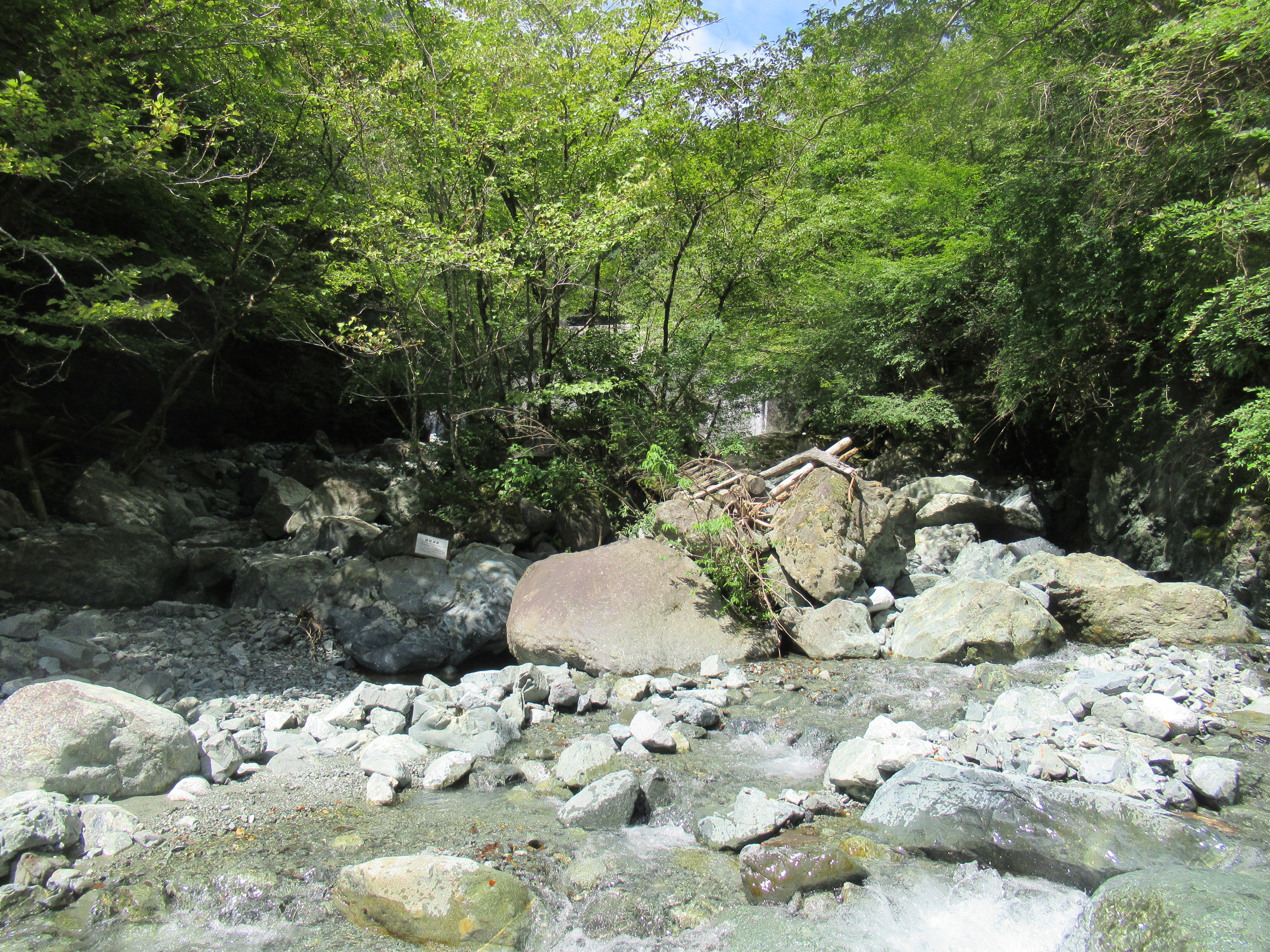
My first trial for DNA was during summer at the place where a forestry road from the gate for Yadoriki Water Source Forest やどりき水源林 ended by meeting with Yadoriki Stream. From that point, there is no road accessible for mechanized vehicles. Immediately beyond the spot, there is a weir to mitigate the impacts of debris flow from upstream. Do you remember there is a famous “always collapsing” south-west slope of Mt. Nabewari 鍋割山 that has the name “Collapse in Hell” (; my post on January 3rd, 2020)? Also, the physical power of stream at the point is perhaps the text-book example for torrent. From the fishes’ point of view, it would be difficult to go further up when they come from downstream. So, the water I filtered there at that time would reflect the lives of fishes swimming above the weir, near to ones of the very origins of Yadoriki Stream, and hence Sakawa River 酒匂川. The result of DNA analysis was … (drum rolls, please) ZILCH, nada, nobody.
 |
| Zilch-point |
 |
| The
end of the forestry road is like this in Yadoriki Water Source Forest. Could you figure out the weir at the bottom of this photo? |
Yeah, come to think of it I don’t have a memory of somebody saying “Oh, you see? I met a shadow of fishes at XYZ (beyond the end of forestry road in Yadoriki Stream).” But, even so, if that part of the estuary for Yadoriki Stream has a certain closed “community” of non-migratory fishes, like small Japanese fluvial sculpin, we might be able to catch the trace of them through DNA. The result may have influenced the design of DNA collecting in Mr. Hasebe’s head. He said “Well, straining the water in the field may have influenced the analysis. Besides, the amount of water is inevitably smaller with syringe compared with a bottle of water … Let’s continue monitoring for next year.” Roger. Very interestingly, a point slightly downstream from the Zilch-point, we had totally different result with bottle-method in December.
 |
| Actually,
there are another two weirs beyond the Zilch-point in Yadoriki Stream … |
We tried the bottle-method in the estuary of Yadoriki Stream at a point slightly before Ushiro-zawa Stream 後沢 joining to Yadoriki Stream. When you take the standard route to Mt. Nabewari from Okura 大倉, the beginning of the final ascend to the peak is named Ushiro-zawa Nokkoshi 後沢乗越 which is a watershed for the east and west of the ridgeway of Mt. Nabewari. Ushiro-zawa Stream gathers water from that very steep western slope and joins with Yadoriki Stream when it meets with the forestry road. It’s a tiny flow of less than 500m long. Having said that, people often boast they spotted the fishes in Ushiro-zawa. (Oh, by the way, the road along Ushiro-zawa reaching Mt. Nabewari is closed for hikers. We need a permit to use the route from the landlord, aka Kanagawa Prefecture. Forest Instructors are OKed. 😊) So, we tried our DNA quest at the very end of Ushiro-zawa just before it joins with Yadoriki Stream. Bingo. Mr. Hasebe found DNAs for Japanese fluvial sculpin, Amur minnow, and Cherry trout.
 |
| This is the point we collected DNA from Ushiro-zawa. |
 |
| Ushiro-zawa |
We collected the Ushiro-zawa’s water about 10m before it joined with Yadoriki Stream. So, it might contain the trace of dwellers of larger Yadoriki Stream. But After Typhoon Hagibis of 2019 (my post on October 18, 2019), the prefecture almost “closed” the joint of two streams and laid an earthen pipe, some 1m in diameter, for Ushiro-zawa Stream to pour to Yadoriki Stream. The aqueduct often clogged after a storm. I don’t think fishes are regular commuters to use such unfriendly route … Maybe short Ushiro-zawa stream has very rich biodiversity, and fishes have their own exclusive community thriving happily there. Impressive …
 |
| Actually, the living things
above water are also very rich along Ushiro-zawa. Last summer, we met a blue-and-white-flycatcher there. It sung a beautiful song … |
The third point we did DNA sampling in Yadoriki Stream last year was at waterfall basin of Takigo-no-taki Fall 滝郷の滝, which is the end of Takigo-sawa Stream 滝郷沢. The water of Takigo-sawa dropped some 20m down at the point where it joins Yadoriki Stream. The water in waterfall basin would concentrate the entire water of Takigo-sawa Stream, we guessed. In December, we used syringe-method to collect DNA. At the time, we could figure out 2 shadows of fishes swimming at the very end of the basin … Promising! The result was … DNAs of Cherry trouts ONLY. The length of Takigo-sawa is more than 1k long, i.e. 3 times longer than Ushiro-zawa. On the other hand, the access to Yadoriki Stream from the waterfall basin is far easier there; constant and relatively shallow stream of some 10m long between the basin and the Yadoriki Stream. During casual summer visits of the Yadoriki Stream near Takigo-no-taki Fall, we can meet Japanese fluvial sculpin here and there. So, we expected the waterfall basin could have contained more variation in terms of DNA. This time, no. It may be due to syringe-method … Or, the 20m difference in elevation could prevent other fishes from entering Takigo-sawa? Curious, curious, curious …
 |
| Takigo-no-taki Fall point |
When we visit Yadoriki Stream, we first notice large red Yadoriki-oh-hashi Bridge 寄大橋, and a high weir, maybe 10m high or more, below the bridge. Swimming beyond the weir could be impossible for a fish. It means all the fishes we meet beyond that point would be non-migratory and endemic. Stray fishes from fish farms downstream are unlikely, unless somebody deliberately discharged one, which is criminal offence in quasi-national parks of Japan. Actually, between the high weir below the red bridge and the one at the end of forestry road, there is another weir before the joints of Ushiro-zawa Stream with Yadoriki Stream. It is also relatively high, maybe of 5m or so. This one would also be difficult to pass for tiny fishes. Is it affecting the privateness of Ushiro-zawa? From last year’s trial, the stream of the richest biodiversity was the tiny Ushiro-zawa Stream. The lives there would be contained in a very small area … Or, was it a temporary result just for 2022? Mr. Hasebe, it seems to me, is wondering if the syringe method misses something due to a small amount of water sample. The quest continues this year … I’ll report you what we’ve met in 2023. Meanwhile, next week, I tell you more about the DNA sampling from Kanagawa’s water source rivers from prefectural policy’s point of view. Pls. stay tuned. 😊
 |
| Yadoriki-oh-hashi Bridge |
Oh, I have to tell you this. Takigo-no-taki Fall is famous as it has handful of victims who tried to climb it up and fell to death. It is constantly washed by gushing water, i.e. very slippery. This is in the south of Mt. Nabewari where the fall can be almost vertical and the Greenschist is dominating rocks. The condition makes the wall for the waterfall easily collapsible against stresses the human weight of supporting points put. By now, we know very well the place does not have value to risk our lives. It’s better to admire it from below. Or, use the waterfall basin as a prayer spot … several religious groups use the place during summer … Please keep it safe.
 |
| Takigo-no-taki Fall |
If you find environmental issues in waters of Kanagawa Prefecture, please make a contact with Kanagawa Environmental Research Center 神奈川県環境科学センター
1-3-39 Shinomiya, Hiratsuka City, 254-0014
〒254-0014平塚市四之宮1-3-39
Phone: 0463-24-3311
FAX: 0463-24-3300
k-center@k-erc.pref.kanagawa.jp
No comments:
Post a Comment