Monday, May 27, 2024

After Crashes: beautiful rocks found in the stream of Tanzawa Mountains 1


Very large Pyroclastic breccia in front of us,
found in Yadoriki Stream. More to it below.

So, thanks to the birth secrets (; my post last week), what we find beneath Tanzawa Mountains is of volcanic origin, more or less. In my post for July 19, 2019, I told you my adventure with the soil in Tanzawa. Beneath the very thin topsoil, there was 40 cm or so volcanic scoria ashes due to Fuji 1707 tephra. In Tanzawa, typical soil for Kanto region is covered by the thing came from Mt. Fuji in the 18th century. Then, deeper down from that, we can encounter the proof of tectonic crashes since 13 million years ago. How can I see such an ancient mega drama? We don‘t have to dig deep down the mountain. The thing we do is simply do picnic on the valleys of Tanzawa Mountains. There are several good valleys we can visit safely especially for escaping summer heat.

Very thin topsoil of Tanzawa area

You just hike Tanzawa Mountains and cross small mountainous valleys. The rocks and riverbeds there are the basic structure of Tanzawa that made by tectonic collides millions of years ago. The topsoil once covered such ancient earth is washed away by the stream. Often, they are tuff created by volcanic ashes and rocks spewed out by primeval under-oceanic volcanos, and piled up in the bottom of antediluvian ocean. It went through humongous pressure machine of tectonic movements which in the end pushed up the volcanic sediment above the sea level.

It’s near Nishi-Tanzawa Visitor Centre.
Lots of rocks, yeah.

Have you noticed the riverbed often have green colour? It‘s green tuff, made by East Pacific Rim Orogeny from 26 to 5 million years ago. For the other kinds of tuffs, we know Tanzawa has fine tuff, coarse tuff, pyroclastic breccia, tuff breccia, lapilli tuff … Yadoriki stream which run through Yadoriki Water Source Forest is an easy place to find these rocks. Below is from my collection found in the riverbed of Yadoriki Stream.
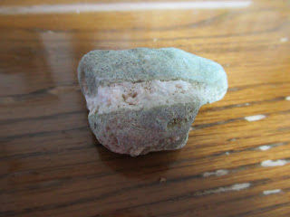
Green tuff

It’s also green tuff with white stripes.

Seeing it through the microscope,
I think it shows piles of ashes.

Coarse tuff

A microscopic photo of the above rock.
It’s a rock which relatively coarse volcanic ashes,
roughly 1/16 to 2mm in diameter,
piled up at the bottom of the sea,
then went through the tectonic pressure machine.

Lapilli tuff

With microscope,
we can see it is made of 2-64mm lapilli
 with volcanic ashes.

Tuff breccia

Now the size of the lapilli is larger than for lapilli tuff,
but the lapilli is less than 50% of the entire rock.

Pyroclastic breccia

Unlike the previous rock,
now the lapilli occupy more than 50 % of the rock.

These palm-sized rocks are probably from large ones that were cracked by landslides and continuous rapid torrent over steep slopes. When we climb upstream for water sources of mountainous valleys in Tanzawa, we can find huge rocks piling up and the amount of water flowing between boulders is smaller. One evidence that sustains the hypothesis can be found at the plunge pool of Takigo Fall 滝郷の滝, in front of the open space with picnic benches of Yadoriki Forest. The height of the fall is about 30m with average width of 2m. We can approach to the shore of the pool and observe rocky layers of earth. With large lapilli inside, we can recognize pyroclastic breccia. This waterfall is famous for its very fragile walls which killed so many climbers trying to rock-climbing. Either using aids of ropes et al or bouldering, the fragile breccia easily collapses by the weight of a climber. If a person falls down 30m on a rock, it would be an instant death. Such crumbly stone can simply become a small souvenir-sized rocks, right? In the end the rocks here are sedimentary.

The upstream of Yadoriki Stream.
The place is famous for its large boulders covering the riverbed.

The plunge pool of Takigo Fall

The riverbeds of Yadoriki Water System can keep having small rocks even around 1000m ASL. Do you remember my adventure to Ameyama Pass 雨山峠 to Yushin Valley ユーシン渓谷 in 2019? Ameyama Pass is at ASL 957m. From the Yadoriki main stream to the Pass, the entire itinerary is on the rocks and scree. Come to think of it, they were once volcanic ashes and lapilli that went through gigantic pressure of crusts and became a mass. Since then, they continue receiving the same pressure to be pushed up to ASL 1000m and beyond. No wonder they become crumbly … Having said that, the rocks we find in Tanzawa mountains are not sedimentary alone. I’ll tell you the other kind next week. They are also very beautiful. 😄

We’re reaching to the Ameyama Pass …
and the route is still like this.

Oh, by the way,
the riverbed in front of the Open Space near Yadoriki Bridge
 (that red one) is not natural one,
 but goes through riparian works many times.
 Reason?
 Frequent monster typhoons cause landslides often
 along Yadoriki Stream,
and block the water flow
that could trigger debris flow to the communities downstream.
 The prefectural office does continuous construction there,
 but Mother Nature always wins.

If you find environmental issues in Kanagawa Prefecture, please make a contact with Kanagawa Natural Environment Conservation Center 神奈川県自然環境保全センター

657 Nanasawa, Atsugi City, 243-0121
〒243-0121 厚木市七沢657
Phone: 046-248-0323

You can send an enquiry to them by clicking the bottom line of their homepage at http://www.pref.kanagawa.jp/div/1644/

Sunday, May 19, 2024

Crash of Titans: the origin of Tanzawa Mountains


Kanagawa Prefecture was on the epicentre for the 1923 Great Kanto Earthquake (; my post on September 15, 2023). It was Sagami Trough that was created by tectonic crush of Philippine Sea and Eurasian Plates. Such movement of earth’s crusts does not only cause mega-earthquake, but also keeps pushing up (Eurasian Plate side) and down (Philippine Sea Plate which goes beneath the Eurasian Plate) the land we’re standing daily. Now, Philippine Sea Plate goes north-west 4cm per year, and thus causes the physical stress on the Eurasian Plate by this magnitude. Such tension has been existing for trillions (or more) of years …


Over there was the epicenter.

Take Tanzawa Mountains 丹沢山地. The steep slopes of the area were once at the bottom of the Ocean whose name was even not Pacific, but Izanagi (the name of creator god for Japanese mythology). Actually, at that time Japanese archipelago did not exist. Many sections of the current Japanese islands were a part of Eurasian Plate. Huge Pressure caused by the crash of Eurasian, Philippine Sea, and North American Plates bended and torn up the upper part of the crusts. The ripped former parts of Eurasian and North American Plates were folded further that make the base of Honshu Island. When the seabed, including the present-day Tanzawa, kept on pushing the Eurasian Plate, the split part from the Eurasian Plate was bended 90° degree, and the huge area of the crust fell to form a huge valley. The dent induced a gigantic gash of sea water inland and created the origin of Japan / East Sea. Along the “shores” of newly born inland sea, the chains of volcanos activated and repeated violent eruptions.

Tanzawa Mountains are getting taller day by day.

The western part of the valley’s shore has now clearly been identified by mortal humans as an enormous fault line slicing Honshu Island. It starts from Itoigawa City 糸魚川市 on Sea of Japan / East Sea side and goes through Sizuoka City 静岡市 on Pacific Ocean side. The fault line is called Itoigawa-Shizuoka Tectonic Line. (Er, well, no surprise for this name.) In contrast, the exact location of the eastern shore of the valley is under a lively debate among scholars. One thing is sure. The area sandwiched by these two shores is a region considered to have one of the most active volcanic mountains on earth. The area has a name, Fossa Magna. Tectonic crushes make fissures on the earth’s crust. The mantle of the planetary core finds corridors to release its heat et al and melts the upper layer of the planet. Lava is made deep down, and it comes up and forms lots of lava pools which could eventually become volcanoes. Tanzawa Mountains are on one of the lava pools since they were undersea.

And so, there is Mt. Fuji.

Itoigawa-Shizuoka Tectonic Line sliced Shizuoka City continues to Suruga Bay, the deepest Bay in the Japanese territory. When the Tectonic Line dived in the Pacific Ocean, it has another name, Suruga Trough. The northern march of Philippine Sea Plate first created bulges of volcanic seabed. The underwater world had lots of eruptions spewing lapilli and ashes into the Ocean. These minerals piled up on the seabed, another eruption occurred with extreme heat, the accumulated minerals were melted, and then they were cooled by seawater. The proceed of tectonic crush continuously pushed volcanic strata beneath the Eurasian Plate. The layers went through a humongous press machine, aka the tectonic plates, and eventually sprung back upwards at the edge of tectonic crushes. Earthquake! After such shock, the seabed ended up as an island, and continued going north on Philippines Sea Plate, while occasional under/over sea volcanic eruptions.


On the Philippines Sea Plate,
Enoshima Island is standing-by for a crush.

At the end of the day, the island collided with part of the Eurasian Continent. First, the collision made very shallow sea between the Eurasian Plate and the island. It was shallow enough to be filled easily by sediments coming down from the continent and the island, while the sea became smaller as the island proceeded further. The sea was reclaimed, and the island was getting taller and taller. The Tanzawa Mountains were born. i.e. The soil of Tanzawa Mountains is made of volcanic sediments raised from the seabed where the undersea volcanos spewed lava et al.

The fossils of Smooth Cauliflower Coral
found in deep Tanzawa Mountains of Yamakita Town.
The place was once under sea …

Such origin of Tanzawa is observable from rocks we find in, say, Yadoriki Stream. Next week, I show you my collection of rocks from Yadoriki. They are beautiful, I tell you. Please stay tuned!


If you find environmental issues in Kanagawa Prefecture, please make a contact with Kanagawa Natural Environment Conservation Center 神奈川県自然環境保全センター

657 Nanasawa, Atsugi City, 243-0121
〒243-0121 厚木市七沢657

Phone: 046-248-0323

You can send an enquiry to them by clicking the bottom line of their homepage at http://www.pref.kanagawa.jp/div/1644/


Sunday, May 12, 2024

Gotcha! I collected pollens of Cephalanthera falcata


Cephalanthera falcata is a member of orchid family. In 1997 it was nationally designated as endangered species of VU. Before, its yellow flowers were familiar spring Prima donna in Japanese countryside. Its “pretty in yellow” backfired. Many of them were stolen from forests. Alas, it‘s orchid, and so, mycoheterotrophic plant (my post on August 12, 2022). It cannot survive without underground network of mycorrhizal fungi that can feed them. You dig up a pretty yellow flower and plant it in your cute pot. Sooner or later, the beau is starved to death. Hence is the current VU status.

Its buds are waiting to flower …

In addition to their eating habit, orchids are very fastidious flowers. Basically, the propagation of any orchid from seed is very difficult. One reason is their mating habit. They have very tiny pollen that chooses very special insect carrying for pollination. Accordingly, their anatomy of flower is a bit different from ordinary flowers. OK, that’s their strategy. For me collecting pollen to admire them under microscopes (my post on April 28, 2023), it means pasting Cephalanthera falcata's pollen on scotch tape is VERY difficult. Their tiny pollens are on gynostemium which is an amalgam of stamens and pistil. I could not be sure if I have collected the minuscule pollens from gynostemium … Last year, I failed completely. My scotch tape was empty under the microscope. This year, I took a deep breath, and told myself “Slow, slow, and very gentle …” I tried several times patting the flower … And, I think I managed to have them this year. Here is the microscopic photo. According to Google search, the pollens of Cephalanthera falcata are yellow and tiny. I think these yellow dots on the black drawing paper are pollens … Don‘t you think?


Pollens of Cephalanthera falcata.
Their streaks look like some astronomical objects ...

Sure, gynostemium of Cephalanthera falcata is obvious.
But do you think we can recognize pollens on it?

Cephalanthera falcata is not the only flower for us to identify stamens. Fringed iris, Iris japonica, is actually not Japanese endemic, but brought from Chinese Continent more than 1000 years ago. Some say ancient Kreans carried them to our archpelago when they immigrated, as its roots were/are emergency food for famine. (To eat their roots, we have to grate and wash them to collect starch from it, same as we do for potatos. Then, we need to expose the starch powder under running water for days. You have to be careful. If your clearance is not enough, the taste of it is VERRRRRRY bitter, it is said.) Why can we say their origin for sure, you think? Well, unlike their cousins in Asian continent, Japanese fringed iris are all autopolyploid, or triploid to be exact. They have three sets of chromosomes, and so sterile. Even though, it is not at all difficult to find them in Japanese forest especially when there are/were human settlement. i.e. They were artificially planted, often millennium ago, and propagated by separating roots. For me, this special feature of the flower makes it difficult to identify stamens for collecting pollens. “I don’t want to crush the flower, I don’t want to crush the flower, I don’t want to crush the flower …” I recited the mantra and patted the flowers very gently. Here is my catch this year!

Pollens of Fringed iris.
They look like rolled oats, don’t you think?

Fringed iris in Mt. Ogusu.
Sure enough,
the place was once for Japanese samurais.

The color and the form of pollen are so diverse from each species. It’s fun to collect them especially in spring when lots of flowers burst open … and I noticed pollens of Asteraceae family are so so so COVID-19 lookalike. Heck. I’m getting better.

Pollens of flatweed

If you find environmental issues in Kanagawa Prefecture, please make a contact with Kanagawa Natural Environment Conservation Center 神奈川県自然環境保全センター

657 Nanasawa, Atsugi City, 243-0121
〒243-0121 厚木市七沢657
Phone: 046-248-0323

You can send an enquiry to them by clicking the bottom line of their homepage at http://www.pref.kanagawa.jp/div/1644/

Sunday, May 5, 2024

For your next year cherry blossoms’ party: Kinugasa-yama Park of Yokosuka City 衣笠山公園


Returning the topic of planting cherry trees around Mt. Ogusu 大楠山, we have to check Kinugasa-yama Park 衣笠山公園. Last week, we started our hike from JR Kinugasa Station 衣笠駅. The area of Kinugasa was once the home ground of Miura Clan 三浦一族, who were the biggies of Miura Peninsula. The height of their power was in the 13th century until then the head of the Clan, Miura Yasumura 三浦泰村, lost the political and military power to his rival, Hojo Tokiyori 北条時頼, in Kamakura Shogunate 鎌倉幕府 in 1247. Yasumura was #2 in the Shogunate hierarchy. Tokiyori was #1 … a familiar story, don’t you think? At the time of clan destruction, Miura family did not live in Kinugasa area but in Kamakura. Still, their political power in Kamakura Shogunate secured the special status of the peninsula. In the first place, the reason Miura Clan gained the position in the government was a fierce battle in 1180 and the death of Miura Yoshiaki 三浦義明, then the head of the Clan, in Kinugasa Castle 衣笠城 for the victory of Minamoto-no Yoritomo 源頼朝, the founder of Kamakura Shogunate. So, the meaning of Miura Peninsula around Kinugasa was not so trivial for Kamakura. They began planting cherry trees, and the tradition continues till this day of the 21st century. Do you remember the previous Emperor and Empress planted cherry tree near the Radar Tower (; my post two weeks before)? The ordinary citizens also contribute to the growing number of cherry trees in the area. There is a notice board near the imperial cherry by NPO Ikuoukai 育桜会, which is promoting the planting of cherry trees in Japan and beyond.

The notice board by Ikuokai near the Radar Tower.

The tradition of planting cherry trees around Mt. Ogusu also gave birth of one of the city parks of Yokosuka. It is Kinugasa-yama Park 衣笠山公園. The beginning of the Park was 1907 when the local governments (then, the city of Yokosuka and Kinugasa Village) built a memorial for war-dead during Russo-Japanese War and planted cherry trees on the Kinugasa-yama which was a continuation of old ruin of Kinugawa Castle. The place became the municipal park. Since then people keep planting the blossom trees, now counting more than 2000, and landscaping the slope of the park hill for citizens to stroll. In 1990, the place was designated one of the 100 best places for admiring cherry blossoms. Going there can be a part of Mt. Ogusu hiking. So, today I tell you the route to visit Kinugasa-yama Park. The easiest way to go there is by bus from Keikyu Yokosuka-Chuo Station and get off at Entrance to Kinugasa-yama Park stop 衣笠山公園入口 (; timetable is here and here). Though, going there on foot from JR Kinugasa Station can be an interesting adventure. I tell you how.

The costume wore by actors
who played Miura samurais in 2022 TV drama.
 They depicted the battle of Kinugasa Castle.
People in Kinugasa still love Miura family so much.
They displayed the outfit in one of the shopping windows
 next to the Kinugasa Station.

First, please check the map of Yokosuka City. JR Kinugasa Station has an exit of only one direction, to the north. And Kinugasa-yama Park is spreading south of the station. So, we have to find a way to go to the south of the station. We can take the long way around by following the car roads. Or, of course, there is a shortcut, only for pedestrians. From the station, please walk around the bus terminal and turn right at the corner of Mizuho Bank and Security. The street is of an old-fashioned shopping arcade with cars and buses running in the middle. Turn right again at the end of Mizuho premise for a narrow pedestrian road. It cranked to the left immediately, and in front of you is another shopping arcade running in parallel to the bus street. It keeps the atmosphere of the late 20th century Japan … Go a bit further down this shopping street to find a greengrocer on your right. Turn right here. You’ll enter a tunnel running beneath the JR Yokosuka Line. Voila! You’re in the south of Kinugasa Station. From the exit of the tunnel, we can find a residential road going up. In our sight, there is a church on your left and a hospital on your right over there at a small crossing. Please go there and take a way to the right along the hospital. You’ll find a condominium soon next to the hospital. Just pass the condo and the road is cranked to the right. Proceed the route and turn left at the third corner, go further, and turn left at the first. The end of this route is the beginning of a trekking road of Kinugasa-yama Park. All the routes so far are narrow residential commuter roads. Navigating up to here could be an adventure in itself!

The bus road running in front of Mizuho Premise.

Please turn right here.

Then left.
In front of you is this scenery of shopping arcade.

Turn right at the greengrocers.
Could you see a tunnel over there?

The other side of the tunnel,
i.e. the south of Kinugasa Station.

There is a map at the other end.
But, it does not help much, I tell you.

Turn right here at the hospital,
and walk along the hospital premises.

After turning the third corner.
I’m sure you are getting nervous …

Now, this is the adventure part!
Please dive in this VERY narrow road.
This is the final turn in the residential area.

The other side of the alley.
Could you see the greenery over there?
That’s our destination.

Going straight, and we come here.
Please feel relieved …

Phew! The entrance to the Park.

The road starting from here is, I would say, at the bottom of the Park. Yokosuka is a port city with nice terrain suitable for an aircraft carrier of the US Navy to make the place home. Inevitably, it is very hilly, and so for Kinugasa-yama park. It is spreading a steep slope of Kinugasa-yama whose previous name was Mt. Kurakake, ASL 134m. We first go along a relatively flat road with a pond on our right over the fence. It was once the water source for the people of the area. (Now everybody in Yokosuka use waters from Sagami 相模川 and Sakawa 酒匂川 Rivers.) At the end of the pond, there begins a well-paved route of the Park. On our right is a marsh that is a water source of the pond we passed. In June, the place is adorned with the lights of fireflies. Firefly place ends with a colorful playground with slides. The route of the park becomes seriously steeper around the playpark, but it is perfectly paved. Here and there, the City of Yokosuka provides a map of the Park that shows our present location. As a city park, it has several toilets which are shown in the map. Please don’t worry in this regard. The paved slopes are lined with well-taken-care of trees, not only cherries, but also oaks, paulownia, camelia, etc. As you go up, eventually we see the ridge of Kinugasa-yama. People planted cherry trees intensively along the ridge way. The route becomes the main attraction when the City has Cherry Blossoms Festival.

The beginning of the Park Road.

The pond appears in no time.

The marsh begins.

Such maps are shown here and there in the Park.

The playpark

The slope in the Park is this much.
The cabin at the end of the photo is another toilet.
By the way, the stone wall on our left would be,
I presume,
the remnants of structure constructed by Miura Clan.

As a city park, the place has lots of detours.
Our aim is to “go up higher.”

In any case, the end will be the top of the mountain,
as long as we climb.

When I’ve been there,
it was almost the end of the season for camelias …

The detour for the ridge way.

Do you know Samurais don’t like camelias.
Reason?
Their flowers fall off from the tree as are.
It has a connotation of decapitation …

The ridge way,
aka the main street for Cherry Blossoms Festival.

The ridge way has an open space full of cherry trees, and toilets. The place also has a wide view observing the City of Yokosuka. I guess during the festival the place is full of people admiring the view. From this open space there is a well-paved strolling path going northwest. Please follow this route, and in no time, we’ll be welcomed by a view tower of Kinugasa-yama Park. This is the peak of Kinugasa-yama at ASL 134 m. The tower also has a nice view of Yokosuka City. We can also find a white radio tower at Mt. Ogusu (my post on April 16) to the northwest from there. The road coming from the open space with cherry trees becomes narrower and going down. From this route, we can proceed to Mt. Ogusu, and there is a signpost on the foot of view tower saying “Mt. Ogusu, this way.” The road within the Park is well maintained till the end. It’s not a hiking road, but a strolling path of a city park. When we descend this route, we meet with the wide car road that we took from the Iris Garden bus stop last week. The green hill in front of us is where the ancient Kinugasa Castle once stood. To Mt. Ogusu, we turn right and walk along the car road. Eventually, we meet the traffic lights that shows the direction to the entrance of Mt. Ogusu hiking road we walked last week.

The open space along the ridge way.

City of Yokosuka

The path goes northwest, and we meet

The View Tower.

The signpost showing the way to Mt. Ogusu.

Observing Yokosuka City.
We can figure out Nissan’s Oppama Factory
in the left of the photo.

The road to Mt. Ogusu.

Cherries!

The end of the Park Road.

We turn right here to Mt. Ogusu.
The greenery in the other side of the car road
is once Kinugasa Castle stood.

To Mt. Ogusu, this way please.

Miura Clan was destroyed 700 years ago, but their offsprings who branched out from the family are said to be many places of Japan. Above all, they are remembered by the locals. Cherries are precarious trees that sometimes could be difficult to take root. Yet, the continuous activity of planting cherry trees around Mt. Ogusu might be evidence of a long, very long, memory. And next year, another cherry blossoms’ season comes … Oh, I have to add this. Hiking in Miura Peninsula has relatively easy access from megalopolis Tokyo. Though, as it is in the southern part of Kanagawa Prefecture, we locals do not like to hike there during summer, especially in this age of global warming. It could be wiser not to visit there in July or August. Kinugasa-yama Park is also famous for their bush clover that will be in full-bloom in early autumn. Let’s wait. 😁


If you find environmental issues in Kinugasa-yama Park, please make a contact with the administrative office of the Park at

Kinugasa-yama Park 衣笠山公園
4 Koyabe, Yokosuka, Kanagawa Prefecture, 238-0026
〒238-0026 横須賀市小矢部4丁目

Phone: 046-853-8523