Showing posts with label Sagami Bay. Show all posts

Friday, June 17, 2022

Forest is Longing for the Sea 1: Garbage, garbage, garbage …


There was a shocking news from Kyodo News. On June 5th, a deep-submergence vehicle named Shinkai 6500 of JAMSTEC: Japan Agency for Marine-Earth Science and Technology (海洋研究開発機構), dived into 750m deep of Sagami Bay 相模湾, and found a “sea plateau” pile of plastic garbage. They were identifiable tens of years ago plastic packages of ramen noodles, somebody’s bucket, et al, many of which still held logos and names of food or else. Shocking. The article continued not much was known why they gathered there or how they could (if any) decompose … Sad. Among Niiharu Lovers these days, plastic garbage often becomes a popular idle talk topic. “You see? Now the meat of fishes for our supper contains chemicals oozed out of microplastic in the Ocean.” “Yeah, so does the veggies that absorbs the material from the trashed soil.” “I’ve heard as we’re eating them, more than 70% of our body is already contaminated by old plastics.” Yack. Really?

Sagami Bay

One of the main tasks for weekend volunteering in Niiharu Citizen Forest 新治市民の森 is patrolling the forest for any danger or unsightly scenes preventing us from enjoying the place. We deal with the problem one-by-one. If there is a large tree fallen and blockaded the trekking route, or small landslide is found, we arrange the removal of it either by ourselves or asking the City to hire pro. We also collect trashes when we find any. They are not only ugly, but also pollute the soil with industrial poisons, such as PCB and the other things. Seniors said when the forest became the Citizen Forest in 2000, there still were many illegal damping deliberately concealed in the neglected forest ground. Each time the Lovers pulled out televisions or chairs from the forest, carried them manually to the designated collection point outside the forest, and reported the City to pick them up. After more than 20 years of such activities now it is not so common to encounter such unsocial behavior in Niiharu Citizen Forest. Still, every weekend we pick up plastic bottles of soft drinks or candy wrappers casually thrown away along the forest route. I would say such rubbishes are comparatively easy to deal with. June is the beginning of the season for mowing. We use sickles or motored weed cutters and find plastic or (worse) metallic litter hiding in the bushy grass. They are not only unhygienic, but also dangerous. We must operate our machine carefully not to suffer mechanical kick-back of sharp blade. When a machine runs at the full-speed and hits by unusually hard object like damped metal, the blade could swing unexpectedly, and we may lose the control of the tool. The worst-case scenario is death hit by uncontrolled blade or such hard garbage thrown up by the high-speed spin. It’s depressing to find a shadow of such garbage within grass ...

Here’s the one!

In Miyagi Prefecture 宮城県, there is a famous Non-Profit Organization called “Mori wa Umi no Koibito 森は海の恋人.” The original founders of the group were professional fishermen who nurtured oysters in Kesen’numa Bay 気仙沼. Some 50-60 years ago, their sea was suffering frequent red tide due to discharges from rivers. The fishermen found the origin from which the river carried such contaminated water was degraded forests. The rainwater fallen over the forest went through the polluted ground and amassed the problematic materials when it reached the river. Many tainted rivers poured in the bay and the sea became a damping ground of waste, which became red tide. So, the fishermen started voluntary afforestation in the forests along the rivers that came into their sea. “Mori wa Umi no Koibito” means “The forest is longing for the sea, the sea is longing for the forest.” Their activity has become a sort of national movement in Japan. Thanks to them, we somehow know when we have garbaged forest, the sea near the forest is also full of junk. Niiharu Citizen Forest is located at the edge of the tributary of Tsurumi River 鶴見川 that pours into Tokyo Bay. The plastics and their chemicals from our forest will eventually end up in Tokyo Bay, and beyond. Lovers of Niiharu is collecting the garbage every weekend. We are longed …


Last Saturday morning, I joined a garbage collection activity at Katase Higashi-hama Beach 片瀬東浜, at the opposite side of Enoshima Yacht Harbor, the venue of the last year's Olympics Sailing Competition (; my post on July 30, 2021). For these 15 or so years I join such activity at least once a year in somewhere along the Shonan Beach 湘南海岸. I had an impression the situation was improving as we were collecting smaller pile of trashes from year to year … Yeah, those trashes would not come from Niiharu. For example, the river ends up at Katase Beach 片瀬海岸 is Sakai River 境川 (my post on January 28, 2022). In any case, smaller garbage bags after beach cleaning were somehow comforting. Then, here came the article of piles of plastics at the bottom of Sagami Bay. I had a renewed motivation for beach combing. Actually, I found more complicated things.

Katase-higashi-hama, last Saturday

True, there were not many large garbage on beach. When we collected only such litter our trash bag continued to be light. But there were too many unusually colored dots in sand. They were plastic colors of bright red, blue, green, yellow, ... Lots of seaweeds washed up on the shore. In their tangled fronds, there were many string-like inorganic materials, probably the remnants of fishing nets, fishlines, plastic ribbons, or decomposing supermarket plastic bags. I first tried to untangle them from natural sands and seaweeds, and soon frustrated. My garbage bag ended up with piles of seaweeds cum plastics and sands with microplastics. They were wet and heavy. I dragged them to the designated garbage collection point and felt helpless. Yeah, we are collecting apparently visible plastic bottles and trashes in the forest, but now the old, or new, plastic rubbish changed their apparition that could easily reject easy way of garbage collection. The situation must be very serious now even in seemingly “clean” Japanese forests ...

What are those colored “sands”?

Here, here, and here …


If you find environmental issues in Kanagawa Prefecture, please make a contact with Kanagawa Natural Environment Conservation Center 神奈川県自然環境保全センター

657 Nanasawa, Atsugi City, 243-0121
〒243-0121 厚木市七沢657
Phone: 046-248-0323

You can send an enquiry to them by clicking the bottom line of their homepage at http://www.pref.kanagawa.jp/div/1644/


Friday, January 29, 2021

Sea rising, and falling: Observing forests of Miura Peninsula from sea 三浦半島の森


The State of Emergency due to COVID-19 makes Koajiro Forest 小網代の森 closed. All the entrances of the Forest are locked now … The place was inaccessible for several months since autumn 2019 due to the severe damages caused by typhoons and oak tree wilts. During this period, Kanagawa Prefecture and the major financial backer of the place, Keikyu Co., did an extensive restoration works for the forest. When it was reopened last summer, the forest had renovated roads and brand-new toilets … They are now unapproachable again. *Sigh* … Last fall, before this wave of COVID-19 came, I had a chance to visit there, and boarded on a yacht from the harbor, Seabornia Marina next to the Koajiro Forest. We did a small cruise to Zushi Marina and enjoyed the vista of forests and shorelines of Miura Peninsula 三浦半島 from Sagami Bay 相模湾. This week I report you my voyage at that time. I hesitate to say it was an “adventure” … the reason? I tell you why soon.

Koajiro Forest, late last November

Kanagawa Green Trust Foundation has an annual event for the Foundation members of mini-cruise from Seabornia to Zushi Marina to observe greenery of Miura Peninsula. The seats on the yacht are strictly limited, and the event is popular. Though, thanks to COVID, it seems to me the number of applications for 2020 cruise was small. I hit bingo of the seat. It was a fine warm weekend day of November, just before winter comes. I strolled beautifully restored roads of Koajiro Forest to reach to Seabornia. Passing in front of a large black yacht with a proud logo of “ORACLE,” there was a beautiful yacht we were boarding on that day … Er, that Oracle yacht was a team member of 2017 Oracle Team USA, a person for Seabornia told me.


Looking Koajiro Forest from sea

Looking the forests of Miura Peninsula from Sagami Bay, we could first notice the peninsula has so many small hills and valleys. The land looks like a crumpled paper craft colored by green (for vegetation) and sunburned brown (for beach). Mr. Kuramochi for Hayama Shiosai Museum 葉山しおさい博物館 was on board with us and explained. “Miura Peninsula was once a seabed carried from the Pacific Ocean by Philippine’s Plate. It crushed to Eurasian Plate some 90 thousand years ago. The collision pushed up the seabed and keeps pressing the mass forever. It makes this scenery we’re watching now … Many small hills and valleys. The shoved land was eroded by the sea, which makes the sealine a continuous cliff, and above is a coastal terrace. The friction between two tectonic plates pulls down the peninsula 3mm per year. But occasionally the Philippine’s Plate reaches to its limit of perseverance against pushed-down by the Eurasian Plate. The peninsula bounces back, which is a huge earthquake … In coast lines of Miura Peninsula, we can find so many traces of such violent movements of plate tectonics.”

Coastal cliff and tiny valleys, aka fissures of seabed.
 Basically all the black pines in this area are
 artificially planted.

Typical coastal terrace of Miura Peninsula

Zushi City, seen from the sea


Hmmmm … It was really a sunny afternoon, probably the last warm, calm day in Sagami Bay before Christmas. A tense atmosphere of COVID-19 was left on the land over there created by crushes between tectonic plates … The yacht proceeded to Zushi Marina in comfortable swings of the bay. Sea breeze was refreshing … Eventually, the explanation of Mr. Kuramochi became a soothing lullaby for me … I tell you, having a nap on a yacht is soooooooooooo good … zzzzzzzzzzzzz

The spring sea rising, and falling, rising and falling all day

                                                                                Yosano Buson 

春の海 ひねもすのたりのたりかな 与謝野蕪村

Ahhhhhhhhhhhhhhhhh, peace ……

Er, it was not spring, I admit ... By the way, from Zushi Marina to Enoshima Island 江の島 (my post on June 30, 2017), it is about 10 mile. I noticed several sports yachts, with proud logs of GB and FRA, speeding over there within our sight. Enoshima is the place where SailingCompetition will be held for the Tokyo Olympics … Were they Olympians?


Enoshima Island from the sea


If you find environmental issues in Kanagawa Prefecture, please make a contact with Kanagawa Natural Environment Conservation Center 神奈川県自然環境保全センター

657 Nanasawa, Atsugi City, 243-0121
〒243-0121 厚木市七沢657
Phone: 046-248-0323

You can send an enquiry to them by clicking the bottom line of their homepage at http://www.pref.kanagawa.jp/div/1644/

Friday, August 21, 2020

Wide View! Hiking to Shonandaira of Komayama Park 高麗山公園湘南平


Downtown of Oiso 大磯町 is elongated along the coast. Thanks to the crash between Philippines and North American plates, the flat downtown has little chance to be wider, but the Oiso Hill 大磯丘陵 immediately behind the coastal area is still growing taller. The hill itself expands to Shinseiko Lake 震生湖 in Hadano City 秦野市, with several hiking courses. The part of Oiso Hill back of downtown Oiso also has popular trekking roads in the forest, which are family friendly. The place has names; Komayama Park 高麗山公園, aka Shonandaira 湘南平, managed jointly by Oiso Town and the City of Hiratsuka 平塚市. This week and next, let’s visit this part of Oiso Town. The place is of natural forest, not the celebrity world of yesteryears, but it certainly has its history.


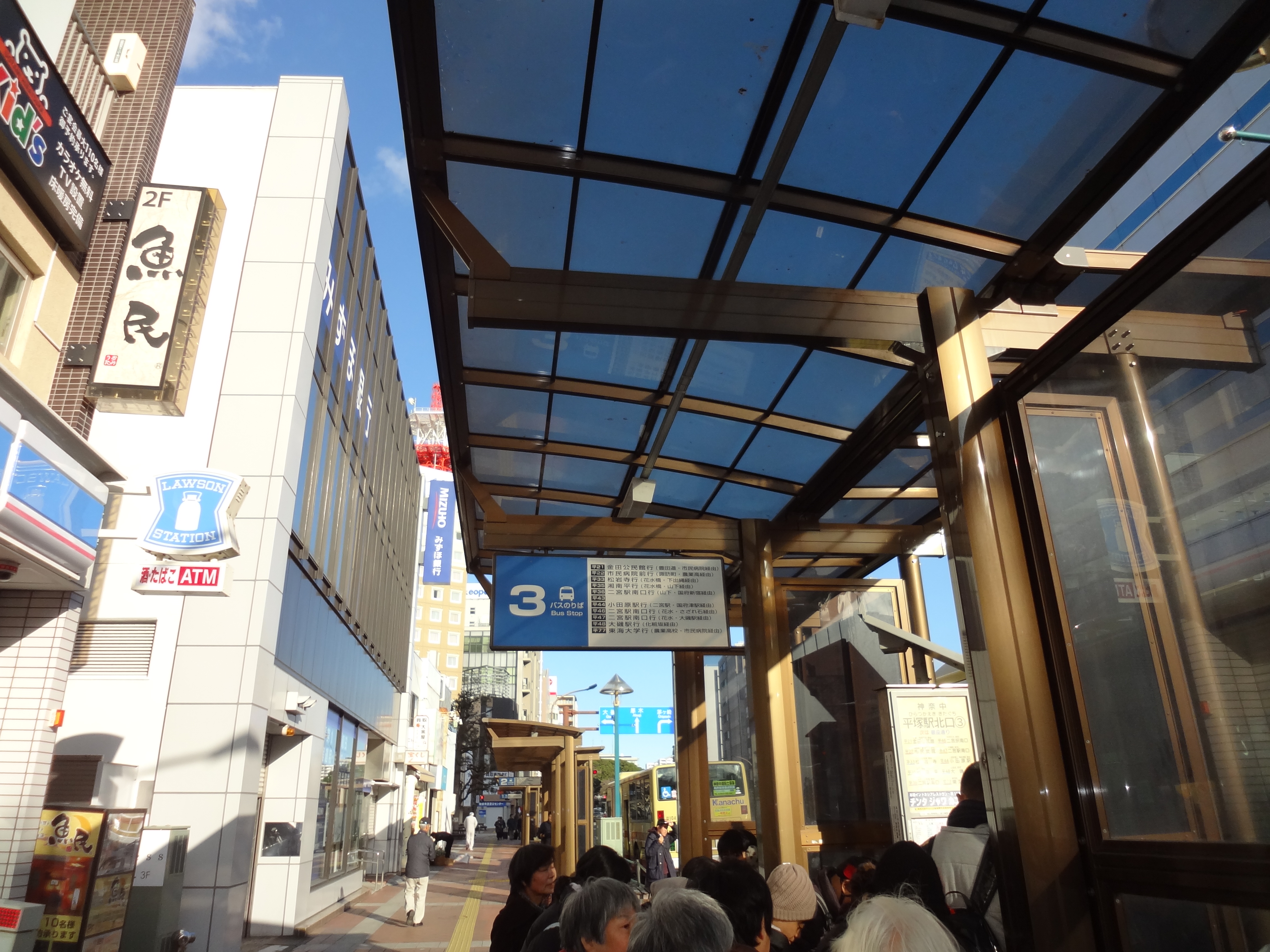
Actually, when you ask people of Kanagawa who are not so familiar with hiking, they will tell you Shonandaira is a dating spot with an ample parking space. The area called Shonandaira is a part of Komayama Park, with lots of amenities for tourists, including a restaurant, a shop, view spots, parking lots, and a TV tower. When you drive, you ask your car navigation system to Shonandaira, and you’re all set. Or, you take a Kanachu Bus Hira-35 平35 service (; time table is here) from Bus Stop #3 in the north exit of JR Hiratsuka Station, and go to the terminal stop, Shonandaira. The bus ride is for about 15 minutes. To walk around Komayama Park, this is the easiest way to enter the park as the rest of your itinerary is almost descending only to the beachside area. But if you prefer more active way of visit, starting from JR Oiso Station would be the easiest in terms of the condition of trekking roads. So, I tell you first how to reach to Shonandaira from Oiso Station on foot. (The map of the park is downloadable from here.)


#3 Bus Stop in front of JR Hiratsuka Station
Shonandaira, the terminal stop
The parking space at Shonandaira


From Oiso Station please take a narrow road along JR Tokaido Line to the direction of Odawara 小田原. In 5 or so minutes, on our left is Oiso Elementary and on our right there is an underpass. Please cross the train track by this tunnel and go straight. In 5 or so more minutes, on our right is Myodaiji Temple 妙大寺 where in its cemetery Dr. Jun Matsumoto 松本順, a person who made Oiso a celebrity town, rests in peace (; please see my post last week). Next to the temple there is an ordinary house which was once a residence of Taka’aki Katoh 加藤高明 (the 24th PM of Japan). Let’s turn right here on this corner of former PM house. Soon the road in the residential area goes up a steep hill that is behind the Oiso Station. This is the beginning of hiking course. We can see almost entire expansion of seaside downtown of Oiso. In few minutes we reach to a small park, or garden, called Takada Park 高田公園 surrounded by ordinary houses. From there, we can enjoy the views of Sagami Bay 相模湾, Mt. Hakone 箱根, and Mt. Fuji 富士山. The place has a public toilet. The next toilet spot is Shonandaira so that you can utilize the chance here!


JR Oiso Station: we go to the left in this photo.
Follow this road along the JR Tokaido Line, then,
Take the tunnel in front of Oiso Elementary.
The other side of the tunnel is like this.
Myodaiji Temple
This is where Dr. Matsumoto was buried.
Please turn right here.
Go straight and along the way …
meet a zig-zagging steep slope climbing up.
Oiso downtown seen from the route
Eventually,
 the road folks into a standard paved way
 and this pedestrian road.
 Pedestrian route is the short-cut,
 and safer without fear of car traffic.
Then,
 in front of us is a park where Tamotsu Takada
高田保,
 who was a famous cultural commentator
 and an Oiso resident around 1950, is buried.
 He loved the view of the ocean from there.


From the north of Takada Park, there is only one road which is first paved for residents along the way, then turns into a trekking road surrounded by forest. It is a ridge way but the most of it is wide enough for 1st graders walking safely. You may find the vegetation here is a bit different from that of, say, inland Hadano City. The area has lots of Machilus thunbergii, Castanopsis sieboldii, and Japanese camellia (Camellia japonica). They are evergreen broadleaved trees that love warm and humid atmosphere of seaside. When I’ve been there in last winter, bright red camellias dotted deep evergreens here and there. That was a fun. Deciduous oaks are minority. They, like jolcham oak (Quercus serrata), are surrounded by the evergreens, and often infected by Japanese oak wilt so that they are under the treatment of “chopping down” by the municipality. The oaks here are famous home for larva of beautiful zephyrus, Favonius orientalis (East Palearctic species of hairstreak butterfly). If there is no oak, what would happen to them here? Oak wilt in Japan was in the end due to human negligence of forest. Sure, they are large in Komayama Park, with the signs of early coppicing. They were once cared for harvesting fuel logs, and abandoned in the 1960s. We must remember this ...


The road from Takada Park is first like this.
 Please keep on going straight.
 The detour could make you commit
 a criminal offence of trespassing into a private property.
The trees here are certainly old …
We can enjoy the view of Sagami Bay along the route.
The road finally becomes a trekking road,
 and in last February at the beginning
 there was this notice asking caution for hikers
 as the municipality treat the infected oaks
 by Japanese oak wilt.
The map is shown here.
The ridge way in February
The route has several crossings,
 which become one eventually
 (except for one; please see below).
 So please take whichever way you like.
Poor oaks …
Yes. We’re hiking!
Eventually, a TV Tower is found over there.
 That’s our destination.


In fact, the forest of Komayama Park has been under the heavy influence of human activities for more than a millennium. We’ll see the first evidence of such human activity along the road from Myodaiji Temple. About 1km from Takada park, we meet a signpost showing a detour to “Yokokuji-yato Tunnel Tomb 楊谷寺谷戸横穴群.” Let’s go to see this archeological graveyard. Oiso Town has more than 1000 such ancient tombs build during the 3rd - 6th centuries. The soil of Oiso Hill is not difficult for digging a hole to make a resting place. Yokokuji-yato Tunnel Tomb is one of such places with at least 48 holes made during the 6th century. The place was regarded with some spiritual value, for sure. We’ll see what’s the result of such image for the forest soon, next week.


When I’ve been there last February,
 they were building this brand-new signpost
 to the way to the archeological site.
The way to the Tunnel Tomb is like this,
 surrounded by afforested cedar trees.
It goes down a bit …
To see these Yokokuji-yato Tunnel Tomb.
The excavated grave goods are now stored
 in Oiso Municipal Museum
大磯郷土資料館
 we visited two weeks ago.


Returning to the original road, a bit of climbing brings us to the main ridge way of Komayama Park. On our left, we can see a TV Tower, a sign we’ve reached Shonandaira. This is the main tower for terrestrial broadcasting to the western part of Kanagawa Prefecture. The lower part of the tower has an observation platform that is accessible by steps. If you like, you will go up and see the Pacific Ocean to the south, Tanzawa mountains 丹沢 to the north, Mt. Hakone and Mt. Fuji to the west, and downtown Yokohama and Tokyo to the east. But without climbing up that high, Shonandaira has lots of view spots to admire this panoramic view of 360°. The night view for Megalopolis Tokyo from Shonandaira is designated by enthusiasts as one of the “Best 100 Night Views in Japan.” No wonder why this is the popular place for lovers to drive. If you prefer having lunch with views during your hiking of Komayama Park, Shonandaira is the place, with lots of tourist’s amenities at hand. Bon appetite!


We’re getting nearer to Shonandaira.
The signposts are located strategically here and there.
 Please don’t worry.
Shonandaira
Tanzawa mountains from Shonandaira
Mt Fuji!
A restaurant and a shop are there.
Sagami Bay
To downtown area of Megalopolis Tokyo.
 Hmmmm.
 Yeah, it would be better admiring the view
 during night from here …


Next week, we’ll visit Mt. Koma 高麗山 of ASL 168m. The place is for lots of history. Please stay tuned!


If you find environmental issues in Kanagawa Prefecture, please make a contact with Kanagawa Natural Environment Conservation Center 神奈川県自然環境保全センター

657 Nanasawa, Atsugi City, 243-0121
〒243-0121 厚木市七沢657
Phone: 046-248-0323

You can send an enquiry to them by clicking the bottom line of their homepage at http://www.pref.kanagawa.jp/div/1644/