
About a
month ago, I chatted with one of my friends who lives near the Citizen Forests
Complex in the south of Yokohama. The conversation went like, “Now the season
of autumn is approaching …” “Yeah …” “Forests will be beautiful, won’t they?”
“Yeah …” “I envy you. It’ll be a fun to walk in the Forests near your home …”
“Oh, NO! People are flocking to my beloved places! Congestion!” I thought he
was exaggerating the situation. Well, Segami Citizen Forest is certainly not
Yokohama Station, but I found many, something of Kanazawa Zoo level, are coming
to enjoy the place, even though the road along the Segami Pond is closed due to
maintenance works. The 48 ha Forest occupies western part of 4 Citizen Forests
+ Nature Sanctuary + Zoo Complex in the south of the City of Yokohama. It has a
trekking road system of 6 km with 5 picnic open spaces (and one toilet). The
Forest became Citizen Forest in 1979 so that it is a well-established Citizen
Forest. Depending on your itinerary, you can enjoy your whole day in the
Forest, or make the place as an entry point to Hitorizawa Citizen Forest 氷取沢市民の森 to the east, or to Kanazawa Citizen Forest 金沢市民の森 + Nature Sanctuary 横浜自然観察の森 in the south. In 1988, the
entire area was chosen as one of the 50 beautiful forests in Kanagawa
Prefecture. No wonder it is a popular hiking destination among locals.

As
this map shows, the trekking road system of Segami Forest is something like centric
Paris. A quasi-circular ridgeway delineates Segami Forest from the residential
Higashi-Kamigoh town, Hitorizawa Forest, and Kanazawa Forest. The center of the
Forest is Segami Pond 瀬上池 that collects all the water from the surrounding valleys and releases it
to the north as Segami-sawa 瀬上沢 that is a tributary of Itachi
River いたち川. When we descend from any part of the ridgeway, we
reach to the Segami Pond. So the access to the Forest from “human world” must
reach to the ridgeway first, or go directly to the Segami Pond where a narrow
asphalt road reaches from outside. (No parking place, though.) The nearest
train station from the direction of Tokyo is JR Kohnandai Station 港南台駅 of
Keihin-Tohoku Line. From there, we can walk to the forest, or take a bus of
Kanachu Bus 神中バス. By bus, we ride from Kohnandai Station to Komyoji
Bus Stop 光明寺バス停 (港- Minato-35, 36, 37, 40, 85, 86: time table here, here, here, here, here,
and here) next to Momijibashi Stop もみじ橋バス停 for Kamigoh Forest 上郷市民の森 or Midorigaoka
Stop みどりが丘バス停 (港- Minato-93
Service: time table here). From Komyoji Stop, find a way to Shirayama Shrine 白山神社 where
a road climbs up to the Bato-no-oka Rest Area 馬頭の丘休憩所 (D5) of the west Ridgeway 尾根道 of the Forest. From
Midorigaoka Stop, you can either search for Shirayama Shrine, or take The
Ridgeway from the beginning that originates at the end of a complex of 8
building condos, about 200 m east from the bus stop. If you choose to visit the
Segami Pond directly, first go to Sakae High School 栄高校 from the Konandai Station
either on foot or by bus of Minato-85 and 86 services, or Minato-83 service
(time table, here). Find a road going south-west from the circular road
surrounding the school campus. This road crosses Segami-sawa. Turn left when
you meet the stream, and follow the paved road to the end which is the
Ikenoshita Plaza 池の下広場 (E3) of the Segami Pond.
 |
Ikenoshita
Plaza:
though it is currently a sort of construction area ... |
 |
| like
this. |
 |
| From
Ikenoshita Plaza, entrance to the east ridgeway |
 |
A climbing from Ikenoshita Plaza
to the west ridgeway leads us to … |
 |
| a
T-crossing of the Ridgeway (Map point D3). |
 |
| To the
right from D3 is Umanose Rest Area馬の背休憩所 (D2). |
 |
| D4
point to the Segami Pond is closed now. |
 |
Bato-no-oka
Rest Area (D5):
this gentleman was having a really big lunch! |
 |
A tiny
Hayagriiva at Bato-no-oka Rest Area.
It suggests this road was once a
commuter road
when people using horses for transportation.
It is an ancient
road. |
 |
The
Ridgeway is a border between
the residential area and the Forest. |
 |
| A Taiwanese
squirrel in the Ridgeway |
 |
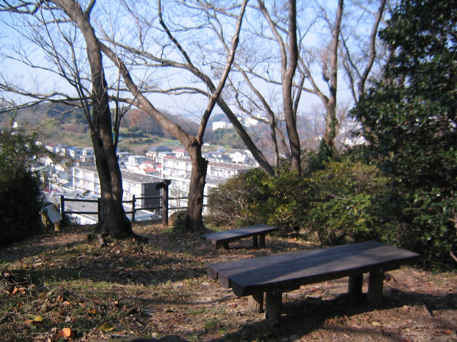
| Miharashidai
Rest Area 見晴らし台休憩所(D6) which is … |
 |
| supposed
to be a good viewing spot for Mt. Fuji … |
 |
The
Ridgeway of the Segami Forest
ends at Baitakusan Rest Area (D7)梅沢山休憩所.
The
Ridgeway beyond is Kanazawa Forest
we’ll visit later. |
 |
| To
Kanazawa Forest … |
Having
said that, I recommend you to approach to Segami Forest from the east ridgeway
which is a community road cum service road for radio relay stations in Enkaisan
Area 円海山. The reason is, before the entrance to the Forest, there is a wonderful
spot where we can see from the above the Segami Pond within a deep forest (;
the first photo of this post), and later, in a fine day, Mt. Fuji in its
elegant feature. In 2005, the place was chosen as one of the 100 best viewingspots for Mt. Fuji in the Kanto region. The approach there is first going to
Konandai 5-chome Traffic Light 港南台5丁目信号 which is the nearest Traffic
light to Sakae High School. (It’s about 3k from Konandai Station.) When you
come to this point from the JR Station, you’ll see Konandai Fire Station 港南台消防署 at
the opposite side. Cross the traffic light, and turn right at the corner of the
Fire Station. The road is a slow slope and you’ll find a billboard of the
familiar map for Enkaisan Area Forest Map ahead of you. There, it is a kind of
T-crossing, with one road goes down and another goes up. Take the road up. This
road skirts the farmlands around the Segami Forest on the right. Simply keep on
going until we reach to the Segami Pond viewing point. (There is a sign saying
so.) After enjoying the view, proceed along the road, and on the right we find a
Y-crossing which is E1 point of the map.
 |
| Konandai
5-chome Traffic Light |
 |
| Konandai
Fire Station. Take right here, then, |
 |
| Oh,
hello. |
 |
| This
way, please. |
 |
| And
keep going … |
 |
| beyond
is the View Point for the Pond. |
 |
After
the View Point, on the left is
first Konandai-saezurino-oka Park港南台さえずりの丘公園,
then
the garden of Konandai Hiyodori Housing Complex港南台ひよどり団地. |
 |
| We
have reached to E1! |
When
we take the road on the right at E1, we go down to the Segami Pond which has
Dojyomaru Plaza 道場丸広場 in the middle. Before the Plaza on the left is a private farmland behind
the trees. Dojyomaru Plaza is a tiny cozy space surrounded by camellia trees
with many colors. From there, the route descends down steeply to the Pond. On
the other hand when we take the road on the left at E1, we start to see on the
right with a wider slope of farmlands. This is the view point for Mt. Fuji. (Here,
also has a sign post for it.) Beyond the Mt. Fuji Point huge radio relay
stations start to appear on the left. (More for them for Hitorizawa Forests.) The
place where we meet the first relay station is A1 of the map. About 50 m into
the forest on the other side of the Tower, there is a toilet that is the only
toilet for Segami Forest. From the toilet, about 100 m ahead is a crossing with
Isshindo Plaza いっしんどう広場 (A2), where 4 roads meet to Hitorizawa Forest to the east, Segami Pond
to the west, and to the south Ridgeway. The Ridgeway is a part of popular
hiking course called Beetles Trail (; a-hem, yes, it is not “Beatles” Trail).
As such, Issindo Plaza is a kind of Shibuya Crossing, Times Square, or
Piccadilly Circus for hikers enjoying the Citizen Forests Complex.
 |
| To
Dojyomaru Plaza |
 |
| He has
an enviable career … |
 |
| Dojyomaru
Plaza |
 |
| To the
left from E1 |
 |
| It was
a fine day! Though … where are you Ms. Fuji? |
 |
| Just
proceed … |
 |
| A1 |
 |
| The
toilet for Segami Forest looks |
 |
| like
this. |
 |
Isshindo
Plaza,
just one chance to take a photo without people! |
 |
The
nature bulletin for Segami Forest in Isshindo Plaza:
it says at least weasels,
small Japanese moles,
and raccoon dogs call the place home. |
We
return to Beetles Trail when we visit Kanazawa Forest and Hitorizawa Forest. So,
today, I just tell you my experience for the roads descending down from the Beetles
Trail to Segami Pond. Although Beetles Trail is very popular, and we meet many
fellow hikers when we go there, going down to the Pond is a quieter affair. There
are 3 roads from the Trail to the Pond, all of which steeply go down. The road
from Isshindo Plaza to the Pond is the widest, and probably the least wet. In the middle of this route is Nakaone Rest Area
中尾根休憩所 (E2) with
a bench in the middle of mainly cypresses. The road runs on the ridge
descending to the Pond so that here and there both sides are very steep cliffs.
The undergrowth changes from shrubs around Isshindo Plaza to lots of ferns near
the Ponds. At the bottom, we cross a tiny stream coming out from the Forest and
pouring to the Pond. We enter the Ikenoshita Plaza at E5 where currently the
maintenance work is taken. A small river starting here is Segami-sawa. The
natural environment of the Pond and Segami-sawa has strong volunteer supporters
for preservation, named NPO Hotaru-no-furusato Segami-sawa Kikin (NPO Firefly
Habitat Segami-sawa Fund ほたるのふるさと瀬上沢基金). They strongly oppose the urban development
plan of the area by Tokyu Co. (Yeah, it is the developer that orchestrated the
massive house-pasting on the hills of Shishigaya Forest.) Let us see how the
movement evolves …
 |
| To
Nakaone Plaza |
 |
| The
bridge over the stream |
 |
| To the
Pond |
 |
| The
maintenance work, not development, is on-going. |
 |
| The
beginning of Segami-sawa |
Due to
the maintenance work around the Segami Pond, another two routes from the
Beetles Trail presently form a kind of circular route with the Urushikubo Rest
Area 漆窪休憩所 (E8) of the southern end of the Pond. Both of them have similar
distribution of vegetation as the road started from Isshindo Plaza; near the
Ridgeway is of evergreen needle-leaved trees with shrubs, and then with ferns
at the bottom. Half the way of the both roads is along the streams so that the
routes are far more wet and slippery. The way starting from A5 is steeper, narrower,
and along the indigenous habitat where Volunteer Organization Segami
Satoyama-mori no Kai 瀬上さとやまもりの会 takes care of. When we reach to the bottom, the place is a tiny wet land
nestles in the valley of Segami Forest. The road of wooden decks are prepared
for us to enjoy the quiet atmosphere with rustles … wind, trees, fallen leaves,
birds, stream … It would be more vivacious during summer with frogs, I guess. At
the end of the wooden decks is Urushikubo Rest Area which is currently
inaccessible due to the maintenance work. After the completion of the work, we
should be able to go to Ikenoue Rest Area (E9) and the Pond from there.
 |
The
road from A5 point
going down to the Pond |
 |
| A
water source along the road |
 |
| This
is interesting. |
 |
| … A
Jungle … |
 |
| And we
reach to the bottom. |
 |
| Urushikubo
Rest Area. Hm, OK. We’ll wait. |
From
Urushikubo Rest Area, We can return to Beetles Trail via Omaru Plaza 大丸広場 (E7) that is along another stream to the Pond. From Urushikubo,
first we climb up the somehow drier swamp within a wider valley. After climbing
up small steps, on the left is Omaru Plaza with several benches with a view of
the Segami Pond. The Plaza spreads along a stream. The trekking road is led by
the small natural hedge of moss J, and finally goes into the steps of logs. The road this side
between the Pond and the Beetles Trail is drier than the one down to Urushikubo.
It seems to me the Volunteers of Lovers of Segami Citizen Forest (Segami
Shimin-no-mori Aigokai 瀬上市民の森愛護会) do a good job for thinning and clearing the trekking road for the
safety of us. Thank you!
 |
| Around
the trek to Omaru Plaza |
 |
| Omaru
Plaza |
 |
| We can
see the Pond from Omaru Plaza. |
The
Segami Pond is like Etoile for Paris in Segami Forest, especially in terms of
the water system. Before, when satoyama around the Forest was busy for
agriculture, the Pond served as the main water source for the business. E.g. in
Jike Forest, Oh-ike 大池, and in Oiwake Forest, Dragonfly Pond とんぼ池. It was an important
tradition, called Kaibori かいぼり, all over Japan that once in
several years village people cleared such ponds by hands to prevent natural
sedimentation since if the ponds were gone, it was the end of agricultural
production of the village. This made the water system of Japanese traditional
village relatively clean with a larger biodiversity. The current maintenance
work for the Pond follows the tradition at least purpose-wise. It started this
September and is planned to be completed by the end of the coming March. The
work is to dredge the Pond, to study the current habitat of the system, and to
improve the trekking roads and the rest areas around the Pond. Along the way,
the City is capturing invasive species that drive the natives into extinction.
Last week, on December 12th, there was a session for Kaibori, open
for the public to see how the work goes. (I knew it just this week.) I think in
near future the City can disclose what they have found during the procedure in
the Pond.
 |
Segami
Pond from Urushikubo Rest Area,
taken with a selfie stick J. |
If you find a problem in the Forest, or want to call Volunteers,
please make a contact with
Office for the Park Greeneries in the
South 南部公園緑地事務所
Yokohama Municipal Government
Creative Environment Policy Bureau 横浜市環境創造局
Phone: 045-831-8484 (I guess in
Japanese only)
FAX: 045-831-9389 (I hope there is
somebody who can read English …)


No comments:
Post a Comment