
Let’s start climbing up to the peak of Mt. Oyama. First thing before anything is the golden rule to hike in Tanzawa. Never try off-road, but keep the route clearly marked by the park rangers. Tanzawa mountain is famous of its steepness and deepness. Although the region does not have so-high elevation, it’s easy to lose the way, and fall off the cliff once you wonder into the forest. Death is not so rare there. Besides, the eco-system in Tanzawa is very fragile. People in the know are struggling to minimize the tread pressure and its serious effects caused by visitors. (I’ll post about it later …) So please, please, please, behave well. Needless to say, no trashing. It’s our National Park! Also, consider the season and equipment when you go there. Checking the weather of your scheduled date is always the starting point of your itinerary. Thanks to the Global Warming, these days it is rare the high altitude area of Oyama is covered by 1m deep snow. Even though, snow can remain on trekking roads in March. Worse, they can freeze hard on a very steep ridge way. If you plan to go there during December-February, crampons are the MUST. It is definitely advisable to carry a good map of Tanzawa before your hike. For the most popular and reliable map, the info is here. … the map does not have Roma-ji … woops. I could not find a good English map for Tanzawa … The site of Japan Mountaineering Association aggregates the information of the mountains in Japan. Though they are mainly for the peaks of higher altitude, if something serious happens in Tanzawa they can cover. Consider leaving your hiking schedule in a written form at the entrance of the route. Tanzawa is the place where Japanese alpinists for Mt. Everest train themselves. Never underestimate the place.

To climb up Mt. Oyama, there are 4 routes … the 5th path coming from the north ridge is rarely used. It would be wiser to avoid the 5th path unless you’re an expert. The most frequented route is using a cable car service from Oyama Town to the Lower Afuri Shrine 阿夫利神社下社, an elevation of 700m, and then takes Omotesandoh 表参道 (of Oyama, of course, not that fashion district in Tokyo) … er, well, it’s a matter of opinion, but reading a 1/25000 map of Tanzawa, I think this approach might be the quickest, but the most steep climb to reach to the Upper Afuri Shrine 阿夫利神社上社, an elevation of 1252m. So in my post, I tell you my climb from Hinata Yakushi 日向薬師, Yabitsu Pass ヤビツ峠, and Kotakuji Temple 広沢寺, and going down via Omotesandoh and Urasandoh 裏参道. This week is my story from Hinata Yakushi to the peak.
 |
| Starting point |
From Hinata Yakushi and Sekiunji Temple 石雲寺 about which I posted 4 weeks ago, we proceed further into the mountain along the paved forest road. The route crosses Hinata River 日向川 and starts gradually climbing up. On the right, there is a restaurant + spa, Kurhaus Yamagoya クアハウス山小屋, where they serve gibier meats for lunch from 11:00. Next to the restaurant, there is a small open space that leads us to a trekking way crossing the Hinata River again to the remnants of Johatsuganji Temple 浄発願寺. The temple was completely destroyed by debris-avalanche in 1938. The route crossing the river is supposed to reach to the plum orchard of Hinata Yakushi … rarely used these days. Considering the reason for Johatsuganji to be annihilated, the road cannot be stable geologically. It would be wise to avoid the direction unless you dare. 200m or so ahead from Kurhaus, we’ll be greeted by a camping facility of Isehara City, Hinata Fureai Gakushu Center 日向ふれあい学習センター, which is in about 1 hour walk from the bus stop. Cars without permit cannot go further from here. On the foot of the Center Admin Building that is on the left of the forest road, there is an entrance to a hiking road, called Kujuku Magari (九十九曲 “99-times Winding Road”). It can lead us to the peak of Mt. Oyama. You can also continue walking the paved way to the end of the camping site, and from there enter a trekking road that eventually joins with the route starting from the Admin Bldg. This approach is twice as long as Kujuku Magari without merit of gentle slope, so I took 99-times hairpins to the peak! Oh, there is a VERY IMPORTANT info at this point. From there to the top (only during summer) or to the Lower Afuri Shrine, there is no toilet or potable water facility. In addition, for the reason of environmental protection, doing your personal hygiene outdoors is (at least legally) prohibited within National Parks in Japan. So, please complete whatever necessary for you at the Center before aiming to the top. The building has vending machines for drinks as well. You can leave your hiking schedule here. (Just in case … fingers crossed.)
 |
| Hinata River |
 |
| Kuahaus Yamagoya. They have a shuttle bus service from Hinata Yakushi Bus Stop. RSVP. (Phone) 0463-92-7750. |
 |
| The
space next to Kuahaus is commemorating the former site for Johatsuganji Temple. |
 |
| On the
left of the paved road is the admin of the municipal camp site. A small opening next to the building is an entrance to Mt. Oyama. |
 |
| The
entrance to 99-times Winding Road to the peak of Mt. Oyama |
After entering the hiking trail, the way soon crosses a small stream and begins a steep climb. The route then meets with the paved forest road which is off-limit without permit, coming from the end of the camping site. The point has signposts that let us turn our head to the continuation of the trekking way at the opposite side of the vehicle road. Generally speaking, this route to the peak of Mt. Oyama is well-equipped with signposts so that we can simply follow the direction, and keep our cool throughout the itinerary in the deep mountain. We ascend steep slopes from here, an elevation of 320m or so, for about an hour, surrounded by afforested forest of coniferous trees. This is Tanzawa that suffered massive landslides by 1923 Great Kanto Earthquake, and deforestation for the total war of WWII. After 1945, Japanese government subsidized foresters to plant as many as possible coniferous trees which were useful for reconstruction efforts. They did so here in a textbook way; the place near the stream was for cedars, and cypresses are to the higher elevation along ridges. At the beginning of the trekking route, we are surrounded by the forest of cedars where fallen branches of them thickly cover the forest floor. The cedars have around 40cm diameter uniformly … I guess they are 50-60 years old. (Oh, thank you for the Forest Instructor training sessions!) Within them, far thicker Pinus densiflora sparingly stands, or have fallen from the root. They must be the original residents of the area, before humans planted the cedars … Gradually, the cedars are replaced by cypresses whose small fallen leaves take over the ground cover from cedar branches. When we reach to the ridge way after 1 hour climb, there is an image of Jizo (Kṣitigarbha) sculptured in 1853 by a local artist, Amano Katsugoroh 天野勝五郎. So, this figure has the name, Katsugoroh Jizo 勝五郎地蔵. We have reached to the first mile stone, an elevation of 680m, to the peak of Mt. Oyama.
 |
| Let’s cross the river! |
 |
| The crossing with the paved forest road |
 |
| Here is the way to climb. |
 |
| A pine tree within the forest of cedars |
 |
| This
fallen pine blocked the trekking road so that somebody cut it off to make the way for us … |
 |
| We can
recognize the ridge over there, and the forest floor is covered by not cedar branches, but cypress leaves. In any case, have you noticed he vegetation of the floor is rather poor, even along the open space of the trekking road? That’s an indication of the ecological problem Tanzawa currently has … I’ll talk about it in my later post. |
 |
| Katsugoro Jizo. Please have a breath. |
 |
| The
warning against forest fires at Katsugoro Jizo. Could you see the number of the post, #4? It’s the number you should tell when you call fire departments. In Japan, the number is 119. |
From here, we enter a pleasant ridge way slowly gaining the elevation. The afforested cypress forest continues, but here and there start to appear not only Pinus densiflora but also huge Quercus serrata, vigorous Edgeworthia chrysantha, and young Fagus crenata Blume. In less than 30 minutes, we arrive at Miharashi-dai (見晴台 “the Lookout”), an elevation of 760m. Not for nothing the place is called a belvedere. From around here, we begin enjoying a spectacular view of Kanto Plain 関東平野 below us, though for the best view we must be patient until the peak … From Miharaishidai to the top of the mountain, an elevation of 1252m, it takes about 90min for a good walker. This is the final place before the peak for an ample space of picnic. Decisions, decisions … From here there is another route we can descend for half an hour to the Lower Afuri Shrine via Niju Shrine 二重神社 at Double Water Fall 二重滝. A round trip between Miharashi-dai and Lower Afuri Shrine is popular for visitors of “Oyama Lite” who don’t care to climb up steep slopes.
 |
| To Miharashi-dai |
 |
| What’s for these wire meshes? Er, it’s protecting the barks of young cypresses against … deer. Please remember we have met them here in Mt. Oyama … |
 |
| Magnificent Pinus densiflora! |
 |
| Final approach to Miharashi-dai |
 |
| It’s a mini-forest of wild Edgeworthia chrysantha. |
 |
| Miharashi-dai |
 |
| A beginning of the view |
 |
| To the Lower Afuri Shrine |
It is called Kaminari-no-mine O’ne (雷ノ峰尾根 The Ridgeway of Thunder-Peak) the ridgeway connecting Miharashidai and the crossing, an elevation of 1148m, with the road coming from Kotakuji Temple. It takes about an hour walk with a steep climb especially for the last 30min. In Shintoism, Mt. Oyama is a god of rain so that the rituals for Oyama often connect to prayers for rain. (Do you remember the underground spring in the Lower Afuri Shrine?) People believed Mt. Oyama is the god Oyamatsumi-no-Okami 大山祇大神 who is the father of many important gods in Japanese mythology, including the goddess Konohana-sakuya-Hime 木花咲耶姫 whose realization is Mt. Fuji … oh so beautiful and suitable for the best beau in the divine community. Many ancient place names in Oyama are for rain, thunder, and water. The afforested forest of cypresses disappears without notice, and we are surrounded by the forest of Fagus crenata Blume, with occasional Tsuga and gigantic Abies firma. It’s the sign we have passed the mark of 800m elevation. According to Dr. Jun Tamura 田村淳 of Kanagawa Nature Conservation Center 神奈川県自然環境保全センター, the native coniferous trees around the peak of Mt. Oyama are the survivors from the Ice Age and, later, environmental problems (which I tell you when we return to the things of deer). This place is the only remaining habitat for wild Abies firma in Kanagawa Prefecture. Beneath their arboreal gaze, the entire Kanto Plains with the Pacific Ocean become more and more clear. After having a lecture by Dr. Tamura, I begin to see the trees in higher places of Oyama with awe … They are silent, but very resilient and strong … Cool. No wonder our ancestors considered Mt. Oyama the place of god. Sure enough, sometimes we can meet groups of Buddhist monks who engage in walking meditation … er, well, some of them look simply enjoying hiking ... maybe they have reached Samādhi already …
 |
| The sign post is clear. So, take it easy. |
 |
| We need helps of chains in some place on this route. |

 |
| The
scientists install the equipment to study the environmental condition for trees. |
 |
| Monks in meditation … |
 |
| The
forest of Fagus crenata Blume and the others. If you can see problem in this picture, you know the thing. |
 |
| SagamiBay. Could you figure out Oshima Island over there? |
 |
| Go ahead, mate. |
 |
| The
crossing between Kaminari-no-mine O’ne and Kotakuji Temple Route |
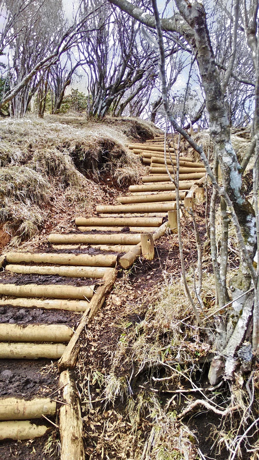
It takes about half an hour from the crossing to the peak, following the route of frequent wooden decks going up. Snow remains in March, and it’s better to be careful as the steps can be slippery. The forest is more and more of Fagus crenata Blume that are actually protected by the team of scientists lead by Dr. Tanabe. At an elevation of 1248m, there are toilets which are closed as long as the water is not warm enough. Near the facility is a modestly open space with picnic benches where we can enjoy the wide view of Kanto Plain. Considering the congestion at the peak of Oyama especially during summer, this place is convenient for hikers to find a place for rest. Going up the opposite direction of the toilet, we reach to the top of Mt. Oyama, an elevation of 1252m.
 |
| This wooden road is called “The Shoulder of Mt. Oyama. “ |
 |
| You see? The road is frozen … |
 |
| Snow in Mt. Oyama in late-March |
 |
| Nearly there … |
 |
| To the
right, toilet. To the left, the top of the mountain. |
 |
| A view from the toilet …(don’t say that!) |
 |
| Toilet closed due to frozen water. |
Woops, I’ve written this much already! Let’s keep the story about the top of Oyama and Omotesando for future. I’ll post about the hiking course from Yabitsu Pass next week. Actually, it’s a hidden, but the easiest way to climb to the top of Mt. Oyama!

If you find environmental problems in
Oyama, please make a contact to
Kanagawa Nature Conservation Center 神奈川県自然環境保全センター
657 Nanasawa, Atsugi City, 243-0121 〒243-0121 厚木市七沢657
Phone: 046-248-0323

No comments:
Post a Comment