
Oyama Afuri Shrine 大山阿夫利神社 has 2 campuses. One is the Upper Shrine 上社, which is on the top of the mountain. Another is the Lower Shrine 下社 that we visit in this post. Once you’ve experienced Otoko-zaka 男坂 and/or On’na-zaka 女坂, you may have realized why there is the Lower Shrine. The way to the Lower Shrine is steep enough. In Mt. Oyama, the higher the elevation is, the sharper the slope. In addition, until 1868 the main hall of Oyama Temple 大山寺 was at the location for the current Lower Shrine. Pilgrims to Oyama until then made the Temple their first destination to dedicate their wooden sword. After the Oyama Temple moved to the current site, the place was both spiritually and logistically good place to have the Lower Shrine, I guess. The most frequented route to the Shrine these days is using a cable car service from Oyama Town to the Lower Afuri Shrine 阿夫利神社下社, an elevation of 700m. There are lots of people who are happy enough to make a do at the Lower Shrine only. We can actually have a splendid view of Sagami Bay from the Lower Shrine. For New Year’s Eve and the autumn-leaves season, the town of Oyama has light-up events when they operate Cable Car at night. We can enjoy even the night view from the Lower Shrine during this period without risking night-time hike. The god of Mt. Oyama is generous. 😄
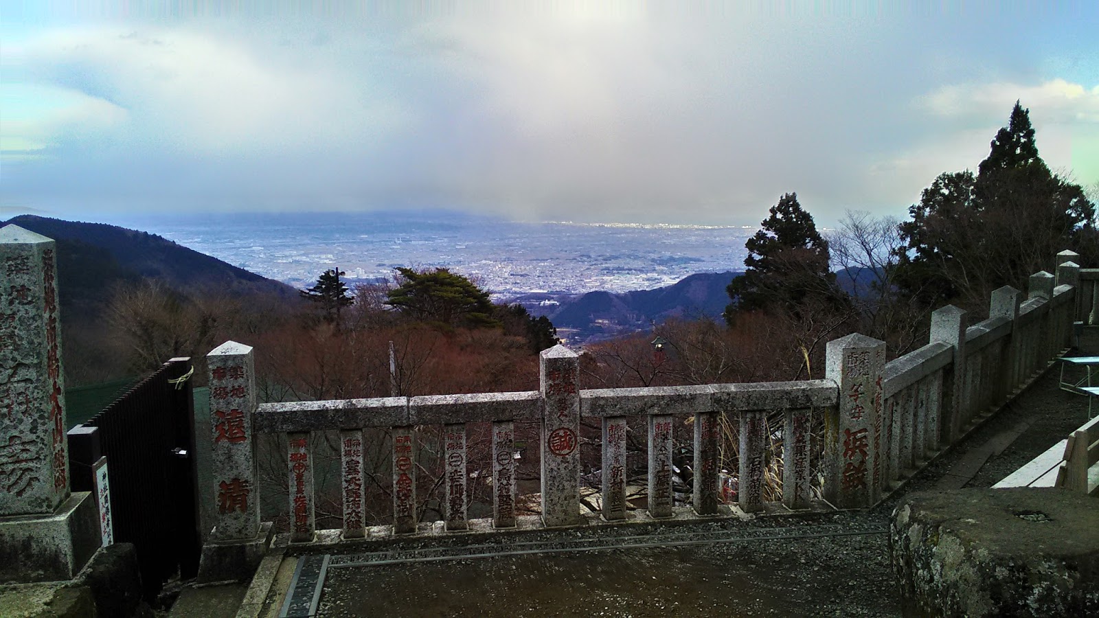 |
| A view
from the Lower Afuri Shrine to Sagami Bay and the cities along Shonan Beach. We can see all from Yugawara 湯河原 to Misaki 三崎. |
The campus of Lower Afuri Shrine is not so big. Whichever route we take from Oyama Town, we reach to the bottom of marble steps going up to the quasi-main shrine, called Haiden 拝殿, of the Lower Shrine. (The real main shrine is at the top of the mountain.) Around Haiden, there are 2 small shrines (Asama Yashiro 浅間社 and Ten’mangu 天満宮; I tell you about Asama Yashiro when we go to Yabitsu route later) and the other structures dealing with, er, business matters of the Shrine. You may notice the place is surrounded by stone fences of 70cm or so high. Each pillar has Chinese characters inscribed in a font similar to the ones found in Kabuki posters. The name of the font is Edo-moji that was originally designed during the 17th to 19th centuries. Those pillars have been donated by Oyama Koh 大山講 that are travel clubs organized by the pilgrim-wannabes. When the members of Koh visit the Shrine, they contribute to the construction works of the shrine’s and the temple’s structures. In return, they could carve the name of their Koh just like park benches in Central Park. The tradition goes strong in the 21st century. We can find brand-new pillars by reading the date engraved on the stone. I found many corporations for Tsukiji Fish Market 築地卸売市場 are donating to the Shrine, with their names inscribed on marbles in proudly vivid red. That would explain why we can feel the atmosphere of the Lower Shrine very vibrant, just like the daily morning auction in Tsukiji.
 |
| The Haiden of Lower Afuri Shrine |
 |
| The
frog says “Safe go home.” With these steps, the advice is appreciated. |
 |
| One of
the pillars is a donation from the “Class of 1964 of Oyama Elementary.” |
Between Haiden and talisman shop, there is a small opening that can lead us to the underground of Haiden. When we enter there, immediately we are greeted by a spring where we can collect “Pure Sacred Mt. Oyama Water” which is potable … I’m not sure if it’s truly a natural spring since no municipality in Japan legally allows distribution of unsanitised water as “drinkable.” But, it would be purified water (of the 21st century Japanese health standard) coming from Mt. Oyama who is the god of rain. If we come this far, why not bring the water home? In case you do not bring your own empty water bottle, don’t worry. The shrine is selling a plastic bottle, 200 yen, for water collection at the site. You proceed further into the basement, and there are exhibitions of old attire and wooden sword brought by yesteryear pilgrims, then a candle dedication shrine. There you choose your wish from a list of … er, I haven’t counted but surely more than 50 items, like “good health,” “finding a good lover,” “money,” etc. etc., and purchase a candle (300 yen) for each. Light a fire, leave it on the shelf of your wish, and you’ve done for asking. (Fingers crossed …) At the end of the underground corridor, there is a corner where we can have a sip of sake, without price tag but with a poster “Thank you for your donation.” … considering the locale, I donated a nominal amount in coin, and tasted it. Gooooooooood sake. Afuri Shrine has lots of patrons of sake makers (; their list is here). If Mt. Oyama presides rain, the deity is also for water, and hence, sake. Since 1947, Afuri Shrine has annual sake festival in May. This year, 26th of May is for general public older than 20 years old to join sake-tasting festival. Hic.
 |
| The
entrance to the underground corridor of Haiden |
 |
| I’m so sorry … the spring is out of focus … |
 |
| Candle ritual place |
 |
| And sake tasting corner! |
In the west of Haiden, there is a gate named Tohai-mon 登拝門 that is the beginning of real Mt. Oyama hike from the Lower Afuri Shrine. The route from Tohai-mon is called Omotesandoh 表参道 (of Oyama, of course, not that fashion district in Tokyo) that will be joined after 1K+ steep elevation by Urasandoh 裏参道 … well, it’s a matter of opinion, but reading a 1/25000 map of Tanzawa, I think this approach might be the quickest, but of the most arduous climb to the Upper Afuri Shrine 阿夫利神社上社, an elevation of 1252m. To climb up Mt. Oyama, there are 4 routes. Using Omotesandoh is one of them … In my posts from next week, I tell you my climb from Hinata Yakushi 日向薬師, Yabitsu Pass ヤビツ峠, and Kotakuji Temple 広沢寺, and going down via Omotesandoh and Urasandoh. Meanwhile, without reaching to the top, we can have a mini-hike from the Lower Shrine via a 1.5K road far gentler than those to the top (… it sounds very allegorical, doesn’t it?). It’s “Oyama Lite” to Miharashidai 見晴台 via Niju-taki 二重滝. The starting point of this walk is on the right of the bottom of marble steps, which is in front of you when you come from the Cable Car Station.
 |
| Tohai-mon, aka the beginning of Oyama Omotesandoh |
 |
| Here is the entrance for “Oyama Lite.” |
The beginning of the route to Miharashidai is almost identical to the stone steps of Otoko-zaka 男坂 / On’na-zaka 女坂. Then, the road becomes something similar to the trekking course we can find in Yokohama’s Citizen Forests: not scree-covered slope, but with moderate inclination. The difference between Yokohama’s Satoyama (里山 forests near human community) and Oyama’s Okuyama (奥山 otherwise forests) is, the valley of Oyama River 大山川. It is far deeper than that of, say, Hitorizawa Forest 氷取沢市民の森. Please be careful. The vegetation along the Oyama River around here and up is mainly primeval forest and designated as the Natural Treasure of Kanagawa Prefecture 神奈川県天然記念物 that should be protected. We start to see Abies Firma which, at the latitude of Kanagawa, typically grows in-between areas of Satoyama’s broad-leaved trees and Okuyama’s Fagus crenata. Oyama is the only remaining eco-system in Kanagawa Prefecture where we can find wild Abies Firma …
 |
| The
stone steps from the Lower Afuri Shrine to Miharashidai. When we go down there … |
 |
| The road is like this. Not bad, isn’t it? |
 |
| The natural treasure of us |
About 0.45K from the Lower Shrine, there is a small bridge over Oyama River valley. A notice board at the beginning of the overpass warns us. “Unless you cross this bridge concentrated with pure mind, you shall fall to the deep valley for death.” An alarmist’s advice for safe hiking? At the other end of the overpass there is a shrine called Niju Yashiro 二重社. This structure is situated right next to a double waterfall named Niju-taki 二重滝, and hence this designation. Though tiny, the shrine has a long history, and it was one of those purification sites for pilgrims, and Yamabushi 山伏. People believed the waterfall was actually a dragon deity, Takaokami-no-kami 高おかみの神, who is the main god of water appeared in Japanese mythology. It means, the power of this site was considered VERY strong. There is another explanation board next to the shrine, informing us before the GreatKanto Earthquake there stood a formidable cypress next to the waterfall which was used for Ushino-koku-Mairi 丑の刻参り rituals. … This is a kind of black magic in Shintoism. When a sorcerer wants to kill somebody by cursing, s/he wears white kimono and iron tiara decorated by lit candles, and visits a sacred tree in a shrine during AM1:00-3:00, “Ushino-koku” in old Japanese time, for 7 consecutive days. There, a necromancer nails a doll made of straws on a sacred tree with incantation for 2 hours. The doll is a substitute of a person incurred the enmity, and the place nailed down is believed to be hurt in the real body. If somebody saw the operation, that person must be killed by the sorcerer. If the jinx fails to be executed for 7 uninterrupted nights, the death comes in return to those who curse. In short, it’s a horrible magic, and I now understood the meaning of the post before the bridge … When somebody must have come this deep in the forest for such a purpose, how was the desperation that person felt … 50m or so from the shrine on the left, there are 2 large trees decorated with Shimenawa 注連縄, i.e. sacred trees near the shrine. Are they for the purpose? No way …
 |
| The bridge with forewarning |
 |
| Niju Yashiro |
 |
| Niju-taki. It was dry when I’ve been there late March. No cypress. (Relieved …) |
 |
| At least I haven’t found any doll on them. |
From Niju Yashiro, the road runs along the contour of a deep and steeply forest composed of large trees. Here and there, the edge of the forest and the road reveals the soil of Tanzawa that is rocky with shallow soil. It’s understandable why this area suffered massive landslides by Great Kanto Earthquake … Nonetheless, the huge trees have kept standing for millennia … Cool. The route starts to climb with hairpin curves, and soon, we reach to an opening, i.e. Miharashidai. On the right there is a gazebo, and on the left are picnic tables looking the southeast of the Mt. Oyama. “Miharashidai 見晴台” means “the platform with a view.” Certainly. From this point, we can figure out downtown skyscrapers in Yokohama. Although it’s not so spectacular as the views from the peak, the scenery from Miharashidai is a good deal after not so demanding trekking road. Yet, when we look up, the peak of Mt. Oyama, which is supposed to be in the northwest from Miharashidai, is shielded by the forest. Well, it’s time to go up!
 |
| Keep walking, but no grudges, pls. |
 |
| Wow |
 |
| The
route is well-maintained. As long as you stay on track, you’ll be OK. |
 |
| One
more bridge to cross a gorge. I didn’t find a magic site here. |
 |
| Why must
this tree choose this point to grow? … or the boulders came later? |
 |
| When you
start to climb more forcefully, and the trees become neatly lined (i.e. forested) cedars, it’s the sign Miharashidai is very near. |
 |
| Just
before Miharashidai, there is a warning about … bears! |
 |
| Miharashidai picnic space |
 |
| Spring
is hazy season in Kanagawa … could you recognize the Landmark Tower over there? |
 |
| In
Miharashidai. “To the peak, 2.25K. To Hinata Yakushi, 4.2K.” |
Oyama Afuri Shrine 大山阿夫利神社社務局
355 Oyama, Isehara City, 259-1107 伊勢原市大山355
(phone)
0463-95-2006
If you find environmental problems in
Mt. Oyama, please make a contact to
Kanagawa Nature Conservation Center 神奈川県自然環境保全センター
657 Nanasawa, Atsugi City, 243-0121 〒243-0121 厚木市七沢657
Phone: 046-248-0323

No comments:
Post a Comment