
Kanagawa Prefecture has 5 large dams (Miho 三保, Sagami 相模, Shiroyama 城山, Doshi 道志, and Miyagase). Miyagase Dam 宮ケ瀬ダム is the only dam in Kanagawa built and managed by national government. It is a concrete gravity dam constructed for 30 years with 397 billion yen (USD 3.97 billion). The Dam became operational in 2001 as the youngest and the largest of the 5 dams of Kanagawa. Actually, it is the third tallest dam in Japan. Inevitably, it prides itself made of the latest and environmentally friendly technology. Miyagase Dam sits in the center of water distribution for our prefecture. Roughly 61% of Kanagawa’s water comes from Sagami River 相模川, via two intake weirs, Sagami-ozeki Weir 相模大堰 and Samukawa Weir 寒川取水堰. H2O from the two weirs is distributed mainly to the east of Kanagawa Prefecture, Yokohama inclusive. (I’ve mapped the locations of these dams and weirs here.) In normal times, H2O from Sagami River is stored in Sagami and Shiroyama Dams. When these 2 old dams have lower reservoir, Miyagase kicks in by two ways. One is discharging water via Nakatsu River 中津川, a tributary of Sagami River. Another is via an underground aqueduct from Lake Miyagase to the mouth of Doshi River 道志川 pouring into Lake Tsukui 津久井湖 at Shiroyama Dam. When draught problem is non-existent, Miyagase collects water via another underground aqueduct from Doshi River to Lake Miyagase. Although its catchment area is the smallest among the 5, Miyagase’s largest reservoir capacity acts as a reservoir of reservoirs for Kanagawa’s water system. I think this is a very luxurious arrangement for maintaining stable supply of tap water. This is one of the reasons why we in Kanagawa have fewer draughts. In addition, as it’s a dam of the 21st century, Miyagase Dam has many tourists’ attractions deliberately provided from the beginning. 😉 Let’s visit the place this week.
<Main dams in Kanagawa Prefecture>
|
|
Operational since
|
Reservoir Capacity (m3)
|
Dam Height (m)
|
Crest Length (m)
|
Basin Area (km2)
|
Catchment Area (km2)
|
|
Miho
|
1978
|
64,900,000
|
95
|
587.7
|
158.5
|
158.5
|
|
Sagami
|
1947
|
63,200,000
|
58.4
|
196
|
1201.3
|
1201.3
|
|
Tsukui
|
1965
|
62,300,000
|
75
|
260
|
||
|
Oku-Doshi
|
1955
|
1,525,000
|
32.8
|
74
|
112.5
|
112.5
|
|
Miyagase
|
2001
|
193,000,000
|
156
|
375
|
213.9
|
101.4
|
 |
| As tourism promotion, they have several pamphlets about the area written in English, Korean, and Chinese. |
 |
| 2 kinds of tourists’
trolley service are in operation around the Dam. The detail can be seen here. |
To go to Miyagase Dam, the easiest is by car. Lake Miyagase created by the dam has lots of tourists’ spots with lots of parking spaces. Setting your car navigator to Miyagase Dam, and you’ve done. The parking of the Dam is for 9 cars conveniently right next to the dam museum. Admission for the museum is free, and everywhere allows wheelchair access. Having said that, the area is popular tourists’ destination, and sometimes we have to endure traffic jams. (Please see this notice from the Dam Admin Office for 2019 season.) If you can, I recommend you to (1) leave your car in a larger car park of Prefectural Aikawa Park 県立あいかわ公園 and walk the way I tell you below from the nearby bus-stop, or (2) visit Miyagase Dam by public transportation. Strolling from the bus stop to the dam museum is very refreshing, and interesting to see the working of Miyagase Dam, actually.
 |
| A parking space next to the dam museum |
By public transportation to Miyagase Dam, please take 30 minutes bus ride with Kanacyu Bus 神奈中バス from Odakyu Hon’atsugui Station 小田急本厚木駅. Leaving from the North Exit of the Station, you find Bus Stop #1 in front of you. Catch services Atsu-01 厚01 or Atsu-14 厚14 (time table, here) to Hanbara 半原, and get off at Aikawa Oh’hashi Bus Stop 愛川大橋. The bus stop is on a bridge over Nakatsu River. Find a way to go down to a narrow community road running under the bridge. Start walking to the mountains in the west. After about 10 minutes or so, you’ll be greeted by a folk crossing with a gate. It’s an entrance to Prefectural Aikawa Park and the Dam. If you take a path to the right, you enter Aikawa Park with an ample parking and a museum commemorating communities flooded by the dam. You then meander inside the Park, gradually climbing to the crest of the dam with the dam admin office. To the left from the crossing, we first meet with Ishigoya Dam 石小屋ダム that is a small, but very important concrete gravity dam for Kanagawa’s water supply system.
 |
| The north exit of Hon’atsugui Station |
 |
| #1 Bus
Stop. During weekends, it’s a very busy bus stop with tourists. |
 |
| Aikawa Oh’hashi Bus Stop |
 |
| Next to the bus stop, they provide a tourists’ map. |
 |
| Proceeding
to the same direction of the commuter bus a bit from the bus stop, we can find this steps going down. Just take it, and |
 |
| we’ll
be greeted by this sign showing us to the Park and the Dam. |
 |
| It’s a straight commuter road to the mountain … |
 |
| The
gate is at the end of this photo. If we take the road on the right, we’re straight into Aikawa Park. |
 |
| Prefectural Aikawa Park observed from Ishigoya Dam |
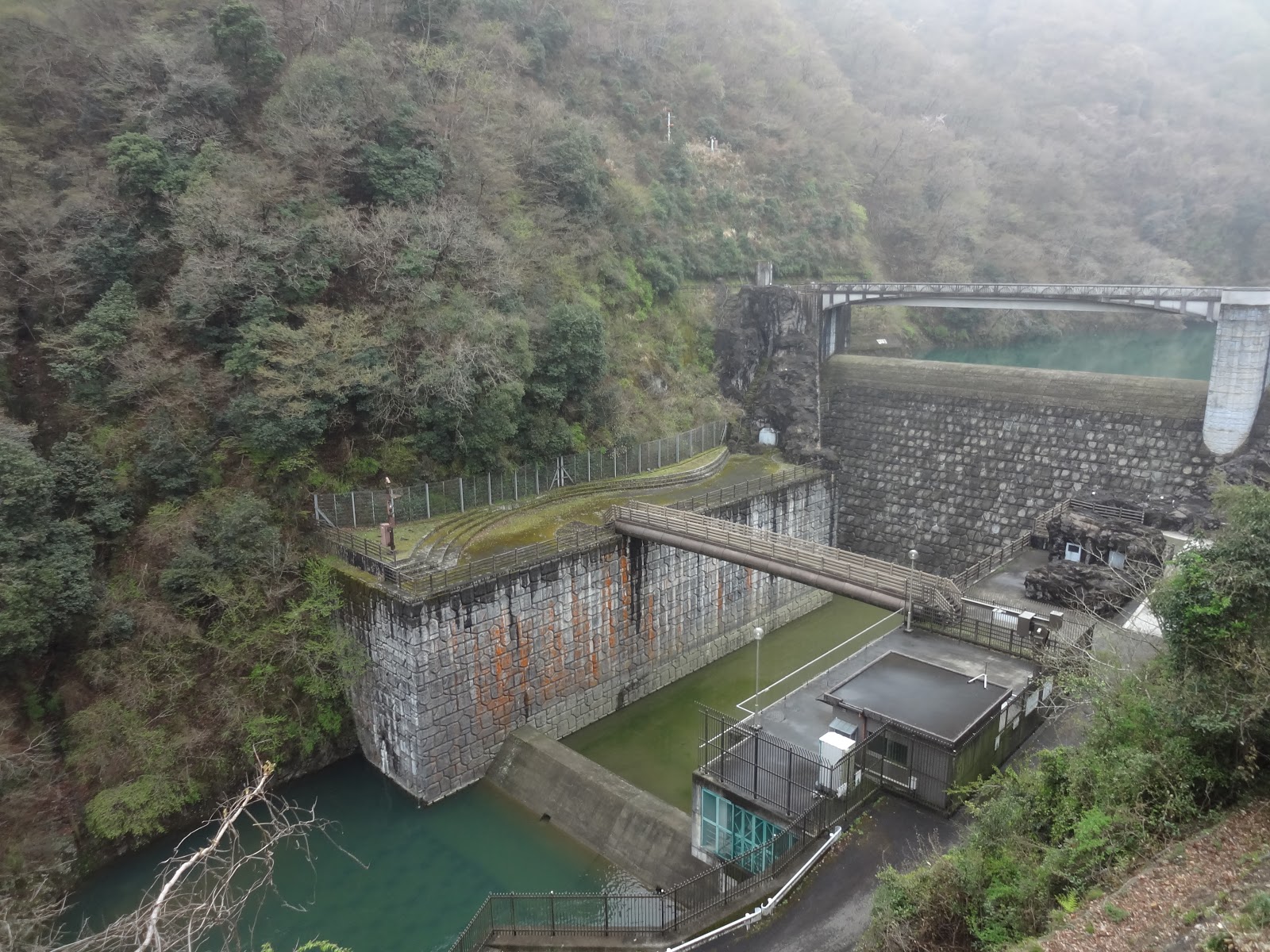
To Ishigoya Dam, it’s a quiet stroll. On our left deep down there is a gargling valley of Nakatsu River where we can see so near steep slopes of the other side of the valley … really deep eastern Tanzawa 丹沢. Soon, we find a small dam with a matching color scheme, dark brown, to the environment. It’s Ishigoya Dam, an auxiliary for Miyagase Dam. The dam acts as a buffer to help Miyagase controlling water supply. First, the aqueduct going to Lake Tsukui starts from here. Second, when Miyagase discharge water, H2O is first stored here, and released gradually to Nakatsu River. It prevents flush floods from gigantic Miyagase. From the Dam to downtown Atsugui City 厚木, it’s only 15km. Not only Atsugui, but downstream of Sagami River has cities of Sagamihara 相模原, Chigasaki 茅ヶ崎, Hiratsuka 平塚, and the other towns where roughly 20% of Kanagawa’s population live. Flood control is very important job for Miyagase and Ishigoya Dams, you see? The shores of Ishigoya Dam are constructed by blocks molded by outer precast shells. It is to preserve the scenery of old Nakatsu Stream before the Dam. One way to be environmentally friendly …
 |
| The
road from the gate is like this. Take the left road over there. |
 |
| The
slope of the mountain looked so near early morning of March. Beautiful … |
 |
| Ishigoya Dam |
 |
| The
slope here is artificially “rocky” for recalling the former landscape of the area. The place once had popular mountain cottages for alpinists. Could you see a small building on the left? It’s a power plant generating electricity distributed to TEPCO. |
 |
| The mouth of the aqueduct going to Doshi River |
Seeing the gate for the aqueduct on the left, on the right is a “train stop” for tourists’ trolley service going to the attractions of Lake Miyagase. The well-paved road slowly curves around the foot of Aikawa Park. Following the way, suddenly, a gigantic concrete wall appears in front of us. It’s Miyagase Dam. The dam itself is impressive enough, and the management prepares another attractions here. From April to November, every Wednesday, 2nd and 3rd Friday, 2nd Sunday, and on the special event days, they discharge water twice a day for 11:00-11:06 and 14:00-14:06. (2019 calendar for discharge is here.) Anybody who comes this far can see the spectacle, free of charge. The difference in elevation of the artificial water fall is 70m and the amount of water is 30m3 per second. That’s something to see, especially during dead-hot summer. Aside from contributing tourism industry, flushing water periodically can clean up the river bed of Nakatsu and Sagami Rivers that have in the end smaller water flow compared with the time without Miyagase Dam. Reduced water of not much stream worsens the ecosystem of a river running through populated area. The Dam equips a high-tech selective weir system that can choose the depth of water intake from the Lake (; we can find it from the crest). The water discharged is collected at the best depth for suitable temperature of the environment in downstream. It is said that ecosystem of those rivers are improving with the flush. Civil society organizations, regional and national governments and academia are yet monitoring the condition of Nakatsu and Sagami Rivers with discharge ...
 |
| Around
the corner of the curve to the Dam, they have this exhibit explaining underground aqueducts between Lake Miyagase and Doshi River. |
 |
| The yard for tourists’ trolley on the right, and |
 |
| the Dam is over there. |
 |
| We cross the bridge over the lake created by Ishigoya Dam. |
 |
| From
the bridge, on the left, we can see Ohsawa Fall 大沢の滝 which was one of the attractions for the people to come before the dam. |
 |
| Miyagase Dam |
 |
| Another
power plant in front of Miyagase Dam. Er, well, this is the main power plant for Miyagase Dam sending electricity to the grid of TEPCO. |
 |
| In
front of the Dam, there is a bridge. I guess this point would be super-congested when they discharge water … It’s the best spot for your Instagram. PLEASE Do Not Lean on the Parapet Here! |
From here to the crest of the dam, there are 2 ways to climb. One is by Incline that was a facility used during the construction, and now is a cable car with a view for tourists. Rtn. ticket fees: Adult, 500 yen (300 yen for one way); kids of 1st to 6th graders, 300 yen (200 yen for one way); toddlers, 150 yen (100 yen for one way). The service surely has a spectacle especially during discharge. Though, if you prefer a cheaper option, there is an elevator, free of charge going from the inside bottom of the dam. Although there is no vista at all from the elevator, walking to the elevator in a long and narrow concrete tunnel could be another attraction. 😁 When you take an elevator, you come out to the center of the crest. In front of us there are 4 towers on the Lake side. The fourth structure to the south is a huge machinery of selective weir system in which the mobile mouth of water intake goes up and down for the best depth of H2O. Top of the crest certainly has a picture of Lake Miyagase to the west, and the downstream from the dam to the east. In order to minimize the impact of dam building on ecosystem, they first drained rivers and streams with provisional water tunnels, and used river beds as construction roads. After the completion, those beds were flooded. So, at the bottom of the lake must have the remains of roads ... To the north west of the dam is a remnant of a hill where they excavated concrete aggregate. Now the slope of the hill is covered by young broad leaved trees afforested at the time when the dam construction was over. The seedlings were harvested from the mountains surrounding Lake Miyagase, expecting the original vegetation recovers quickly. To the north from the elevator, there is an observation tower to see such scenes from a higher point. Weather permitting, it is possible to figure out Tokyo Skytree, Mt. Hirugatake 蛭が岳 and Mt Fuji from there.
 |
| The
station to catch Incline. Another entrance at the bottom in the photo is to the elevator. |
 |
| The cable
car goes up this rail to the station at the crest, right next to the dam museum. |
 |
| To the elevator, we enter here, and just go straight … |
 |
| along the very long tunnel. |
 |
| At the
end of the passageway, there are steps going up to … |
 |
| the entrance for the elevator. |
 |
| This is the selective weir. |
 |
| We can
see the structure of the weir on the right. Could you see the slope over there? That’s where afforestation was done after collecting concrete aggregate. |
 |
| A wide
crest of Miyagase Dam. The building over there is a museum. |
 |
| My
view from the observation tower to Tokyo … It was raining … |
The administration office of the dam sits in the north of the crest of Miyagase Dam. When you go up from Aikawa Park, you come here eventually. The south of the crest of the Dam is a museum named “Water and Energy Museum” 水とエネルギー館. It’s a fun museum with lots of interactive exhibit explaining Miyagase Dam and water supply system in Kanagawa Prefecture. The place also has a café so you can have lunch here. Well, important info. For Dam Card of Miyagase and Ishigoya Dams, we can go to the reception desks for either Admin Office (8:30-17:15, M-F, except New Years’ Holidays) or the Museum (Tu-Su, except New Years’ Holidays, 9:00-17:00 April-November, 10:00-16:00 December-March). Very very important Info. Between February 24th and May 31st, 2019, Japanese dams managed by the national government distribute special version of Dam Cards commemorating the 30th anniversary of His Majesty the Emperor’s Accession to the Throne. As you can see them from here, the design of the memorial cards have, I would say, a noble color, compared to standard versions. When I visited the museum recently, there was a line before the door opening for the cards. And, of course, I joined the cue. Gotcha!
 |
| Looking
to the north on the crest. The building at the end of the boulevard is the admin office. The building on the right is exit from the Incline. |
 |
| Water and Energy Museum |
 |
| Kids can do coloring in this room. |
 |
| An interactive panel explaining Kanagawa’s water system |

 |
| It’s a
sci-fi … actually, this is a replica of water pine running inside the dam for discharge. |
 |
| We’re for cards! |
The area of Miyagase Dam and Lake Miyagase is developed from the beginning to sustain themselves by tourism. So, there are many places to go, even when we limit ourselves to forests. I will tell you my adventure there by and by. Meanwhile, a person who has worked for Japanese dams recently told me. “Naomi, you see? Those dams are said to be last for at least 100 years. It’s true they were built by the most advanced technology at the time they were designed, and expected to stand for a very long time. But that “100 years” do not have any endorsement of civil engineering. It’s simply an accounting gimmick for the mandarins of Ministry of Finance to present cost-benefit analysis to the Diet to pass the budget. No one actually knows 100 years are reliable time-scale. And, see? How about the effect of large earthquakes and volcanic activities? Will they endure still 100 years? If not, and an edifice needs overhaul, not small mending here and there, how can we do it? And what happens after 100 years?” Hmmmmmmmmmmm. The gigantic concrete wall of Miyagase is still a teenager. But it will surely be an old guy, like Sagami Dam. When the time comes, Dam Card with Emperor’s commemoration I’ve collected might have a different value … I keep crossing my fingers such day would come in far distant future. Perhaps, then, humans know how to fix large complex edifice without much fuss. The afforested slope then would have large deciduous trees, of the next generations, perhaps. I do hope so.

Broad Area Dam Management
Office for Sagami River System, Kanto Regional Development Bureau, Ministry of
Land, Infrastructure, Transport and Tourism
国土交通省 関東地方整備局 相模川水系広域ダム管理事務所
2145-50 Aza-Minamiyama, Aoyama, Midori Ward, Sagamihara, 252-0156
〒252-0156 神奈川県相模原市緑区青山字南山2145-50
Phone: 046-281-6911, FAX: 0465-78-3371


