In the City of Yokohama, there are 3 Prefectural Park of Kanagawa. All of them are not far from JR East train stations. Access to them is not bad. Among these, Hodogaya Park 保土谷公園 (near JR Hodogaya Station 保土ヶ谷駅) and Mitsuike Park 三ッ池公園 (near JR Tsurumi Station 鶴見駅) are typical urban parks with sports facilities opened during the 1950s. The vegetation down there are “constructed” as garden. The third, and the newest (in relative terms), is Shikinomori Park 四季の森公園, opened in 1988. For landscape design, 30-years of difference in inauguration is perhaps definitive. Unlike the two older parks, Shikinomori Park is “managed” Satoyama forest of 45.3ha. Yesteryear’s usage of land in a traditional agricultural village is preserved to some extent. Artificial deployment of plants is not much. It locates next to Niiharu Citizen Forest 新治市民の森. So, it becomes the northeast corner of Yokohama’s North Forest Area. This week, I tell you my leisurely adventure in this well-manicured nature park … Oxymoron?

The easiest access to Shikinomori Park is from JR Nakayama Station 中山駅 of Yokohama Line 横浜線. We leave the station from the South Exit, and take a road going south from the corner of McDonald’s. Soon, we’ll meet a traffic light named “Nakayama Station South Exit Entrance 中山駅南口入口” at Prefectural Road #109. Cross #109 and turn right to walk 10 meters or so. On our left, there is an entrance to a small road diving into a residential area. It’s the “Promenade to Shikinomori Park.” Let’s take this one, about 850m long pedestrian way to the Park. Eventually, the route goes along a small watercourse. The water flow is the characteristics of Shikinomori Park … Before long, there is the North Entrance of Shikinomori Park. This side of the Park does not have a parking. If you drive, please go to the South Entrance of the Park. It opens 8:30-18:00 (May-September) or 8:30-17:00 (October-April), free of charge during weekdays, and 530 yen (or 100 yen for motorcycle) for holidays. It has spaces for 165 cars!
 |
| The entrance to the Promenade to Shikinomori Park |
 |
| Half the promenade runs along this small stream. |
 |
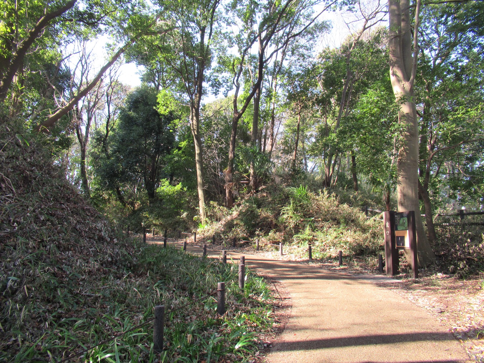
| The North Entrance of Shikinomori Park |
 |
| The South Entrace of
Shikinomori Park. “Parking = P” sign is there. |
 |
| Parking space is ample. |
The Park spreads over slopes of tiny valleys (; the map is here). North Entrance is at the point where these small flows gather to be ponds. Before the place became a park, it was used for rice cultivation. Rumors say the landlords paid their inheritance tax by land to the prefecture … South to southwest of the Park, the ridge of the valleys, is large housing complexes in Hikarigaoka ひかりが丘団地. Those places were developed before the Prefecture made the area a park. People in the housing community have used the place as a shortcut to JR Nakayama Station. Shikinomori Park continues to be a part of community roads for locals. Thus, we can meet a lot of people always there. In Shikinomori Park, many roads are paved or with wood decks. You don’t have to wear hiking boots. Good town shoes would be enough. The place also has several toilets and vending machines for drinks. At the parking, they have a small shop selling snacks and ice creams. The place is well-equipped. With this COVID-19 thing, the Park becomes popular more and more.
 |
| Hikarigaoka Housing Complex, next to the ridgeway of Shikinomori Park |
 |
| The commuters’ way in the Park from Hikarigaoka to Nakayama Station |
 |
| At the North Entrance, there are an admin office and a small meeting building. Unfortunately, the meeting places inside the park are now closed due to COVID-19. |
 |
| A shop next to the parking sells sweets and soft drinks. |
Next to the parking, there is a garden with a large fountain loved by local toddlers, especially in summer. From there a tiny hill goes up to the point with a viewing gazebo, the highest point of the park (ASL 41m!). Next to the gazebo there is an entrance to a large slide going down to a playground with equipment, near to the North Entrance. All are immensely popular among kids. If your family plans to play there, you’d better bring cardboard boxes to use as a cushion for slides. Next to the playground is a field and a constructed small valley. The field is ideal for families to pitch tents for picnic. During summer weekends, many parents came here for a nap while their kids are playing around. The artificial valley is called “Jabu-jabu Ike じゃぶじゃぶ池 (Splashing Pond)” where kindergarteners can play in a very shallow water during summer. Now the management is doing the maintenance job there and we don’t know if we have access to this very popular spot this summer … I suspect the prefectural office plays safe to stop crowds gathering for summer with corona virus … Er, well, the Park has rules. No BBQ or fireworks; No playing with balls like baseball, tennis, football, golf, et al; No bike (except that for kids with training wheels), motorcycle, or car; No skateboarding or roller skating; No trashing or vandalism; No smoking. The regular things, you know. In addition to this, the management these days broadcasts regularly warnings via loudspeakers in the forest. “Please do not congregate even you are in open space park. Maintain proper social distance. Wear masks whenever you speak to your fellow stroller. Please wash your hands with soap. Thank you.” *Sigh*
 |
| The fountain and the kids |
 |
| ASL 41m is there. |
 |
| The slide goes down … |
 |
| The playing park in April 2020. It was closed due to the State of Emergency against COVID-19. It’s now open. 😃 |
 |
| The field where families can
pitch tents. We can see the playing park over there. |
 |
| Jabu-jabu Ike. It’s dry now due to the maintenance work. |
Even with Covid-19 alert, Shikinomori Park certainly has a capacity for visitors. Many trees of the Park are of oak family, like bamboo-leaf oak (Quercus myrsinifolia), sawtooth oak (Quercus acutissima) and jolcham oak (Quercus serrata), which were once used as fuels of daily life. It seems to me they are at least 40-50 years old with signs of coppicing that was done ages ago. I guess before landlords sold their property to the Prefecture, they have long abandoned the management of their forest … In a sense it was fortunate the place becomes such a popular park with always-many visitors, under proper forestry. If you prefer “wild” atmosphere of forest, please try Area 7 or slopes beyond Area 6. As trees are old for Shikinomori Park, these areas still have damaged large trees due to severe storms last year. Several routes are closed. Even though, the roads are definitely wider and safer compared to, say, roads of the next door Niiharu Citizen Forest. If you seldom visit natural forest in your life, Shikinomori Park is a good place to begin.
 |
| Wood deck is constructed along the pond. |
 |
| The other side of the pond is
like this. No need for hiking boots, for sure. |
 |
| Unpaved parts of the Park. Well-maintained. |
 |
| Some roads are closed due to the storms last year. |
Area 7 is called “Sakura-no-tani 桜の谷 (Cherry Blossom Valley)” that is along busy Nakahara Street 中原街道. It’s amazing at the bottom of the Valley, incessant traffic noise of Nakahara Street sounds far away. The network of the road for the area lets us walk around. Not many people come here even with COVID-19. It’s a good place to feel solitude in city with well-equipped roads. The western part of the Valley has preserved rice paddies used for educational purposes to the neighboring schools. They manage the field in completely organic way by no-till farming. If you’re interested in such things, it will be interesting to observe the seasonal natural changes of the place ...
 |
| Entrance to Sakura-no-tani, near the parking |
 |
| We cross a bridge from the
Parking and go down rapidly to the Valley. |
 |
| Or from the North Entrance, the entrance to the Valley is this way, via … |
 |
| Tunnel. |
 |
| Sakura-no-tani is surrounded
by these large trees from 3 directions. The 4th side is Nakahara Street. It’s amazing we are now next to an arterial road for Metropolitan Tokyo … |
 |
| Sakura-no-tani in June |
 |
| Organic rice paddies. It seems to me, the place is home for a family of Indian spot-billed duck. In organic rice cultivation, they have an important role to control weeds and pests. |
 |
| A lady of common kingfisher
lives here as well. The paddies are rich in their food. |

Slopes beyond Area 6 are water source areas for small streams gathering below at the North Entrance area. Most of the roads here are not paved, but well-maintained so that you don’t have to wear hiking boots even here. This area is also quiet and relatively dark forest due to large ever-green bamboo-leaf oaks. When a forest was used for harvesting logs for fuel like 100 years ago, the dominating trees were broad-leaved deciduous oaks like sawtooth and jolham. In fall they shed their leaves, which allowed forest floors to receive sun light and made biodiversity richer. In terms of natural ecosystem for the climate of Yokohama, climax forest should consist of ever-green broad leaves such as bamboo-leaf oaks. Their thick leaves do not allow much sun light to reach to the floor even during winter. If people do not maintain the forest here in Yokohama, deciduous oaks would lose out to the ever-green and the forest becomes dark with lesser biodiversity ... Before, people used forests as Satoyama here in Yokohama so that dark climax forest near human settlement was rare for at least about 2000 years. But now, in the 21st century, Shikinomori Park has such forest of smaller biodiversity, surrounded by large housing areas and busy industrial roads. There are several opinions about this. We may watch out how the discussion goes for Shikinomori Park. At least now, the middle canopy of the forest is dominated by shade-loving maple trees. They are beautiful in late autumn …
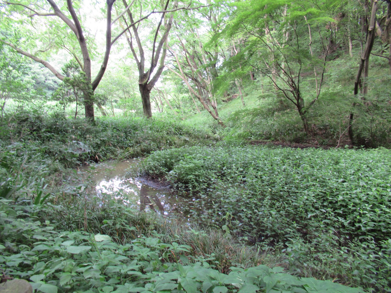 |
| It’s the area, beginning of
beyond Area 6. The water gathers here and then pours into the ponds in front of the North Entrance. |
 |
| The road is very wide and well-maintained anyway. |
 |
| Shade loving maples are thriving along the water stream. |
 |
| This is the steps leading to small
West Entrance. Mind you, this is the longest and steepest slope of the Park, more than 100 steps ahead. Popular training course for trail runners, inevitably. |
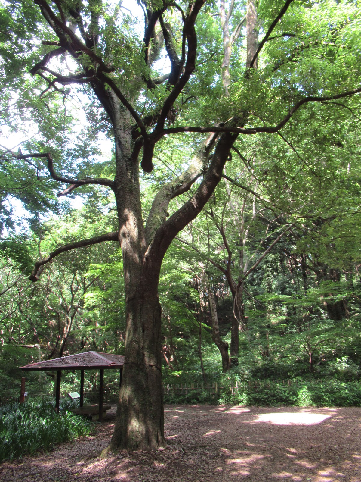 |
| A mighty bamboo-leaf oak |
 |
| It’s beautiful in December … |
But the main reason why Shikinomori Park is popular comes from the area surrounding the pond in front of the North Entrance. This is a part of the Park well-manicured. Area 6 is a shallow pond for irises that are full-bloom from late May to early June. The valley opposite to Jabu-jabu Ike beyond playground ridge is a substantial valley of reeds where fireflies make their home. From there, they come out to the space surrounding the front pond, dancing in early June. People visit here en masse, literally, even from Chiba or Saitama Prefectures beyond Tokyo. Unfortunately, this year the management of the Park cancelled night-time festival for fireflies due to the threat of the pandemic. I personally think it is a good thing. For several years, I’ve heard murmurs like “Well, Shikinomori’s firefly festival became too grande. The habitat of fireflies is certainly disturbed, and the number of bugs we can count during the season is dwindling for sure. We have to do something.” Huh, COVID-19 has done a favor easily, perhaps, for fireflies. Let’s always look on the bright side of life! If next year we don’t have problem like 2020, fireflies will present us their dancing show again in June. The area is surely well-maintained so that you can enjoy their performance even in wheelchairs. Keep crossing fingers …
 |
| It’s a large pond. |

 |
| The wetland has strong current which keeps the water clean, suitable for fireflies. |
 |
| Irises were ending in the
middle of June. Yet, they were beautiful … |
 |
| I’ve met an Arctic Warbler this
June in Shikinomori Park. Will it stay here, or move to higher mountains? |
If you find environmental issues in Kanagawa Prefecture, please make a contact with Kanagawa Natural Environment Conservation Center 神奈川県自然環境保全センター
657 Nanasawa, Atsugi City, 243-0121
〒243-0121 厚木市七沢657
Phone: 046-248-0323
You can send an enquiry to them by clicking the bottom line of their homepage at http://www.pref.kanagawa.jp/div/1644/