
Kanagawa Prefecture has 6 lakes. They are, Sagami 相模湖, Tsukui 津久井湖, Miyagase 宮ケ瀬湖, Tanzawa 丹沢湖, Okusagami 奥相模湖, and Ashinoko 芦ノ湖. All but one are man-made, where dams hold back water of rivers. Lakes of Sagami (my post on December 15 and 22, 2017) and Tsukui (my post on October 20, 2017) are of Sagami River 相模川. Lake Tanzawa (my post on January 5, 2018 and April 5, 2019) is of Sakawa River 酒匂川. Lake Okusagami is of Doshi River 道志川 (my post on January 19, 2018). Lake Miyagase (my post on May 3, 2019) is made of waters from Sagami and Doshi Rivers. Lake Ashinoko is different. It’s the largest lake in Kanagawa Prefecture, and a naturally-made crater lake. Until some 3100 years ago, at the place where now we have Lake Ashinoko there was a beautiful stratovolcano called Mt. Kamiyama 神山. The old Hayakawa River 早川 ran in its caldera. The volcano erupted violently with phreatic explosions and pyroclastic flows. The mountain experienced sector collapses, and the debris dammed Hayakawa River. Lake Ashinoko was born. Former Kamiyama became Mt. Hakone 箱根山 aka Kamiyama (ASL 1437m), and the eruption still continues as of June 2022 in Owakudani Valley 大涌谷. This week is the first of several posts telling you my adventure around Lake Ashinoko.

4 man-made lakes serve as water reservoirs for the entire prefecture. Lake Ashinoko has a more complicated history in this regard. I’m going to explain it eventually in a later post. Today is for an annual event organized by Hakone Town to walk around Lake Ashinoko. In 2023, it was held on May 21 as the 39th occasion. During COVID years, they were cancelled, but it remains popular. Pre-Covid times tickets were allocated by lottery. If you’re interested in it, please check here next March to April and book your place. Of course, you can try the course all by yourself. The beauty of the arrangement is, the municipality prepares direct bus services between Odawara Station 小田原駅 and Lake Ashinoko at a reasonable price = more or less the same as the commuter service sans intermediate stops or detours of local bus. Walk-around the Lake is for more than a half-marathon of 21km. Quick and comfortable transportation before and after the event is nice, I tell you. Entire course has nice directions provided by the Hokone Town for the day, and several Red Cross personnel walk with us. The entire event is basically safe. 😉
 |
| The
special bus service departs from the north exit of Odawara Station. |
 |
| Townhall
people stand at the point to lead the participant of the event. And the rescue squad goes with us. |
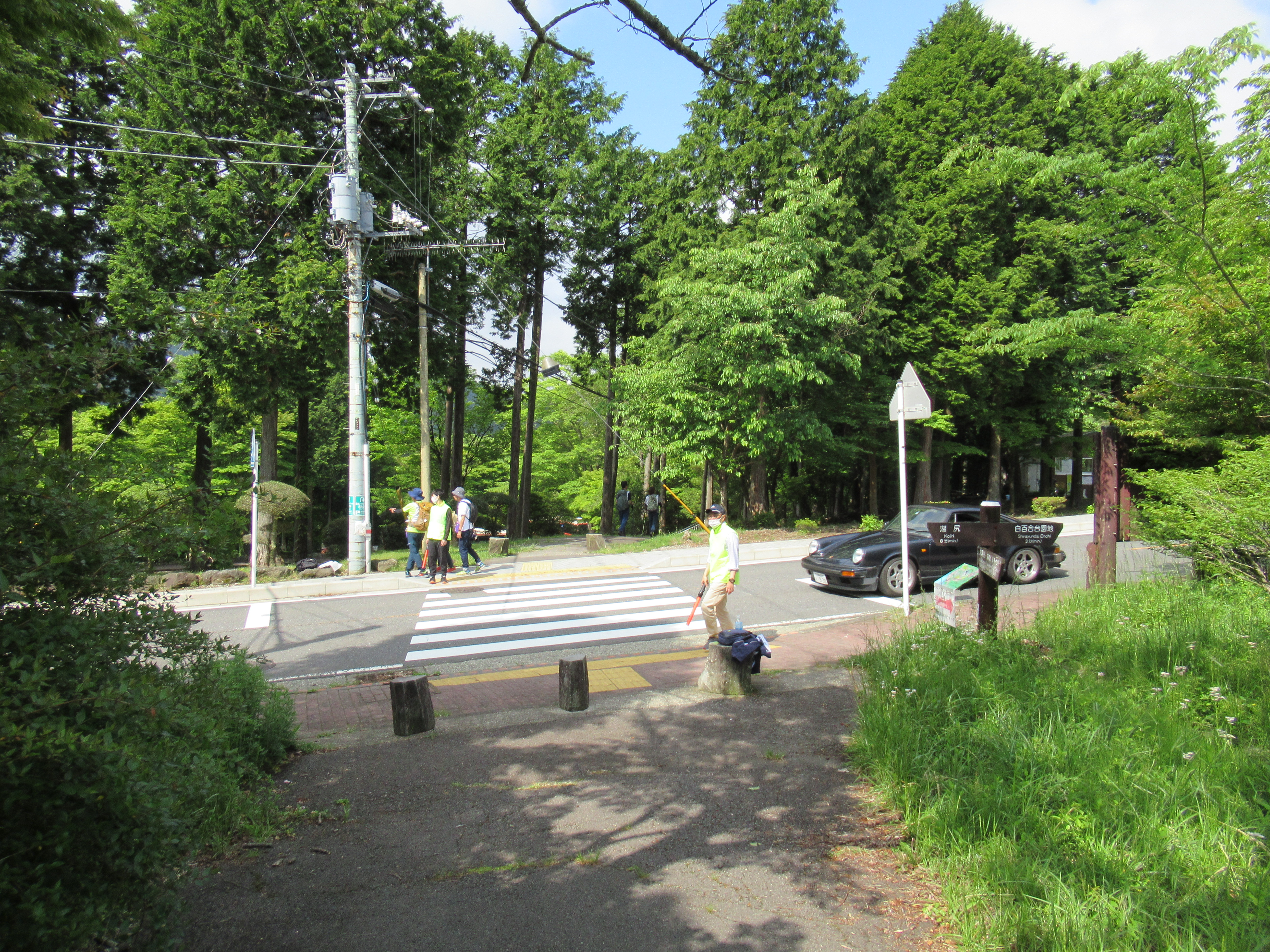
We started from Seisa Lake Arena Hakone 星槎レイクアリーナ箱根 that is a sport facility of Hakone Town. From there, the route for the event descend straight to Prefectural Route 75 that goes along the east shore of Lake Ashinoko (more to it next week). We cross Route 75, and turn right to enter Ashinoko Camp Mura Lakeside Villa 芦ノ湖キャンプ村 レイクサイドヴィラ. When we exit from a nice path in the Lakeside Villa, on our left, there is the Kojiri Watergate 湖尻水門 that “in theory” adjusts water supply from the Lake to Hayakawa River. I’ll return the point in a later post. The lakeshore near the Watergate is a small park with benches. From there, a graveled road departs from the paved motorway. Oh, FYI, that motorway enters the toll-road Ashinoko Skyline 芦ノ湖スカイライン. No pedestrians allowed. (There is a hiking road that runs more or less in parallel to the toll road.) Actually, unlike the east shore of Lake Ashinoko, the westside is almost entirely state-owned forest, really the space of “National Park” for nature conservation.
 |
| Starting point of Seisa Arena |
 |
| From there we go down straight to … |
 |
| Route 75. And straight way continues beyond … |
 |
| entering
Camp Mura. |
 |
| A beautiful giant dogwood ( Cornus controversa var. controversa) along our way. |
 |
| A small park next to Kojiri Watergate |
 |
| From there a graveled road begins. |
At the beginning of the route from Kojiri Watergate, the graveled road is wide enough for a small car to enter. There is a reason for this facility. In less than half an hour walk from the Watergate, there is another smaller watergate called Fukara Watergate 深良水門 where water gushes out from the Lake. This is the place showing the complicated history of Lake Ashinoko. I’ll return it, so give me time. The wide road is for maintenance crew to come here. After the Fukara Watergate, the road around the Westshore becomes truly a hiking road, sometimes clinging to a steep collapsing slope of crater lake. I’ve been there with my jogging shoes just by reading the contour lines of the map. The course is really flat, yeah. But the 2-D map does not tell the falling-down muddy slope where the hiking course runs, or piles of unstable and mossed volcanic rocks crossing the route. The rocks are for small dry streams when the weather is fine, but when it rains, they would surely become paths for raging waterfalls to the lake. If you go there, please do not make the same mistake as mine. Be prepared!
 |
| Along
the graveled road, we meet with the afforested conifers. |
 |
| At the
point of Fukara Watergate, there begins a hiking route leading to the trekking course along Ashinoko Skyline. Oh, you can start this ridgeway walk not coming here but enter straight from Kojiri Watergate point. To tell you the truth, entering the ridgeway from Kojiri Watergate requires steep climbing, but going up from Fukara Watergate is easier. |
 |
| On our
left is Lake Ashinoko. Maps say there are beaches here and there, but I could not find “beach” except one called Shirahama (White Beach) at the very end of Westshore. |
 |
| Eventually,
the route becomes a standard hiking road. |
 |
| But the signs are shown. |
 |
| It’s slippery moss-eaten way. |
 |
| This is the angle a crater can give. |
 |
| The road is cut into pieces by dry streams like this. |
 |
| This is another dry stream jumping into the Lake. |
 |
| Sometimes, there is a help of wooden bridge. |
 |
| Please
don’t step off the route, especially to the left, aka to the Lake. |

That’s said, the Westshore walking path of Lake Ashinoko is really an impressive course in a natural forest spreading over the sharp slope of crater. In the middle of May, blood orange flowers of wild torch azalea (Rhododendron kaempferi) adorned the rim of the lake in a way they never show in a neatly pruned garden. Although there is a debate if Weigela coraeensis in Hakone is different from these in the other parts of Japan, those on the Westshore of the Lake are pure white, which is a sign they really are Hakone Weigela coraeensis. (FYI, standard Weigela coraeensis has variegated colors of flowers from red to white in one tree, with more elongated leaves of larger serration.) Clematis japonica casually dangled lots of purple-red pretty flowers along the slippery trekking course. Meanwhile, beautiful colonies of moss Pyrrhobryum dozyanum welcomed our foot here and there. I was impressed. The course was full of the natural beauty of Hakone National Park.
 |
| Wild torch azalea |
 |
| Hakone Weigela coraeensis |
 |
| Clematis japonica |
 |
| Pyrrhobryum dozyanum |
 |
| … and
I found lots of Monk’s food in this course. Be aware that! |
After passing the memorial of the deceased by the 1930 inland earthquake for Hakone and Izu, the course returns to graveled road accessible for cars. On our right, there appear afforested conifers with signs telling us management of the forest is done by the national government. I could find several food marks by deer in the vegetation along such road at the beginning and the end of Westshore hiking course. Hmmmm … animals do not like precipitous crater slopes either when they can choose … We soon met with the entrance for Hakone Yasuragi-no-mori Forest 箱根やすらぎの森, a natural park managed by Hakone Town. From here the road around Lake Ashinoko to return to Seisa Lake Arena is paved 10km. I’ll tell you about my adventure there next week. It’s a main street of “International tourism of Hakone,” mate. 😉
 |
| The earthquake memorial |
 |
| Spathe
of this Cobra lily (Arisaema) is eaten. Oh my … it contains lots of aldehyde, doesn’t it? Was the eater alright? |
 |
| Shirahama Beach |
 |
| The road returns wide. |
 |
| The entrance to Yasuragi-no-mori Forest |
The event is organized by Hakone Townhall, but the condition of the Hakone National Park is in the end watched by Hakone Visitor Center of the Ministry of Environment. Actually, the center is next to Seisa Lake Arena. The contact info for the Visitor Center is
Hakone Visitor Center of the Ministry of Environment 環境省箱根ビジターセンター
164 Motohakone, Hakonemachi, Ashigarashimo-gun, Kanagawa, 250-0522
〒250-0522 神奈川県足柄下郡箱根町元箱根164
TEL:0460-84-9981
FAX:0460-84-5721
http://hakonevc.sunnyday.jp/english-info/
+ Hakone is a place with lots of rain and natural incidents. If you try the Westshore of Lake Ashinoko by yourself, you’d better check first the HP of Visitor Center if the course is accessible. Landslides, lake-flood, fallen big trees, … you name it. The hiking road is often closed due to such incidents. Good luck.

No comments:
Post a Comment