
East
African Rift Valley, Baikal Rift Zone, Rhine Valley, Death Valley … On this
planet there are several gigantic grabens that the movements of Earth’s crust
are creating. It may not be so-dramatic as its siblings, but Japan also has
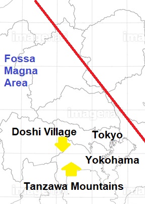
such physiographical feature. Kanagawa Prefecture happens to situate in the
middle of it. The area is called Fossa Magna, named by German scholar, Heinrich Edmund Maumann, in the late 19th
century. He noticed in this small archipelago, there were two strikingly
different strata. One is estimated to be created around 550 to 65 million years
ago. Another, aka Fossa Magna, is of
25 million or younger years ago. The thickness of Fossa Magna is about 6km in
planes, and 9km in mountains. Interestingly, younger stratum is sandwiched by
older strata, and it’s bended that presents a characteristic bow-shape of
Honshu Island 本州.
 |
| The northern border of this map is still hotly debated among scholars. |
The scholars consider the area was first instigated by the crush of Eurasian and
North American Plates. Such moving lithosphere produced a large fissure from
north to south of the ancient Japanese archipelago that was then straighter and
nearer to the Eurasian Continent. The crack formed a large U-shaped valley along
the split and simultaneously pushed the islands to the east. The space between
the moving island and the continent eventually became the Sea of Japan. Next, the
Philippines Plate joined the melee from the south by bringing the seabed up and
annexed at least 2 islands from the Pacific Ocean to the former seabed area.
The islands are now Izu Peninsula 伊豆半島 and Miura Peninsula 三浦半島. All the collisions bent the Honshu Island. A
gigantic pile-up of plate tectonics stimulated the magma oozing out from the
core of the planet and gave the Honshu a beautiful chorus line of erupting
volcanos in the middle. Mt. Fuji 富士山 and Mt. Hakone 箱根山 are a part of the troop. Volcanic ashes piled
up over the bowed graben, and the current day Fossa Magna was created. That’s that … With this bookish knowledge,
I simply thought the soil of Fossa Magna
area is more or less the same. That was laughably wrong. I noticed it in Doshi Village 道志村.
 |
| Doshi River running in Fossa Magna |
It would
be better to check the location of Doshi and Tanzawa Mountains. Doshi Village is
spreading over the northern slope of the Tanzawa Mountains 丹沢, down from the rim at approx. ASL 600 – 1580m. This ridgeway is
also a border between Yamanashi 山梨 and Kanagawa Prefectures 神奈川. The scree-covered area I talked last week was
in the southern slope of Tanzawa, on the south slope of Mt. Nabewari (ASL
1272m) 鍋割山 to be exact. From there, we can enter the main
peaks of Tanzawa, starting from Mt. Tonodake (ASL 1491m) 塔ノ岳, then
Mt. Tanzawasan (ASL 1567m) 丹沢山, Mt. Hirugatake (ASL 1673m) 蛭が岳, Mt. Hinokiboramaru (ASL 1601) 檜洞丸, Inugoeji Pass (ASL 1168m) 犬越路, and Mt. Omuroyama (ASL 1587m) 大室山 that is on the prefectural border. i.e.
Between the last week’s forest and the forest of Doshi Village, there lies a
block of mountains with lots of ridges and gorges. The characteristics of
Tanzawa Mountains is, although they are not so high, they are very steep, and
consequently they have deep valleys that can provide good water for us in
Kanagawa Prefecture. I just recalled the reason for their sheerness is due to
the collision of the Philippines Plate from the south with the North American
and the Eurasian Plates. They are contesting each other, and pushing up the
seabed of the Pacific Ocean even now. So the soil of south-side of Tanzawa
Mountains is fragile mixture of marine sediments and volcanic rocks spewed from
Mt. Hakone and Mt. Fuji. The tip of Philippines Plate is somewhere near Mt.
Hakone, around Mt. Yagura 矢倉岳 (ASL 870m) we visited August
last year. Lots of gravels we find last week would be a kind of features of the
push by the Philippines Plate. But this becomes less evident after we cross the
land mass of Tanzawa and go north of Doshi River 道志川, that’s
what I’ve found.
Average annual precipitation in Doshi Village is
1677mm (1982-2012), while that’s for Yadoriki Community is 1545mm. Yeah, Doshi
definitely has more rain than in the slope of Nabewari. So it may explain the
difference in the forests. As long as historical aspects of the treatment of
the forest, Tanzawa and Doshi are basically the same. Both were Goryo-rin 御領林, properties of the central government and protected
by the Shogunate Government 江戸幕府 since the 17th
century, and then from the middle of the 19th century by the Emperor.
But during the first half of the 20th century, Tanzawa experienced
substantial deforestation for military expansion of Japanese Imperialist
government. In contrast, Doshi Village kept their trees as water source forests
for the international port of Yokohama. That may have made the disparity between
the trees, but if the time of afforestation was more or less the same for the
both forests, as the size of the trees suggested, the forests in Doshi and
Yadorki would have toed the mark equally. The remoteness from the population
center? It takes roughly 3 hours from Shinjuku 新宿 to a
forest in Doshi Village. It’s about 2 hours to a slope of Nabewari. In terms of
the availability of foresters, the forests in Tanzawa could receive human cares
more easily. But …
 |
| Mountains
of Doshi Village, far from the crowds in Shinjuku … |
With a fresh memory of the scree-covered floor
for a forest in Tanzawa, this September I entered in a forest spreading over the
south slope of Mt. Nabatakeura (ASL 1283m) 菜畑山, Doshi
Village. Even for my inadequately trained eyes, the cedars and cypresses in the
afforested slope of the Village were … beautiful. They stood straight, and the
cut ends of logs were almost always so clean. Probably their age is the same as
for the forest in the slopes of Nabewari … But the number of gnarling trees was
definitely larger in Mt. Nabewari. The reason of the difference I could think
of was, the soil. I was surprised to step on that so-soft soil, although the
steepness of the mountain was more or less the same as in the south slope of
Mt. Nabewari. Unlike the ridgeway of Mt. Nabewari, not much scree was there. The
mixture of cypresses and cedars let the soil abundantly covered by leaves and
branches of coniferous trees. It must be preventing the soil from erosion. But
the same thing could have happened in Tanzawa if they would have had the same
kind of soil as Doshi … Come to think of it, Doshi Village does not have deer
problem as in Tanzawa. It must have made the biodiversity of the forest much
richer in Doshi than in Tanzawa. Hmmmmmmmmmm …
 |
| An angle-wise, this photo of a forest in Doshi Village is the same as |
 |
| this
photo taken on the south slope of Mt. Nabewari. Could you figure out the difference in forest floor here, compared with the above photo? |
 |
| Soft forest floor in Doshi Water Source Forest |
 |
| A
close shot. The place is covered with the leaves and branches of cedars and cypresses. |
 |
| And
lots of small-sized broad leaved shade trees, including Lindera umbellata. Doshi forests do not have deer problem so that the forest floor can keep many plants that might have been eaten up by the animal if their population exploded as in Tanzawa. |
 |
| This is the forest floor of Mt. Nabewari. The place is dominated by Boenninghausenia albiflora var. japonica which deer hate to eat. |
In terms of higher category of strata, Doshi
and Tanzawa belong to the same Fossa
Magna area. But probably Tanzawa’s feature would be more unique due to the Philippines
Plate and the deer. Predictably, the southern part of Fossa Magna around Tanzawa has a unique ecology with a group of
flora called Fossa Magna elements.
They are typically found in Tanzawa, Hakone, Izu Peninsula, the southern slope
of Mt. Fuji, and Izu Islands 伊豆諸島. These plants are so tough that
can survive and thrive in rocky and steep soil of Tanzawa Mountains ... I don’t
know Doshi Village is the place for the Fossa
Magna elements … but at least Tricyrtis
affinis (not Fossa magna element) are definitely more vigorous in Doshi
than in Yadoriki. There would be more to learn about Fossa Magna. That’s for sure ...
 |
| Cirsium
microspicatum Nakai, a thistle endemic in Fossa Magna of Japan. |
 |
| Hosta longipes var. longipes, a hosta and ditto! |
 |
| Tricyrtis affinis in Doshi Village. They are simply abundant even along a commuter road to schools and clinic. |
 |
| The
highest peak behind the Doshi elementary and junior-high is Mt. Nabatakeura. |
Doshi
Village Office 道志村役場
6181-1
Doshi Village, Minamitsuru-gun, Yamanashi, 402-0209
〒402-0209
山梨県南都留郡道志村6181-1
Phone: 0554-52-2111
FAX: 0554-52-2572
http://www.vill.doshi.lg.jp/

No comments:
Post a Comment