In yesteryears, Sagamihara plateau was a place difficult to have thriving agricultural communities, due to the scarcity of water. But the plateau is sandwiched between Sagami 相模川 and Sakai 境川 Rivers. There were old villages along the rivers for centuries. Villagers there could use water from the river. They could cultivate rice. In the 21st century, the difference for the access of water is not much between the two areas. But the forests are different. Today, I tell you my adventure in a forest near Sagami River of Sagamihara City. It’s Dohogawa Park 道保川公園 of 7.7ha.
 |
| A map of Dohogawa Park, shown on site |
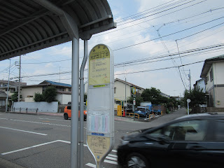
To know how the two areas of Sagamihara are different, I recommend you using commuter bus services from JR Sagamihara Station 相模原駅 or Odakyu Sagami-ohno Station 相模大野駅. Otherwise, please walk from JR Kamimizo Station 上溝駅 for 20 minutes. There are lots of bus services from Sagamihara Station South Exit by Kanachu-bus of Sou 相 - 21, 25, 7, 28, and 29 (; checking timetables is from here), or of Oo 大 - 25 from Sagami-ohno Station (North Exit; the timetable is from here). A bus-ride from Sagamihara Station is about 10 minutes, whereas from Sagami-ono is 35 minutes. Whichever you take, please get off the bus at Nishi-hikarigaoka 3-chome Stop 西光が丘三丁目. You’ll see Family Mart Convenience Store near the stop. From the corner of the Fami-ma, there is a residential road going straight to the west. Please dive in, and about 5 minutes from Fami-ma, there is Yokodai 陽光台 Community Centre on your left. Keep on going, and you reach to an open space named “Jo-dan Hiroba 上段広場” of Dohogawa Park. It means “upper-part open space.” Very apt. So far, we walked Sagamihara Plateau, flat with lots of houses and commercial premises but very few greeneries. The open space we’ve just arrived is at the edge of the plateau, with trees!
 |
| Bus terminal from the South Exit of Sagamihara Station |
 |
| The
stop for bus services from Sagami-ohno Station, going near Dohogawa Park |
 |
| The
bus stop Nishi-hikarigaoka 3-chome you should get off if you come from Sagamihara Station. |
 |
| Family Mart with an ample parking space |
 |
| Now, to the Park go straight. |
 |
| Yokodai Community Centre |
 |
| Keep on going. Could you see trees over there? |
 |
| We’ve arrived Jo-dan Hiroba of Dohogawa Park. |
“Dohogawa” means “Doho River.” It’s a tributary of Sagami River joining the mainstream at about 5km down from the Dohogawa Park. The Park is spreading along the water source of Dohogawa. i.e. It‘s a park of natural water, very different from the plateau forests like Komorebi-no-mori Forest こもれびの森 (; my post for July 14 and 21, 2024), or Sagamihara Park 県立相模原公園 (; my post for January 25, 2019). From the open space we arrived, on our right a steep slope goes down directly to the riverside of Dohogawa. Let‘s go down to the river. It is steep, I tell you. The slope, or the cliff, is covered by both broad leaved and coniferous trees. I was impressed by the geology Sagami River created. It is an experience to feel the fluvial terrace.
 |
| At the
beginning of the steps going down, there is a gate and these notice boards. |
 |
| Beginning of the steps |
 |
| We‘ve gone down this much! |
The forest of Dohogawa Park is acted as a water source forest for Dohogawa River. The scenery is definitely different from the residential area we went through from the bus stop. Plateau part had rows of homes, with not much garden or greenery. In yesteryears the area was probably grass land or forest consisted of drying-resistant trees. But if we come near the river, broadleaved trees that love moisture, such as maple trees, appear. It is said that previous landlords of the Dohogawa Park engaged in Wasabi cultivation which requires lots of water. With the greenery at the plateau table and the forest spreading over the slope retaining rainwater, once the river had enough H2O for the business. Alas, the residential development dramatically reduced the expansion of water source greenery, and now the river flow is not much, unsuitable for Wasabi. The municipal park was opened in 1990. For opening, the civil engineers were worried if the park could maintain the sufficient amount of water for the river. So, before the inauguration, the City of Sagamihara dug 6 wells. The water from the wells is released to Dohogawa River and keeps the water level. Although the river looks running naturally, it has a huge boost by human hands. Next week, I tell you my adventure more in Dohogawa Park. Please stay tuned! 😊 Oh, by the way, Dohogawa Park has parking spaces along the river. Map of the Park and the parking is here.
 |
| Parking space for Dohogawa Park |
If you find environmental issues in Sagamihara’s City Parks, please make a contact with
Management Office of Dohogawa Park
道保川公園管理事務所
1359 Kamimizo, Chuo-ku, City of Sagamihara 252-0243
〒252-0243 神奈川県相模原市中央区上溝1359
Phone & FAX: 042-776-6484
You can email an enquiry to info-dohogawa-slcg@yokohamaryokuchi.com


No comments:
Post a Comment