Showing posts with label Cherry Blossoms. Show all posts

Sunday, April 5, 2026

Cherry Blossoms along the Shore: drought in Kanagawa Prefecture, spring 2026


Cherry blossoms! On April 1, Yokohama Local Meteorological Observatory announced its indicator cherry tree reached full blossom. Since then, we have a couple of days for spring storm, but at least around my neighborhood they keep their best. Hurrah! They will be so beautiful even when they are scattering. I hope a couple of more days left for us to steep in their ephemeral splendor … That’s said, something strange is happening. For one thing, the Meteorological Agency announced their weather forecast for this week: it’ll be warm days including several “hot days” with the temperature at the level of June. Their next 3 months’ forecast also says “The average temperature in Kanto Region will be high, and rainy monsoon season could start earlier than usual.” Well, do you remember my “prediction?” Soon after cherry blossoms, summer will come.


The early coming of monsoon season should be welcome. Actually, this winter was so dry in the megalopolis Tokyo area. Kanagawa Prefecture was not an exception, nor Yokohama. Our reservoir lakes for water supply remain in critical condition. As of April 4th, the entire water storage rate for Kanagawa’s main water system, i.e. Sagami and Sakawa River Systems, is 39%. It’s after more than 2 weeks of on-and-off rainy days. The worst is Tsukui Lake with Shiroyama Dam (; my post on Oct 20, 2017). The lakeside Prefectural Park, Tsukui Shiroyama Park, is famous for its cherry blossoms. But … look.


When a reservoir is like this, so is upstream area. This is the recent Yadoriki Stream. The comparison tells obvious: water level is low.

At the end of March 2026.
Right bank is dry enough to become grassland.

Yadoriki Stream in standard March

Yadoriki Water Source Forest is for Sakawa River system whose reservoir lake, Lake Tanzawa, shows 46% of water storage rate, or 51% of average year on April 4th. Tsukui Lake, a reservoir lake for Sagami River, shows 16% of storage rate or 21% of average year. i.e. Yadoriki Stream has more water than the other water source forests in Kanagawa. It’s scary. Kanagawa Prefecture and Tokyo Metropolitan Government have a water sharing agreement, and in normal times the Prefecture diversifies 220 million m3 water per day to Tokyo from Sagami River. Since last month, Sagami River could not continue this, and the supply to Tokyo was reduced to 110 million, i.e. halved, per day. The rainfall from mid-March has not yet let reservoirs recuperate from the drought.

The water level immediately after
the water gate of Shiroyama Dam.
Could you see the water level is so low?

Water source area is like this, and so is the downstream, i.e. Yokohama. We Niiharu Lovers worry if this spring frogs have enough water for their eggs. Next to Yatoda rice paddies in Asahi-Yato of Niiharu, there are two small ponds. They normally hold water for gelatinous frog eggs. If it’s tube-like, they are eggs for toads. If they are foamier, they are for Japanese brown frogs. This year, none. Reason? Both of these bonds are dried up. Frogs need water from February to March for their tadpoles. If there is no water, they do not lay eggs to begin with. “It’s sad.” “Yes. Oh, I’ve found some eggs in ponds next to Ikebuchi Open Space.” “Me too! They are brown frogs, aren’t they.” “But you see? The other day, I’ve been there in dusk and heard an owl hooted in a tree over the pond.” “What!? They are eating eggs and tadpoles.” “Oh yes.” Survival of the fittest. This is a harsh year for frogs in Yokohama.

Dried up
From rice paddies another stream goes to
the (artificial) pond next to Niiharu Community Centre
 in Satoyama Park.
It also has poor level of water.
As the pond in the park is man-made,
it keeps water somehow. But …

Tadpoles in Ikebuchi pond.

If monsoon comes earlier than usual with enough rain, it could give some respite for our water system. Yet, volunteers who nurture Yatoda rice paddies in Niiharu are seriously worrying the prospect of this year’s rice harvest. I guess it’s not a problem only for amateur farmers in our community. With soring energy cost (i.e. it’s more costly pumping from agricultural waterway), low or none water level is worse for agricultural production by pros. Last year’s harsh summer yielded poor crop of potato and onions in Hokkaido, and the cost of these is shooting up now in supermarkets in Yokohama. Let us keep crossing our fingers as the situation improves and we have sufficient water supply this summer. God willing …

Small flow for
Asahi-yato rice paddies this March.
Correction: No flow.

The flows from Niiharu Forest gathers in Umeda River,
then to Tsurumi River.
Inevitably, the water level for Umeda River is low now.
 It would be good news for Egretta garzetta
to procure meals in Umeda River. But …

If you find environmental issues in Kanagawa Prefecture, please make contact with

Kanagawa Natural Environment Conservation Center 神奈川県自然環境保全センター
657 Nanasawa, Atsugi City, 243-0121
〒243-0121 厚木市七沢657
Phone: 046-248-0323

You can send an enquiry to them by clicking the bottom line of their homepage at http://www.pref.kanagawa.jp/div/1644/

Sunday, April 13, 2025

Goodbye Cherry Blossoms: Sakura this year around me


This year I did not intend to tell you about cherry blossoms. But … I could not resist. I have not been anywhere to admire particularly blossoms this year. Nevertheless, these are photos taken in familiar places for me.

Cerasus jamasakura in Niiharu Citizen Forest 新治市民の森. Late Mr. Nakamaru, the first chair for the Lovers Association of Niiharu Citizen Forest 新治市民の森愛護会, once said cherry blossoms must be seen from afar. Indeed.


This is also from Niiharu, in Ikebuchi Open Space. Personally, I think the beginning of April is the time when Niiharu Citizen Forest is the most beautiful ...


And we can find more cherry blossoms inside Niiharu Citizen Forest. This scenery is from the open space next to the Workshop.


This is the promenade for Satoyama Garden, Yokohama. These old Cerasus Jamasakura go strong.


Cherry blossoms, Someiyoshino, Street in front of the Forest Lab. Next to the venue for art show, there are two elderly care facilities whose buildings are surrounded by Someiyoshino trees … Hmmmm. Grandmas and Grandpas spend their final days with cherry blossoms. I think it’s not bad.


In Yadoriki Water Source Forest, we can spot wild cherry blossoms here and there on the slopes. I have not identified the one in this photo, but chances are, it is Fuji Cherry found especially around Mt. Fuji. Botanically, they are categorized as a species of Fossa Magna Element = endemic species for Fuji-Hakone-Izu National Park, and Tanzawa-Oyama Quasi-National Park. They are found only in deep mountains of the area. The petals of the beau are smaller than Someiyoshino, and the colors are paler. More ephemeral ...


Yadoriki Water Source Forest also has a series of cherry trees near the entrance. They are Someiyoshino planted intentionally 50 or so years ago when the place was a camping facility. Of course, now such an act is not welcomed for the Quasi-national park. Anyway, they are beautiful, aren’t they?

Just like the global stock market, this spring weather in our neighborhoods is jumping around. One day, it’s freezing cold and the next morning is hot requiring half sleeves. I guess plants are confused and decided to flower at once in Yokohama and Kanagawa, as for spring of the places in more northern area.

Chinese fringe flower in a garden next to the Forest Lab.
They are supposed to be full bloom after the cherries.
This year, on one go!

Cherry silver berry is also in full-bloom along Umeda River
 near Niiharu Citizen Forest.
They are also after cherry blossoms.

Lonicera gracilipes var. glabra open their flowers
 finally in April for Niiharu!
 They are supposed to be so before cherry blossoms.

Lots of fertile stems of Field Horsetail (; my post for April 13, 2018).
Er … you’re late!
You should be like that before cherry blossoms!

Violet orychophragmus in Niiharu Citizen Forest.
They are designated as “Invasive Species” to Japan.
 In any case, beautiful …

Mmmmmmmmmmmmm! It’s spring. Though, cold rain this weekend will disperse cherry blossoms, and summer is coming. Goodbye, this year’s cherries. Well, next week, I’ll return photos I’ve taken during this winter. The brown scenery again. Reason? I tell you my recent adventure in Koajiro Forest 小網代の森. To explain it, it’s better using photos taken during winter. Please stay tuned!

Stachyurus praecox in Yadoriki Water Source Forest

If you find environmental issues in Kanagawa Prefecture, please make a contact with Kanagawa Natural Environment Conservation Center 神奈川県自然環境保全センター

657 Nanasawa, Atsugi City, 243-0121
〒243-0121 厚木市七沢657

Phone: 046-248-0323

You can send an enquiry to them by clicking the bottom line of their homepage at http://www.pref.kanagawa.jp/div/1644/

Sunday, February 23, 2025

Pounding: making mochi cake at the top of Mt. Kobotoke-Shiroyama 小仏城山


Rice cake, mochi in Japanese, is popular in Japanese cuisine. It’s made of steamed sticky rice pounded enough to be the rice gummy. It takes a certain effort to make it. In yesteryears, it was a regular menu for village festivals and served each community member as a token of celebration. The time when Japanese consume mochi most must be for New Year Celebration. It can carry symbolism of the tradition, like Hot Cross Bun for England. Having said this, now in the 21st century we can purchase it all year round from supermarkets, neatly wrapped and ready to be popped in a toaster. Traditional meaning aside, making mochi is a fun group activity. So, please try Aotengu mountain café 青天狗 at the top of Mt. Kobotoke-Shiroyama 小仏城山. This week I tell you my adventure of mochi-making there.

That day, Mt. Fuji was beautiful ...

First, where is Mt. Kobotoke-Shiroyama? It’s the next peak from uber-popular Mt. Takao 高尾山. How to go Mt. Takao must be explained a lot in the travel guides for Japan or Tokyo. I omitted the itinerary today. Between Mt. Takao and Mt. Kobotoke-Shiroyama, I posted travelogue several times in this series, including the route for enjoying the “most beautiful cherry blossoms in Tokyo (; my posts for February 25, March 4, March 11, 2022). Please check these if you like. In any case, although there are several branch trekking ways between Mt. Takao and Mt. Kobotoke-Shiroyama, it‘s a simple one way direction. The majority of branch roads meet soon several times, or join at the top of the mountain at the end of the day. + It‘s uber popular hiking course. You simply join the crowd, and Mt. Kobotoke-Shiroyama is just there. As long as you wear good shoes + hiking gear and carry enough water, don‘t worry ... er, it‘s becoming problem these days accidents are happening too often especially among overseas visitors who are not at all prepared for hiking. Although it‘s not Mt. Everest, the mountain is a mountain, and we must get ready for walking such environment even if it is for Mt. Takao. There are of course the other routes reaching to Mt. Kobotoke-Shiroyama skipping Mt. Takao. It’s a bit complicated operation, including finding bus stops or entrance to hiking course, etc. So, I skip these today: main topic is POUNDING MOCHI!

Along the route,
there are many maps showing the routes around Mt.Takao.
 Follow these directions together with your fellow hikers.

Actually, the most important thing for having rice-cake fun at Kobotoke-Shiroyama is Making Reservation. From their HP of this, there is a reservation link. The café Aotengu 青天狗 moved from the neighboring peak of Mt. Kagenobu 景信山 last March, and with this they transfered mochi-making service to the top of Mt. Kobotoke-Shiroyama. When you make reservation, please tell Mr. Aoki, the owner of the café, the date and expected arriving time of your party. In order to make mochi it is needed one overnight soaking of rice before steaming them, and so RSVP. Also, you need to confirm your mochi-making by 15:00 of the day before of your fun. Oh, I have to add this: you cannot make mochi alone. At least two people are needed, and Aotengu does not offer variety of portion: 3kg of sticky rice only. We’ve been there 6 people, 5 males and me, ate mochi enough, and could prepare souvenir for 7 families. You see? Mochi-making is the thing of festivals!

Aotengu Café

Aotengu Café prepares the tool for mochi pounding (mochi-tsuki in Japanese), i.e. a set of pestle and mortar, and 3kg of steamed sticky rice, for around 9000 yen. As these days the price of rice in Japan is super volatile, please ask café how much it is now. The Aotengu also can lend us a portable stove, a deep pan, and a ladle, all of which are in separate charge. We brought by ourselves these tools + lots of H2O, hand sanitizer and plastic gloves for serving food. Mr. Aoki said OK for this. H2O is very important as there is no water source at the top of the mountain, you know. However, if you bring in alcohol drink by yourselves, Mr. Aoki will charge 1000 yen per person, as his café sells such beverages. Please be a nice customer for Aotengu. Aotengu Café also advertise special relish for enjoying mochi cake, i.e. minced Japanese leeks mixed with yuzu-taste miso paste. Or you can bring your own condiment and the other ingredients for your mochi dishes. It’s OK. By the way, eating mochi with butter and soy sauce is very popular these days. Tomato sauce or olive oil with salt also goes well with mochi. The menu with mochi could be infinite if you like. Mochi with cheese and chocolate sauce is also my favorite 😊.

Steamed 3kg of sticky rice,
situated neatly in a large mortar.
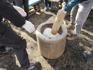
 Traditionally, Japanese mortar for mochi pounding is
 made of a large trunk of Japanese zelkova,
hollowed out for this usage.

When the rice is ready, we need to work with it quickly.
First, mash the rice with pestle.
Oh, you’d better wet the pestle before the start.
 Otherwise, the rice sticks to it,
and mochi pounding becomes messy.

Mashing …

until the rice becomes this level of gooeyness.

Then, turn over the now so-so gummy mass
of sticky rice upside down.

Finally we start pounding.
Don’t waste your time reaching to this stage.
Rice still must be very hot.
Several times of pounding,
then another person turns over the rice.
 Continue the routine.
 So we need at least two people for mochi making,
 in order to avoid cooling of rice in the process.

The key to pounding is
using gravity working on the heavy pestle.
You wind the pestle up, aim the rice, then,

swing down the pestle.
I tell you
hitting the rim of mortar is not a rare thing.
It requires a certain technique
for smooth pounding.

Almost there …
the rice cake still must be hot at this stage.

The other things we noticed we should have brought were

1. Corn starch and clean operation sheets like perchment paper for bakng. After pounding mochi-cake, we have to divide a mass of mochi into at least a loaf size or smaller. At the top of the mountain, there are only outdoor picnic benches which is not suitable for working with food on it. We managed with the things we brought this time, but reminded ourselves next year we’ll be more organized. 

2. More variety for condiments/relish to enjoy mochi. We brought only soy source and nori seaweed, which is a bit too simple for rice cake for roughly 20 people. I really regreted I have not brought cheese and chocolate sauce …

Done.
We forgot bringing corn starch and operation sheet
 … only chop sticks.
Hmmmmmmmmmmm.

Things worked out somehow.
We had it with soy sauce, nori seaweed,
and sweet soybean flour.
We also cooked soup with carrots,
Japanese leeks, chix, and mochi.
It was a cold day.
Hot mochi was delicious.

Anyway, it was really a fun. Also we must be in a hurry for mochi-tsuki as we have to finish our task when the steamed rice is hot enough to be glutinous. Yeah, we must preserve our energy for doing this after going up the mountain. But empty stomach does not have to wait for long ... er I’m not sure if it is a suitable activity for hot summer … but it is certainly very popular entertainment. Aotengu Café said by the end of this March all the reservation is taken as of today. The chance to enjoy mochi pounding at the cherry blossoms season maybe for next year? Please consider.

Megalopolis Tokyo over there …

If you find environmental issues in Kanagawa Prefecture, please make a contact with Kanagawa Natural Environment Conservation Center 神奈川県自然環境保全センター

657 Nanasawa, Atsugi City, 243-0121
〒243-0121 厚木市七沢657

Phone: 046-248-0323 

You can send an enquiry to them by clicking the bottom line of their homepage at http://www.pref.kanagawa.jp/div/1644/

Sunday, May 5, 2024

For your next year cherry blossoms’ party: Kinugasa-yama Park of Yokosuka City 衣笠山公園


Returning the topic of planting cherry trees around Mt. Ogusu 大楠山, we have to check Kinugasa-yama Park 衣笠山公園. Last week, we started our hike from JR Kinugasa Station 衣笠駅. The area of Kinugasa was once the home ground of Miura Clan 三浦一族, who were the biggies of Miura Peninsula. The height of their power was in the 13th century until then the head of the Clan, Miura Yasumura 三浦泰村, lost the political and military power to his rival, Hojo Tokiyori 北条時頼, in Kamakura Shogunate 鎌倉幕府 in 1247. Yasumura was #2 in the Shogunate hierarchy. Tokiyori was #1 … a familiar story, don’t you think? At the time of clan destruction, Miura family did not live in Kinugasa area but in Kamakura. Still, their political power in Kamakura Shogunate secured the special status of the peninsula. In the first place, the reason Miura Clan gained the position in the government was a fierce battle in 1180 and the death of Miura Yoshiaki 三浦義明, then the head of the Clan, in Kinugasa Castle 衣笠城 for the victory of Minamoto-no Yoritomo 源頼朝, the founder of Kamakura Shogunate. So, the meaning of Miura Peninsula around Kinugasa was not so trivial for Kamakura. They began planting cherry trees, and the tradition continues till this day of the 21st century. Do you remember the previous Emperor and Empress planted cherry tree near the Radar Tower (; my post two weeks before)? The ordinary citizens also contribute to the growing number of cherry trees in the area. There is a notice board near the imperial cherry by NPO Ikuoukai 育桜会, which is promoting the planting of cherry trees in Japan and beyond.

The notice board by Ikuokai near the Radar Tower.

The tradition of planting cherry trees around Mt. Ogusu also gave birth of one of the city parks of Yokosuka. It is Kinugasa-yama Park 衣笠山公園. The beginning of the Park was 1907 when the local governments (then, the city of Yokosuka and Kinugasa Village) built a memorial for war-dead during Russo-Japanese War and planted cherry trees on the Kinugasa-yama which was a continuation of old ruin of Kinugawa Castle. The place became the municipal park. Since then people keep planting the blossom trees, now counting more than 2000, and landscaping the slope of the park hill for citizens to stroll. In 1990, the place was designated one of the 100 best places for admiring cherry blossoms. Going there can be a part of Mt. Ogusu hiking. So, today I tell you the route to visit Kinugasa-yama Park. The easiest way to go there is by bus from Keikyu Yokosuka-Chuo Station and get off at Entrance to Kinugasa-yama Park stop 衣笠山公園入口 (; timetable is here and here). Though, going there on foot from JR Kinugasa Station can be an interesting adventure. I tell you how.

The costume wore by actors
who played Miura samurais in 2022 TV drama.
 They depicted the battle of Kinugasa Castle.
People in Kinugasa still love Miura family so much.
They displayed the outfit in one of the shopping windows
 next to the Kinugasa Station.

First, please check the map of Yokosuka City. JR Kinugasa Station has an exit of only one direction, to the north. And Kinugasa-yama Park is spreading south of the station. So, we have to find a way to go to the south of the station. We can take the long way around by following the car roads. Or, of course, there is a shortcut, only for pedestrians. From the station, please walk around the bus terminal and turn right at the corner of Mizuho Bank and Security. The street is of an old-fashioned shopping arcade with cars and buses running in the middle. Turn right again at the end of Mizuho premise for a narrow pedestrian road. It cranked to the left immediately, and in front of you is another shopping arcade running in parallel to the bus street. It keeps the atmosphere of the late 20th century Japan … Go a bit further down this shopping street to find a greengrocer on your right. Turn right here. You’ll enter a tunnel running beneath the JR Yokosuka Line. Voila! You’re in the south of Kinugasa Station. From the exit of the tunnel, we can find a residential road going up. In our sight, there is a church on your left and a hospital on your right over there at a small crossing. Please go there and take a way to the right along the hospital. You’ll find a condominium soon next to the hospital. Just pass the condo and the road is cranked to the right. Proceed the route and turn left at the third corner, go further, and turn left at the first. The end of this route is the beginning of a trekking road of Kinugasa-yama Park. All the routes so far are narrow residential commuter roads. Navigating up to here could be an adventure in itself!

The bus road running in front of Mizuho Premise.

Please turn right here.

Then left.
In front of you is this scenery of shopping arcade.

Turn right at the greengrocers.
Could you see a tunnel over there?

The other side of the tunnel,
i.e. the south of Kinugasa Station.

There is a map at the other end.
But, it does not help much, I tell you.

Turn right here at the hospital,
and walk along the hospital premises.

After turning the third corner.
I’m sure you are getting nervous …

Now, this is the adventure part!
Please dive in this VERY narrow road.
This is the final turn in the residential area.

The other side of the alley.
Could you see the greenery over there?
That’s our destination.

Going straight, and we come here.
Please feel relieved …

Phew! The entrance to the Park.

The road starting from here is, I would say, at the bottom of the Park. Yokosuka is a port city with nice terrain suitable for an aircraft carrier of the US Navy to make the place home. Inevitably, it is very hilly, and so for Kinugasa-yama park. It is spreading a steep slope of Kinugasa-yama whose previous name was Mt. Kurakake, ASL 134m. We first go along a relatively flat road with a pond on our right over the fence. It was once the water source for the people of the area. (Now everybody in Yokosuka use waters from Sagami 相模川 and Sakawa 酒匂川 Rivers.) At the end of the pond, there begins a well-paved route of the Park. On our right is a marsh that is a water source of the pond we passed. In June, the place is adorned with the lights of fireflies. Firefly place ends with a colorful playground with slides. The route of the park becomes seriously steeper around the playpark, but it is perfectly paved. Here and there, the City of Yokosuka provides a map of the Park that shows our present location. As a city park, it has several toilets which are shown in the map. Please don’t worry in this regard. The paved slopes are lined with well-taken-care of trees, not only cherries, but also oaks, paulownia, camelia, etc. As you go up, eventually we see the ridge of Kinugasa-yama. People planted cherry trees intensively along the ridge way. The route becomes the main attraction when the City has Cherry Blossoms Festival.

The beginning of the Park Road.

The pond appears in no time.

The marsh begins.

Such maps are shown here and there in the Park.

The playpark

The slope in the Park is this much.
The cabin at the end of the photo is another toilet.
By the way, the stone wall on our left would be,
I presume,
the remnants of structure constructed by Miura Clan.

As a city park, the place has lots of detours.
Our aim is to “go up higher.”

In any case, the end will be the top of the mountain,
as long as we climb.

When I’ve been there,
it was almost the end of the season for camelias …

The detour for the ridge way.

Do you know Samurais don’t like camelias.
Reason?
Their flowers fall off from the tree as are.
It has a connotation of decapitation …

The ridge way,
aka the main street for Cherry Blossoms Festival.

The ridge way has an open space full of cherry trees, and toilets. The place also has a wide view observing the City of Yokosuka. I guess during the festival the place is full of people admiring the view. From this open space there is a well-paved strolling path going northwest. Please follow this route, and in no time, we’ll be welcomed by a view tower of Kinugasa-yama Park. This is the peak of Kinugasa-yama at ASL 134 m. The tower also has a nice view of Yokosuka City. We can also find a white radio tower at Mt. Ogusu (my post on April 16) to the northwest from there. The road coming from the open space with cherry trees becomes narrower and going down. From this route, we can proceed to Mt. Ogusu, and there is a signpost on the foot of view tower saying “Mt. Ogusu, this way.” The road within the Park is well maintained till the end. It’s not a hiking road, but a strolling path of a city park. When we descend this route, we meet with the wide car road that we took from the Iris Garden bus stop last week. The green hill in front of us is where the ancient Kinugasa Castle once stood. To Mt. Ogusu, we turn right and walk along the car road. Eventually, we meet the traffic lights that shows the direction to the entrance of Mt. Ogusu hiking road we walked last week.

The open space along the ridge way.

City of Yokosuka

The path goes northwest, and we meet

The View Tower.

The signpost showing the way to Mt. Ogusu.

Observing Yokosuka City.
We can figure out Nissan’s Oppama Factory
in the left of the photo.

The road to Mt. Ogusu.

Cherries!

The end of the Park Road.

We turn right here to Mt. Ogusu.
The greenery in the other side of the car road
is once Kinugasa Castle stood.

To Mt. Ogusu, this way please.

Miura Clan was destroyed 700 years ago, but their offsprings who branched out from the family are said to be many places of Japan. Above all, they are remembered by the locals. Cherries are precarious trees that sometimes could be difficult to take root. Yet, the continuous activity of planting cherry trees around Mt. Ogusu might be evidence of a long, very long, memory. And next year, another cherry blossoms’ season comes … Oh, I have to add this. Hiking in Miura Peninsula has relatively easy access from megalopolis Tokyo. Though, as it is in the southern part of Kanagawa Prefecture, we locals do not like to hike there during summer, especially in this age of global warming. It could be wiser not to visit there in July or August. Kinugasa-yama Park is also famous for their bush clover that will be in full-bloom in early autumn. Let’s wait. 😁


If you find environmental issues in Kinugasa-yama Park, please make a contact with the administrative office of the Park at

Kinugasa-yama Park 衣笠山公園
4 Koyabe, Yokosuka, Kanagawa Prefecture, 238-0026
〒238-0026 横須賀市小矢部4丁目

Phone: 046-853-8523