
So far, our hiking is not much of climbing up but strolling. If Takamatsu 高松 community has public transportation services, the route from Matsuda Stations up to here via Saimyoji Temple 最明寺 would be suitable for first-timer kids in a long-day walk … Er, Takamatsu community is really a sleepy mountainous village which had only a satellite campus for Kawamura Elementary 川村小学校 of Yamakita Town 山北町. Kawamura Elementary is the only Elementary School in Yamakita Town, and Takamatsu Satellite Campus was the last satellite campus for any elementary and junior-high schools in Kanagawa Prefecture. In 2010, after the number of kids reduced to two 9 years’ old, the campus was closed. The rest is a typical history of aging Japanese rural community … No public transportation comes here now. In any case, from here our way to the peak of Mt. Takamatsu 高松山 becomes a standard hiking to the top. I mean, it’s a bit demanding.
 |
| Takamatsu community |
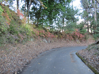
When we come down to Takamatsu community, a paved commuter road appears. In 20m or so we find ourselves at a Y crossing. Please take the right road that is relatively run straight from the direction we have come. The route almost immediately has another Y crossing whose left road is a paved way wide enough for cars, and another on the right is paved but a bit narrower for city cars. Take the right road. It goes straight to Hisari Pass 尺里峠. You can take wider road for sure, but it’s a roundabout commuter road that joins to the narrower right road in the end. The right road has more rudimentary surface with asphalt. It goes up first slowly and eventually gaining gradient. On our left when the slope is free of afforested conifers, we enjoy the magnificent figure of entire Mt. Fuji. From around here to the top of Mt. Takamatsu, when the west facing slope is clear, we’ll be greeted by elegant scenery of Mt. Fuji almost continuously. Brownie Point #6 for today. 😊 After less than 40 minutes of walk from Takamatsu Community, we reach to a fully paved Forestry Road from Yadoriki Community 寄 of Matsuda Town 松田町. Now we’re in Hisari Pass, which has a small space for car parking, maybe for 2 or 3 cars. From here there’s no pavement to the west or north.
 |
| The right road is like this. |
 |
| Mmmmmmmmmmmmmmmmm … |
Hisari Pass has another name, i.e. Dairoku-Ten 第六天. It has a small shrine. In Japan, shrines for Dai-roku-ten (in Sanscrit, Para-nirmita-vaśa-vartin) can be found only in the areas for present-day Tokyo, Chiba, and Kanagawa. Luis Frois, a Portuguese Jesuit missionary who was active in Japan during the late 16th century wrote Oda Nobunaga 織田信長, a ferocious feudal lord of medieval Japan, called himself the incarnation of Dairoku-Ten. In Buddhism, Para-nirmita-vaśa-vartin is at the highest echelon of greed-filled this world. The deity does not need any carnal exchange to have sexual ecstasy or even babies. The common Japanese moniker of this supernatural figure is Maou 魔王, i.e. Asian Lucifer … Nobunaga was killed when he almost completed his project for ending civil war age. His subordinate Toyotomi Hideyoshi 豊臣秀吉 cleverly inherited the achievement of his late boss and ended the civil war. After he reached to the top in Japanese politics, he ordered to destroy all the Dairoku-ten shrines in his domain. Maybe, his rival, Tokugawa Ieyasu 徳川家康, who moved to Edo, aka Tokyo, from Nagoya when Hideyoshi made his way, deliberately spared these shrines in his territory from annihilation … From the forestry road, there are small but steep steps that bring us to the petit shrine for the “Satan.” It’s the short cut to the top of Mt. Takamatsu. Let’s go up to say hello to the Devil.
 |
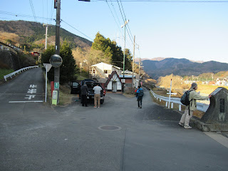
| We’re
at Hisari Pass. Could you see two small structures here? They are toilets, but I don’t recommend to use it … The wide unpaved road beyond toilets will join in the end the ridge way to Mt. Takamatsu. |
 |
| Please go up these steps, then … |
 |
| Stones, any one? |
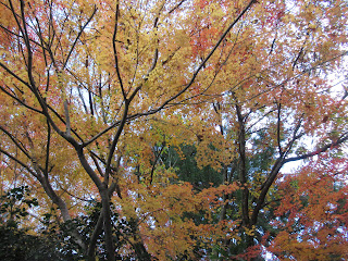
Up to Hisari Pass, the road we’ve taken is Mushizawa Kodoh 虫沢古道. From Hisari Pass to the peak of Mt. Takamatsu, the route is called Takamatsu Kodoh 高松古道. The condition of this road is standard trekking route for Japanese mountains. It is a well-maintained ridge way with enough signposts and wonderful views. We relish entire Hakone Mountains 箱根全山 and Mt. Fuji to the west. Not only that, to the east we start to admire mountains of Omote Tanzawa, such as Mt. Nabewari 鍋割山 (ASL1272.4m), Mt. Toh 塔ノ岳 (ASL1490.9m), and Mt. Oyama 大山 (ASL 1252m). Brownie Point #7 for today. 😊 Along the way, there are several colonies of oriental paperbush (Edgeworthia chrysantha) and Lindera praecox. So, in early spring we can enjoy fragrant aroma from flowers of these plants. Colonies of Perilla citriodora are also here and there. Please try to collect leaves of them from late spring in fresh green to early winter when they are completely dry and desiccated. It has citrate fragrance that can remain on you finger … Nice. Brownie Point #8. Oh, Perilla citriodora is not edible and could cause diarrhea if you swallow them. Even omnivorous deer don’t gnaw it. Please do not lick your finger after enjoying their smell! Hmmm, come to think of it, the plant is very Dairoku-ten like …
 |
| Hello! |
 |
| Lindera praecox |
 |
| Perilla citriodora |
 |
| Tanzawa mountains come into our view … |
 |
| The road becomes steeper, but well-maintained. |
The last 200m or so before the top of Mt. Takamatsu is a steep steps going up. Then, we reach to the peak of Mt. Takamatsu, ASL 801.2m. It is a very wide-open meadow. The western view of Mt. Fuji and Hakone mountains from here is stunning. To the south, we admire Sagami Bay 相模湾, Ohshima Island 大島, skyscrapers of Tokyo and Yokohama, and Pacific Ocean. To the east is Omote Tanzawa mountains. Perfect spot for lunch, especially when it does not have much wind. Brownie Point #9. After lunch, we return to Hisari Pass and take paved forestry road of Mushizawa Kodoh to the east.
 |
| Almost there … |
 |
| The peak of Mt. Takamatsu. |

 |
| We can see Odawara City 小田原. |
The Mushizawa Kodoh to this direction ends in Yadoriki Community. We bid farewell to the views of Hakone and Mt. Fuji, but continuously admire the Tanzawa Mountains now. Brownie Point #10. Not many cars come to this dead-ended forestry road. For the last leg of a full-day hiking, it’s a relaxing one-way down. In less than an hour from Hisari Pass, we enter Yadoriki Community. Mushizawa Kodoh ends at the crossing with a community road wide enough for two-way traffic system. There runs a river along this route, which is Mushizawa River 虫沢, the godparent of Mushizawa Kodoh. Keep on descending along Mishzawa River that joins with Nakatsu River 中津川 coming from Yadoriki Water Source Forest やどりき水源林. Please cross Nakatsu River at Tashiro Bridge 田代橋 and Prefectural road #710. Here is the bus stop of Tashiro Mukai 田代向. Fujikyu-Shonan Bus 富士急湘南バス has roughly one to two services per hour from here to Odakyu Shin-Matsuda Station 小田急新松田駅 (; the timetable is here). From the end of Mushizawa Kodoh to the bus stop, it’s about 30 minutes’ walk. At the foot of Tashiro Bridge on the west bank of Nakatsu River, there is a well-equipped public toilet. From Tashiro Mukai to the Station, it’s about 30 minutes’ ride. If you need the occasion, please don’t miss the chance!
 |
| Tanzawa mountains |
 |
| This part of Mushizawa Kodoh is well-paved. |
 |
| To the bus stop, please go to the right direction. |
 |
| Mushizawa River. Along this river, there is a training house for circus artists. |
 |
| On the bank of Nakatsu River. |
 |
| Please cross that red bridge over there and go
straight. You’ll find the bus stop. |
 |
| The structure of pointed roof is a toilet. |
From tomorrow (January 15) to February 6th, Yadoriki Community plans to have the 10th Wintersweet Festival. From 29th to February 20th, Nishi-Hirahata Park 西平畑公園 would have Cherry Blossom Festival … With this Omicron variant, the situation is very fluid … Please check these sites if you’ re planning to go there. If we’re lucky, we can enjoy the marvelous flowers finally for 2022 …
 |
| At least in December, the route was tranquil … |
If you find environmental issues in Kanagawa Prefecture, please make a contact with Kanagawa Natural Environment Conservation Center 神奈川県自然環境保全センター
657 Nanasawa, Atsugi City, 243-0121
〒243-0121 厚木市七沢657
Phone: 046-248-0323
You can send an enquiry to them by clicking the bottom line of their homepage at http://www.pref.kanagawa.jp/div/1644/
No comments:
Post a Comment