
Shonan area 湘南 of Kanagawa Prefecture is famous nation-wide as a fashionable sea-resort. Well, last summer we had Sailings competition in Enoshima for Tokyo 2020 Olympics. Of course, once we leave from the shore, there is inland part with farmlands and forests. I feel peculiar openness from such forests of Shonan. It may be due to vegetation for warmer climate with occasional sea-breeze. Or, I would say, it’s because of people who live near and come to spend their regular weekends in the forests. This week I tell you my adventure in one of such places. It’s Chigasaki Satoyama Park of Kanagawa Prefecture 神奈川県立茅ケ崎里山公園. It’s in Chigasaki City 茅ケ崎市 where several contemporary big names of Japanese culture for sea and summer were born and/or grew up. From this Park, we cannot observe sea. Instead, we can admire beautiful Mt. Fuji. Still, the place has the atmosphere …

 |
| #2 Bus Stop of Shonandai |
 |
| Serizawa Iriguchi Bus Stop |
 |
| Satoyama Park Entrance traffic light. Please turn right here to take the road we can see in front. |
 |
| The main entrance of Satoyama Park is over there. |
If it does not rain, the main entrance area of Chigasaki Satoyama Park has busy weekends. A wide-open paved space is for many families enjoying their badminton, dribbling succor balls, simple catch and catch, etc. On our left, there is Park Center building. They have free maps of the Park (including English version) and accept reservations for rental meeting spaces in the Park. It also has a café, called Satoyama Café. This is one of the reasons why locals visit the Park for weekends. The premise is only for weekends and holidays. It’s run by a group of farmers’ wives. They serve vegetable tempura lunch, soup noodles and curry plate at 500 yen or less. The vegetables they use is brought from their farmland harvested in the morning. It’s worthwhile visiting the Satoyama Park for this weekend lunch. The catch is, the moms are not professional chefs so that they serve their wonderful and reasonably priced lunch in limited supply. Mind you, the place is VERY popular. It’s open 11:00-15:00, but before 13:00 their lunch plate is sold out. After the meals are gone, they serve you hot coffee and cookies. Please try the place. I’ve found sweet taste of fresh winter spinach in the Udon noodle soup. It was hot and easy for my stomach in a cold January Park …
 |
| The
Entrance area. Could you see a structure at the bottom of this photo? It’s the beginning of big slide. |
 |
| The area also has a graphic map of the Park. |
 |
| The Park Center |
 |
| When the café is open, we can see this banner. |
 |
| Inside
the Park Center. They have informational displays explaining the Park and the area. Could you see people beyond the partition? That’s the café. |
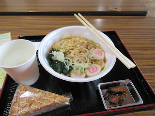 |
| My lunch. Mmmmmmmmmmmmmm |
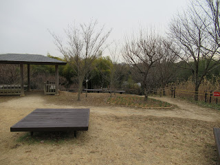
Next to the Park Center (and the café) there is a small hill, the highest point of the Park. Satoyama Park is spreading to the north from there. (For the map, here.) It is almost simply going down to the northern tip of the Park with BBQ space for summer. From the main entrance area, there is a long 70m slide popular among kids. The slide ends at the Terrace of Winds 風のテラス. Beyond the Terrace is lawned open space that is a designated heliport for emergency by the local government. The bottom of the area has a pond called Nakanotani-ike 中ノ谷池. The west bank of the pond is a steep slope reaching to the paved ridge way. This ridge path is relatively flat. If you’re a motorized wheelchair user, it’s a nice strolling route. (For non-motorized chair user, it might be a bit long walk.) Basically, it’s a single paved road ends at Park Center so that cars coming this road is only for Park Management. Otherwise, bikers utilize this quiet road for their long-ride weekend. Soon, we meet on our right another open space named “Mori-no-mura (Forest Village) 森の村 with lots of plum trees. This is more or less the end of the Park for the east of the ridge way, but the paved road continues, going down more steeply now.
 |
| The highest altitude of the Park, ASL 50m (aprrox.) |
 |
| The western
view from the “peak” of the Park. Er …if it’s a fine day, we must be able to admire Mt Fuji in the center of this photo. |
 |
| The 70m slide reaches to Terrace of Winds. |
 |
| The open space that would be a heliport for emergency. |
 |
| Nakanotani-ike.
When I’ve been there they did a maintenance for the pond so that we could not approach near. |
 |
| The paved road running along the west ridge of Nakanotani-ike. |
 |
| Before
reaching to “Forest Village,” we come to this Hitoashi Pass 一寸峠. “Hitoashi” means “just one step,” i.e. tiny. Could you see stone monuments in the right of this photo? It’s called Koshintoh 庚申塔, an ancient good luck charm built every 60 years. It’s a kind of evidence “Hitoashi Pass = Easy Pass” is an old name. Hitoashi Pass was an entrance to the community whose remains we visit next week. |
 |
| The paved road continues to … |
 |
| Forest
Village. It’s more or less the end of the Park for the eastern slope of the ridge way. |
On our left (to the west, I mean) is the continuation of Park’s forest and on our right is traditional residential area for local farmers. Their house is surrounded by big old trees. They were strategically planted centuries ago to protect from strong winds their home on the ridge way. Each house along the road is also big. In their front yard, they sell their fresh produce from the field at very reasonable price. Also during weekends, in front of their house the farmers chat with visitors, often 30sh or 40sh years old folks. The topic, it seemed to me, was dominated about “how to organically nurture soil for the next harvest,” or similar things. It’s the point of this community. Let us see how this develops in Chigasaki Satoyama Park ... Among the deep-rooted houses there is ancient Koshikake Shrine 腰掛神社 that is also enclosed by very old forest. In Japanese Shitoism, ecosystem in the sanctuary is the property of the gods. Cutting or clearing them is tabu. Now the forest of Koshikake Shrine is defined as “Natural Treasure for Chigasaki City.”
 |
| Private properties appear to the east of ridge way. |
 |
| Koshikake Shrine |
 |
| On the
ridge way, one of the houses is a café-gallery, frequented by local artists. |
The west of Park’s paved ridge road is another small valley whose western rim is next to another farming community connecting to Samukawa Town 寒川町. This part of the Park has more familiar sceneries to this blog, but with a twist. Let’s go there next week. 😊

Chigasaki Satoyama Park 茅ケ崎里山公園
1030 Serizawa, Chigasaki, Kanagawa, 253-0008
〒253-0008 茅ケ崎市芹沢1030
Phone: 0467-50-6058
FAX: 0467-50-6358
No comments:
Post a Comment