Showing posts with label 神奈川県立茅ケ崎里山公園. Show all posts

Friday, April 22, 2022

Post-report: Chigasaki Satoyama Park of Kanagawa Prefecture, April 2022, 神奈川県立茅ケ崎里山公園


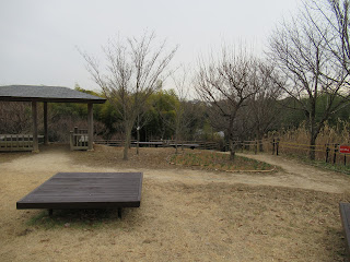
Recently, I happened to have a chance to revisit Chigasaki Satoyama Park. The forest was beautiful with various hues of spring greens. I compared the scenery with my memory of winter grey. It was January when I visited there last time ... I felt a bit strange to be in such a peaceful place under warm spring sun.


Chigasaki Satoyama Park 茅ケ崎里山公園
1030 Serizawa, Chigasaki, Kanagawa, 253-0008
〒253-0008 茅ケ崎市芹沢1030
Phone: 0467-50-6058
FAX: 0467-50-6358

http://www.kanagawa-park.or.jp/satoyama/index.html


Friday, February 18, 2022

Learning to be self-sufficient: Chigasaki Satoyama Park of Kanagawa Prefecture, 2 神奈川県立茅ケ崎里山公園 2


The west of the Park’s paved ridge road is a small valley whose western rim is next to another farming community connecting to Samukawa Town 寒川町. Do you remember Samukawa Town has Samukawa Shrine 寒川神社? The shrine’s status was the Premier Provincial Shrine of Sagami Region, an old administrative division for Kanagawa Prefecture (my post on December 30, 2016). At the corner of West Parking, nearest point to the Park Centre, there are archeological sites from BC 2500 to AD 700. Actually, from this point to the northern most part of the west ridge way scholars found several archeological facts of pre-historic Japan. People did primitive agriculture, hunted wild animals such as boars, deer, rabbits, etc, and used boats for fishing. … er, between 10000 to 1500 years ago, Japanese archipelago experienced a peculiar Holocene glacial retreat whose cause was definitely different from the other parts of the planet. It’s a different topic I may return for another forest … Anyway, during this period, villagers in the inland Chigasaki Satoyama Park had easier access to the sea. They lived good life with healthy nutrition. Since then for more than 6 millennia, the area around Satoyama Park was home of lots of people. Wow. That might be one of the reasons why ancient Samukawa Shrine is near to Chigasaki Satoyama Park. And since October 2001, the valley where western ridge road of the Park looks down eastward tries to preserve such tradition by volunteers.


The corner between West Parking and the west ridge road.
Underground of this area has lots of archeological info.

When we go down to the east valley from the west ridge way, we can see remnants of more recent agricultural village. Let’s go down to the “Forest of Heisei 平成の森“ from the open space of Main Entrance. It’s a steep slope (and steps for a short cut) surrounded by landscaped deciduous trees. This part of the Park is known by locals for bird watching. i.e. The place has a good biodiversity where birds can find lots of food. From the end of the Forest of Heisei, we can see a sort of elongated open space where a strolling path runs in the middle. This is the traces of productive rice paddies and veggie patches of yesteryears. Now the local volunteers came here to do organic farming and reviving old orchard of chestnuts, plums, etc. Let’s take the road in the middle of fields. There appears an old house on our left. It’s a reproduction of traditional farmers house in the area, named “House of the Valley (Yato-no-ie 谷の家).” Nowadays, the place serves as a community hall and resting place for visitors. I imagined this was a typical design of Yato 谷戸 villages in hilly Kanagawa Prefecture. Numerous small valleys were for producing foods, and they are protected by firewood forests. In Japanese “Ya” means valley, and “to” means households.


Forest of Heisei

A walking path runs through …

On our left is wheat.
On our right is chestnuts orchard volunteers try to revive.

House of the Valley

In front of the House of the Valley is a pond, called Serizawa Pond 芹沢の池. This was once for rice cultivation. The modern-day standard for Japanese rice production is controlling water flow to paddies. In springtime, farmers till wet or dried field while they nurture rice seedlings in swampy seedbed. They then draw water to their paddies, prepare their field for seedlings, and plant the young rice in a very shallow pond-like paddies. Normally, these processes are completed by the middle of June before hot and humid Japanese summer. When autumn comes, well-ripen, golden ears of rice bow deeply. Farmers drain the paddies to protect ripen product from typhoon flood and harvest them on a dried ground. Having said that, there are lots of spots in Japan such water control was technically difficult. In Kanagawa Prefecture, the delta of Sagami River 相模川 was famous as such challenging place untill some 70 years ago (“A Verbatim Account of Kanagawa’s Meal,” 1992). Once in those villages, farmers seeded rice directly in their pond, and harvested the ear on rudimentary boats. Chigasaki Satoyama Park may have been for a such tradition. Serizawa Pond is said to be used for this cultivation method. Now in winter, it is for families of migratory birds. Peaceful place … 

* A Verbatim Account of Kanagawa’s Meal, Series: Japanese Food Culture Volume 14, Nobunkyo, Tokyo, 1992. 聞書き「神奈川の食事」日本の食生活全集14 農文協 1992
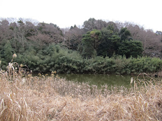
Serizawa Pond

It’s a sort of … dignified scenery, don’t you think?


Further north of the pond there are rice paddies followed by another veggie fields. Both sides of the walking path in this valley are cultivated by local volunteers. Forests begins from the east and west edges of the agricultural land. The valley we walk now is typical Yato. It would have been very efficient setting to maximize food production without fossil fuels. Moreover, by being Yato, this area has kept rich biodiversity. Swampy rice fields, then dried veggie patches surrounded by forests of both broadleaved and coniferous trees ... Variety of environment has sustained many creatures to live here. Now the volunteers are recording “animal and vegetables” they have found in the Park. As long as there is no COVID issues, they hold monthly nature observation party every 4th Sunday. If you’re interested in the occasions, just come to the open space in front of the Park Center at 10:00 in the morning. It’s open to everybody, and free of charge. Or, you can join more regular weekend activities for organic farming and nature observation parties. Please make a contact with

Chigasaki Satoyama Park Club Secretariat 茅ケ崎里山公園倶楽部事務局

www.kanagawa-park.or.jp/tigasakisatoyamaclub/index.html

email: chigasato@ganagawa-park.or.jp

They have English map of nature walk for the Park. I guess some of the volunteers may welcome non-Japanese speakers for their meeting. Oh, caution: the northern most part of agricultural fields in the valley is professional farmers’ private property. Don’t stray in, or you risk yourself for criminal offence of trespassing.

In January, all the paddies are sleeping …

waiting for the spring to come …

Northern most ridgeways of the Park has two features. West way has a small forest of cherry trees that leads us to an open space where we can admire big Mt. Fuji beyond Hakone mountains. That will be a perfect spot for spring picnic. East way ends with well-tended volunteer farm field, and BBQ space with ample parking space. BBQ opens from March 1 to 31 (weekends only), then from Aril 1st to November 30th (closed Thursdays). RSVP. Please check Park’s HP below for table availability and prices. BBQ place has the office called the House of Village (Sato-no-ie 里の家) where we can find several booklets in English. To enjoy this Park the office could be more informative for non-Japanese speakers. And finally, very important information to have a good weekend in Chigasaki Satoyama Park. This park has many toilet spots! Please grab a map from anywhere you can find in the park, or download it from their HP. They could be very useful tool, honestly. 😊

Cherry orchard on west ridge way in January.
It would be beautiful in late March …

Open space at the northern end of west ridge way.
If it is fine we can admire mountains of Tanzawa,
Hakone, and Fuji from here …

House of Village

BBQ space is closed during winter.

Another veggie place cultivated by volunteers on the east ridge.

West ridge way

Chigasaki Satoyama Park 茅ケ崎里山公園

1030 Serizawa, Chigasaki, Kanagawa, 253-0008

〒253-0008 茅ケ崎市芹沢1030

Phone: 0467-50-6058

FAX: 0467-50-6358 


Friday, February 11, 2022

Weekend Lunch in Shonan: Chigasaki Satoyama Park of Kanagawa Prefecture, 1 神奈川県立茅ケ崎里山公園 1


Shonan area 湘南 of Kanagawa Prefecture is famous nation-wide as a fashionable sea-resort. Well, last summer we had Sailings competition in Enoshima for Tokyo 2020 Olympics. Of course, once we leave from the shore, there is inland part with farmlands and forests. I feel peculiar openness from such forests of Shonan. It may be due to vegetation for warmer climate with occasional sea-breeze. Or, I would say, it’s because of people who live near and come to spend their regular weekends in the forests. This week I tell you my adventure in one of such places. It’s Chigasaki Satoyama Park of Kanagawa Prefecture 神奈川県立茅ケ崎里山公園. It’s in Chigasaki City 茅ケ崎市 where several contemporary big names of Japanese culture for sea and summer were born and/or grew up. From this Park, we cannot observe sea. Instead, we can admire beautiful Mt. Fuji. Still, the place has the atmosphere …


The access to the Park is from Shonandai Station 湘南台駅 as for the Flood Control Park of Sakai River 神奈川県立境川遊水地公園 (; my post on January 28, 2022). Though, today, we leave from the West Exit and take commuter bus services of Kanachu Bus. Go to #2 Bus Stop of Shonandai and ride Sho-17 (湘17) service to Bunkyo University 文教大学 (time table here). Get off Serizawa Iriguchi 芹沢入口 bus stop. It’s about 20 minutes’ ride. In front of you when you stand to the direction of Bunkyo University, there is a traffic light whose name is none other than Satoyama Park Entrance 里山公園入口. Turn right there. Some 400m beyond, we can see the main entrance of the Park. Chigasaki Satoama Park also has seriously ample parking spaces. It has 3 parkings for 400 cars in total. Such access itself indicates Shonan-style, I guess; car and family friendly …


#2 Bus Stop of Shonandai

Serizawa Iriguchi Bus Stop

Satoyama Park Entrance traffic light.
Please turn right here to take the road we can see in front.

The main entrance of Satoyama Park is over there.

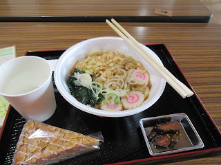
If it does not rain, the main entrance area of Chigasaki Satoyama Park has busy weekends. A wide-open paved space is for many families enjoying their badminton, dribbling succor balls, simple catch and catch, etc. On our left, there is Park Center building. They have free maps of the Park (including English version) and accept reservations for rental meeting spaces in the Park. It also has a café, called Satoyama Café. This is one of the reasons why locals visit the Park for weekends. The premise is only for weekends and holidays. It’s run by a group of farmers’ wives. They serve vegetable tempura lunch, soup noodles and curry plate at 500 yen or less. The vegetables they use is brought from their farmland harvested in the morning. It’s worthwhile visiting the Satoyama Park for this weekend lunch. The catch is, the moms are not professional chefs so that they serve their wonderful and reasonably priced lunch in limited supply. Mind you, the place is VERY popular. It’s open 11:00-15:00, but before 13:00 their lunch plate is sold out. After the meals are gone, they serve you hot coffee and cookies. Please try the place. I’ve found sweet taste of fresh winter spinach in the Udon noodle soup. It was hot and easy for my stomach in a cold January Park …

The Entrance area.
Could you see a structure at the bottom of this photo?
It’s the beginning of big slide.

The area also has a graphic map of the Park.

The Park Center

When the café is open, we can see this banner.

Inside the Park Center.
They have informational displays explaining the Park and the area.
Could you see people beyond the partition?
That’s the café.

My lunch. Mmmmmmmmmmmmmm

Next to the Park Center (and the café) there is a small hill, the highest point of the Park. Satoyama Park is spreading to the north from there. (For the map, here.) It is almost simply going down to the northern tip of the Park with BBQ space for summer. From the main entrance area, there is a long 70m slide popular among kids. The slide ends at the Terrace of Winds 風のテラス. Beyond the Terrace is lawned open space that is a designated heliport for emergency by the local government. The bottom of the area has a pond called Nakanotani-ike 中ノ谷池. The west bank of the pond is a steep slope reaching to the paved ridge way. This ridge path is relatively flat. If you’re a motorized wheelchair user, it’s a nice strolling route. (For non-motorized chair user, it might be a bit long walk.) Basically, it’s a single paved road ends at Park Center so that cars coming this road is only for Park Management. Otherwise, bikers utilize this quiet road for their long-ride weekend. Soon, we meet on our right another open space named “Mori-no-mura (Forest Village) 森の村 with lots of plum trees. This is more or less the end of the Park for the east of the ridge way, but the paved road continues, going down more steeply now.

The highest altitude of the Park, ASL 50m (aprrox.)

The western view from the “peak” of the Park.
Er …if it’s a fine day,
we must be able to admire Mt Fuji in the center of this photo.

The 70m slide reaches to Terrace of Winds.

The open space that would be a heliport for emergency.

Nakanotani-ike.
When I’ve been there they did a maintenance for the pond
so that we could not approach near.

The paved road running along the west ridge of Nakanotani-ike.

Before reaching to “Forest Village,”
we come to this Hitoashi Pass
一寸峠.
“Hitoashi” means “just one step,” i.e. tiny.
Could you see stone monuments in the right of this photo?
It’s called Koshintoh
庚申塔,
an ancient good luck charm built every 60 years.
It’s a kind of evidence
“Hitoashi Pass = Easy Pass” is an old name.
Hitoashi Pass was an entrance
to the community whose remains we visit next week.

The paved road continues to …

Forest Village.
It’s more or less the end of the Park
for the eastern slope of the ridge way.

On our left (to the west, I mean) is the continuation of Park’s forest and on our right is traditional residential area for local farmers. Their house is surrounded by big old trees. They were strategically planted centuries ago to protect from strong winds their home on the ridge way. Each house along the road is also big. In their front yard, they sell their fresh produce from the field at very reasonable price. Also during weekends, in front of their house the farmers chat with visitors, often 30sh or 40sh years old folks. The topic, it seemed to me, was dominated about “how to organically nurture soil for the next harvest,” or similar things. It’s the point of this community. Let us see how this develops in Chigasaki Satoyama Park ... Among the deep-rooted houses there is ancient Koshikake Shrine 腰掛神社 that is also enclosed by very old forest. In Japanese Shitoism, ecosystem in the sanctuary is the property of the gods. Cutting or clearing them is tabu. Now the forest of Koshikake Shrine is defined as “Natural Treasure for Chigasaki City.”

Private properties appear to the east of ridge way.

Koshikake Shrine

On the ridge way, one of the houses is a café-gallery,
frequented by local artists.

The west of Park’s paved ridge road is another small valley whose western rim is next to another farming community connecting to Samukawa Town 寒川町. This part of the Park has more familiar sceneries to this blog, but with a twist. Let’s go there next week. 😊


Chigasaki Satoyama Park 茅ケ崎里山公園

1030 Serizawa, Chigasaki, Kanagawa, 253-0008
〒253-0008 茅ケ崎市芹沢1030
Phone: 0467-50-6058
FAX: 0467-50-6358