 |
| Very
large Pyroclastic breccia in front of
us, found in Yadoriki Stream. More to it below. |
So, thanks to the birth secrets (; my post last week), what we find beneath Tanzawa Mountains is of volcanic origin, more or less. In my post for July 19, 2019, I told you my adventure with the soil in Tanzawa. Beneath the very thin topsoil, there was 40 cm or so volcanic scoria ashes due to Fuji 1707 tephra. In Tanzawa, typical soil for Kanto region is covered by the thing came from Mt. Fuji in the 18th century. Then, deeper down from that, we can encounter the proof of tectonic crashes since 13 million years ago. How can I see such an ancient mega drama? We don‘t have to dig deep down the mountain. The thing we do is simply do picnic on the valleys of Tanzawa Mountains. There are several good valleys we can visit safely especially for escaping summer heat.
 |
| Very thin topsoil of Tanzawa area |
You just hike Tanzawa Mountains and cross small mountainous valleys. The rocks and riverbeds there are the basic structure of Tanzawa that made by tectonic collides millions of years ago. The topsoil once covered such ancient earth is washed away by the stream. Often, they are tuff created by volcanic ashes and rocks spewed out by primeval under-oceanic volcanos, and piled up in the bottom of antediluvian ocean. It went through humongous pressure machine of tectonic movements which in the end pushed up the volcanic sediment above the sea level.
 |
| It’s
near Nishi-Tanzawa Visitor Centre. Lots of rocks, yeah. |
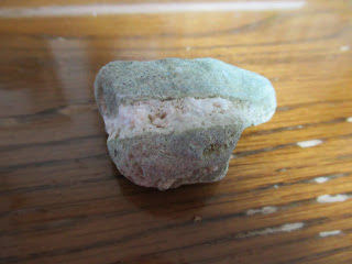
Have you noticed the riverbed often have green colour? It‘s green tuff, made by East Pacific Rim Orogeny from 26 to 5 million years ago. For the other kinds of tuffs, we know Tanzawa has fine tuff, coarse tuff, pyroclastic breccia, tuff breccia, lapilli tuff … Yadoriki stream which run through Yadoriki Water Source Forest is an easy place to find these rocks. Below is from my collection found in the riverbed of Yadoriki Stream.
 |
| It’s also green tuff with white stripes. |
 |
| Seeing
it through the microscope, I think it shows piles of ashes. |
 |
| Coarse tuff |
 |
| Lapilli tuff |
 |
| With
microscope, we can see it is made of 2-64mm lapilli with volcanic ashes. |
 |
| Tuff breccia |
 |
| Now
the size of the lapilli is larger than for lapilli tuff, but the lapilli is less than 50% of the entire rock. |
 |
| Pyroclastic breccia |
 |
| Unlike the previous
rock, now the lapilli occupy more than 50 % of the rock. |
These palm-sized rocks are probably from large ones that were cracked by landslides and continuous rapid torrent over steep slopes. When we climb upstream for water sources of mountainous valleys in Tanzawa, we can find huge rocks piling up and the amount of water flowing between boulders is smaller. One evidence that sustains the hypothesis can be found at the plunge pool of Takigo Fall 滝郷の滝, in front of the open space with picnic benches of Yadoriki Forest. The height of the fall is about 30m with average width of 2m. We can approach to the shore of the pool and observe rocky layers of earth. With large lapilli inside, we can recognize pyroclastic breccia. This waterfall is famous for its very fragile walls which killed so many climbers trying to rock-climbing. Either using aids of ropes et al or bouldering, the fragile breccia easily collapses by the weight of a climber. If a person falls down 30m on a rock, it would be an instant death. Such crumbly stone can simply become a small souvenir-sized rocks, right? In the end the rocks here are sedimentary.
 |
| The plunge pool of Takigo Fall |
The riverbeds of Yadoriki Water System can keep having small rocks even around 1000m ASL. Do you remember my adventure to Ameyama Pass 雨山峠 to Yushin Valley ユーシン渓谷 in 2019? Ameyama Pass is at ASL 957m. From the Yadoriki main stream to the Pass, the entire itinerary is on the rocks and scree. Come to think of it, they were once volcanic ashes and lapilli that went through gigantic pressure of crusts and became a mass. Since then, they continue receiving the same pressure to be pushed up to ASL 1000m and beyond. No wonder they become crumbly … Having said that, the rocks we find in Tanzawa mountains are not sedimentary alone. I’ll tell you the other kind next week. They are also very beautiful. 😄
If you find environmental issues in Kanagawa Prefecture, please make a contact with Kanagawa Natural Environment Conservation Center 神奈川県自然環境保全センター
657 Nanasawa, Atsugi City, 243-0121
〒243-0121 厚木市七沢657
Phone: 046-248-0323
You can send an enquiry to them by clicking the bottom line of their homepage at http://www.pref.kanagawa.jp/div/1644/


No comments:
Post a Comment