Showing posts with label Tanzawa Mountains. Show all posts

Sunday, January 18, 2026

Whatever Happens, Babies Are Coming: seedlings in dry river beds for winter Tanzawa


It is still at the proposal stage for a possible new project for forests in rural Kanagawa about which I said a bit last week. The theme is to assess the effects from frequent storms et al, probably due to climate change. A sudden torrential rain for a short period of time has become common these days, which could have effects on environment. Landslides and debris flows could often occur to destroy communities downstream. Especially afforested cedars where the network of root system is somehow simple and its forest floor has lesser biodiversity, the new disaster risks many be materializing easily … Such questions are certainly worth looking at. Let us see how the theme evolves in 2026 and beyond. Having said that, mini floods are habitual for rivers running down from Tanzawa Mountains even before the climate change days.

Once it collapsed, it was like this.

There is a theory the name Tanzawa 丹沢 is from classic Korean circa 1AD. According to this story, the name of the place means “many small streams.” Apt. Then, once the storm comes, these not so long but rapid flows frequently change the course. It has created wide riverbeds in deep mountains. The feature is due to the fragile soil of the area thanks to the continuing crash of Philippine, North American and Eurasian Plates. In such wide dry gravel bars, there come pioneer plants, such as Euptelea or cat’s claw, which do not care about the crumbly stone filled soil. These species should be gone once the soil becomes stable and the dominant species for the climate of the area, such as ring-cup oak, will conquer the pioneers. Alas, such transition has not happened in Tanzawa’s riverbeds.

I think this is Japanese hornbeam in winter.
Yeah, it’s another pioneer plant along mountainous streams,
but I think even this one has some limit …

Very wide dry riverbed

Euptelea in bloom

Still, it does not mean we can find only pioneer plants in Tanzawa’s riverbeds. At least baby trees sprout in a gravel-filled space, even if they will be wiped away once a storm comes. From late autumn to early spring when Kanto Region is in a dry season and Tanzawa Mountains are ‘sleeping,’ we can leisurely find variety of seedlings and rosettes there. Thinking whose babies they are is like a treasure hunt in deep mountain. For example, these are the kids I found the other day in Yadoriki stream.

Rosette for Philadelphia fleabane.
It is a naturalized plant from the US.
I noticed there are several such plants of
 foreign origin in the riverbed.
For example, maybe,

Lysimachia? also from the US, and

Sonerila dongnathamensis?
If so, it is from Thailand.

Oriental false hawksbeard. It’s Japanese native.

Plume poppy. ditto

Hydrangea macrophylla. ditto

Stephanandra incisa

Deutzia crenata.
Come to think of it,
they all love forest edge with full-sunshine.
Typical feature of ecotone, maybe …

Trachelospermum asiaticum

I think it is winged spindle.
Though now it is familiar as a garden plant,
we can commonly find it in mountains.
Our ancestors used it for painkiller.
For such usage,
the tree must have been on a stabler soil ...

Japanese Spiraea.
It also loves rocky soil, and is loved by gardeners.

I know they will be crashed by rocky debris tumbling down from the upstream, when the rainy season comes. Still, some baby maples turned their color into vivid red in dry rocks. Hmmmmmmm … this may could be an inspiration for Bonsai art. If you have a chance to visit upstream rivers in Tanzawa, just look down on your feet. Those babies are betting on the chance of their survival in this very harsh condition. Impressive.

Crashed …

Japanese maple baby

If you find environmental issues in Kanagawa Prefecture, please make a contact with

Kanagawa Natural Environment Conservation Center
神奈川県自然環境保全センター

657 Nanasawa, Atsugi City, 243-0121
〒243-0121 厚木市七沢657

Phone: 046-248-0323

You can send an enquiry to them by clicking the bottom line of their homepage at 

http://www.pref.kanagawa.jp/div/1644/

Monday, June 3, 2024

After Crashes: beautiful rocks found in the stream of Tanzawa Mountains 2


So, the base of Tanzawa Mountains has the ancient volcanic origin. “Volcanic” can be ashes, lapilli, or lava itself. The rocks that become rocks straight from lava are magmatic/igneous rock. In the riverbed of streams in Tanzawa, we can find several igneous kinds. Roughly speaking we can categorize such volcanic rocks into two families. One is extrusive rocks. They were rapidly cooled lava when it came out of the earth’s crust. In our neighborhood the familiar extrusive ones are andesite and basalt. Andesite contains more silicic acid than basalt. Andesite is often created on the edge of tectonic crash. Actually, andesite is the major component of earth’s continent, so it could be a familiar rock for some of you reading this post somewhere away from the sea. It can be found easily in riverbeds of Tanzawa too. Here is one of my collections.

Andesite
The microscopic view of the above pebble.
The white mineral is zeolite
penetrated in the lava’s holes
at the time of formation and crystalized later.

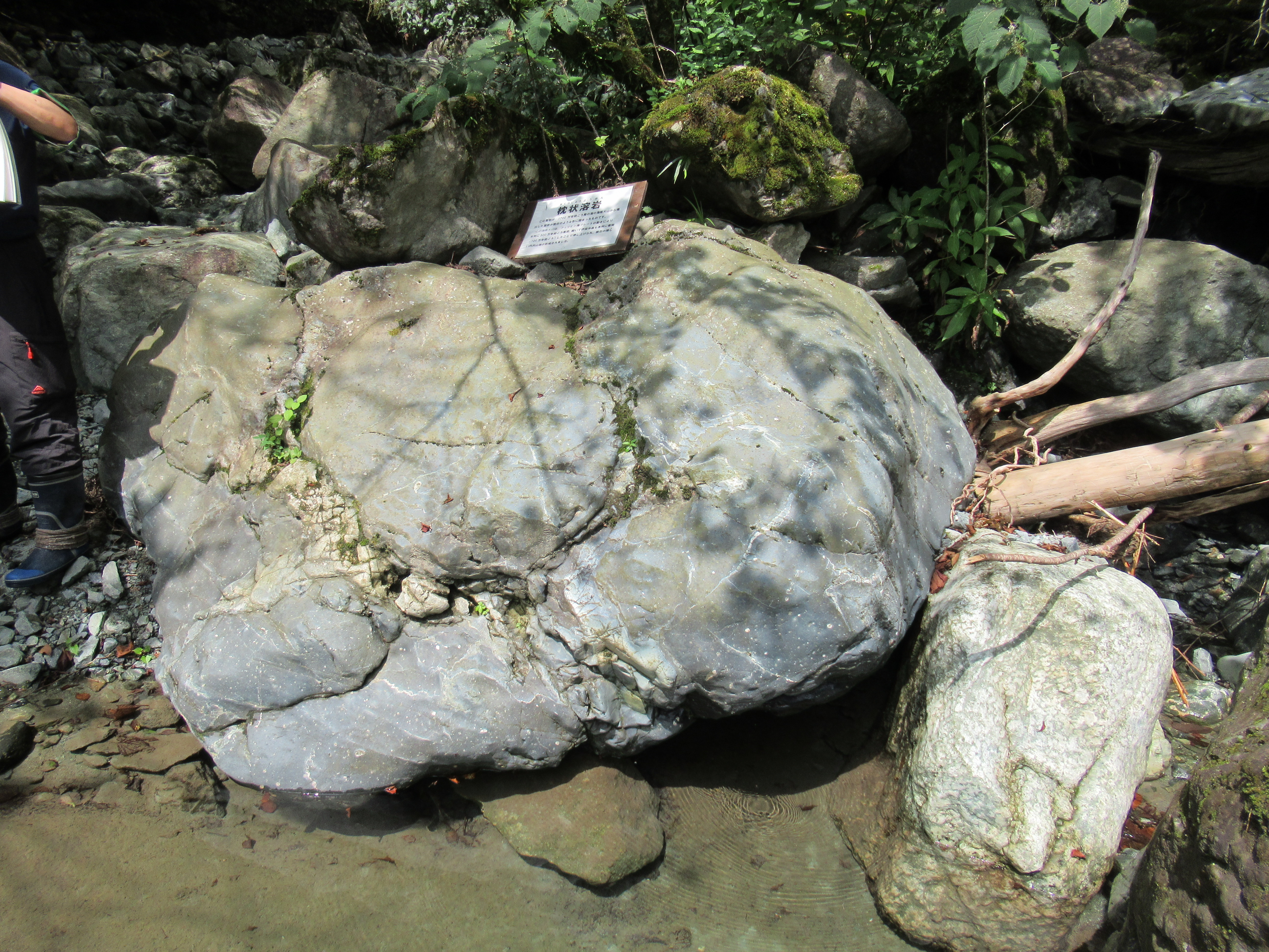
In contrast, basalt is made of smoother lava with less silica. The amount of silicic acid changes the way lava flows at the time of eruption. The less silicic, the smoother the movement of lava. It affects the way a volcano erupts. In general, the less silicic, the calmer an explosion is. At the time of burst basalt lava can be splashed over and flow rapidly that creates a volcano of gentler slope. Come to think of it, such a volcano is situated very near to Tanzawa, i.e. Oshima Island floating at the mouth of Sagami Bay. Mt. Fuji, famous for its basalt, has the origin of volcanic activity from 7 hundred thousand years ago. Compared to this, the crash of tectonic plates for Tanzawa is far older. For Tanzawa the estimated tectonic undersea eruptions began about 1.5 to 1.7 million years ago. The age of basalt we find in and around the streams of Tanzawa Mountains are definitely older than for Mt. Fuji. There is another difference between these two neighbourhood mountains. Mt. Fuji stands always on land since its birth. Tanzawa was once under sea. At the time of undersea eruption, the lava enters the mass of water directly from the crust. The surface of the lava is cooled immediately. When its texture is fluent, the instant check of water creates flow of lava like whipped cream squeezed from piping. Such lava can be solidified in a form similar to pillows, and so it is called Pillow Lava. When we walk along streams in Tanzawa Mountains, we sometimes find a pillow-like boulder. That’s a Pillow Lava containing ancient memories of the earth. It has smooth surfaces. Please touch them calmly, close your eyes, and feel the essence of the planet …

Oshima Island seen from the top of Mt. Ogusu 大楠山, ASL 241.1m (; my posts on 1, 16, 24 of April).
Could you see a wispy shadow in the middle of the ocean?
That’s Mt. Mihara, ASL 758m, famous for its very gentle ridge line.


Pillow Lava in Yadoriki Stream.

When lava is cooled slowly, it is called plutonic or intrusive rock. The creation of intrusive rock is easier to understand when we talk the origin of Tanzawa Mountains. Tanzawa is by the crash of tectonic plates, right? Philippines Sea Plate is crawling under the Eurasian and the North American Plates. Imagine the pressure inside the planet there. By the force, the lava stayed deep down is pushed up through the crack of crust near the surface, like toothpaste squeezed out of tube. It does not necessarily end up with volcanic eruption, but sometimes stays underground for a very very long time. The humongous compression continues affecting such mass of lava but in the environment of lower heat temperature, I mean, compared with that for the core of the planet. The wedged lava slowly becomes rocks. This is basically the way diamonds are created. This kind of phenomenon often occurs at the edge of tectonic collision and creates large underground geology, called metamorphic rock. Tanzawa is not an exception. About 5 to 4 million years ago, pools, or rather lakes of lava were created underground, cooled slowly, and formed metamorphic rocks. The rocks made of this process were continuously pushed up from the deep down and eventually reached the surface. The rock is ginormous. Do you remember we visited Mt. Yagura 矢倉岳, ASL 870m, located at the edge of Hakone Mountains (; my post on August 4, 2017)? When we watch the mountain from the bank of Sakawa River 酒匂川 near Odakyu Shin-Matsuda Station, don’t you think it has a particular shape, like a bump on earth? It is indeed a hump 100% made of one metamorphic rock pushed up by the pressure of tectonic crash.

Mt. Yagura is here.

The base rock of Mt. Yagura is called quartz diorite, or tonalite. In 2016, Kanagawa Prefecture designated the rock as the official rock of the Prefecture. As it has such a celebrated status, it is not so difficult to find one in the streams of Tanzawa Mountains. Here is my collection.

Tonalite. White part is plagioclase,
and black dots are amphibole and the others.

Microscopic view of the pebble.

Casually quartz diorite shows its huge face
in a riverbed of Tanzawa’s stream.
This one had
a span of at least 1m.

Not all intrusive rocks are tonalite in Tanzawa. The sedimentary rocks of vocanic ashes and lapilli do not necessarily come soon to the cooler surface of the planet after they became rock. It stayed for a while near magma, and baked for a harder rock called hornfelse. The mass of hornfelse can be found along the western ridge of Mt. Nabewari, ASL 1272.4m. Inevitably, when it crumbles, it tumbling down Yadoriki Stream, and we can find hornfelse there. It is a hard rock, and broken into peaces as if it produces sharp knives. I‘ve heard the rock was an important tool for the European Stone Age. I guess that would be the same for Japan.

There is a hornfelse in this photo.

In this blog, I several times told you Tanzawa Mountains have very fragile geology, and the forests stand on a very thin soil covering the scree beneath. By studying the tectonic origin of the area, I realized it‘s no wonder the place has such feature. Tanzawa can never have rich soil as Mississippi, but the place has its own charm, including beautiful rocks witnessing the tectonic crashes from long ago. When you hike there next time, please enjoy the scenery of rocks and boulders in Tanzawa. It tells the life of the planet earth.


If you find environmental issues in Kanagawa Prefecture, please make a contact with Kanagawa Natural Environment Conservation Center 神奈川県自然環境保全センター

657 Nanasawa, Atsugi City, 243-0121
〒243-0121 厚木市七沢657
Phone: 046-248-0323

You can send an enquiry to them by clicking the bottom line of their homepage at http://www.pref.kanagawa.jp/div/1644/

Monday, May 27, 2024

After Crashes: beautiful rocks found in the stream of Tanzawa Mountains 1


Very large Pyroclastic breccia in front of us,
found in Yadoriki Stream. More to it below.

So, thanks to the birth secrets (; my post last week), what we find beneath Tanzawa Mountains is of volcanic origin, more or less. In my post for July 19, 2019, I told you my adventure with the soil in Tanzawa. Beneath the very thin topsoil, there was 40 cm or so volcanic scoria ashes due to Fuji 1707 tephra. In Tanzawa, typical soil for Kanto region is covered by the thing came from Mt. Fuji in the 18th century. Then, deeper down from that, we can encounter the proof of tectonic crashes since 13 million years ago. How can I see such an ancient mega drama? We don‘t have to dig deep down the mountain. The thing we do is simply do picnic on the valleys of Tanzawa Mountains. There are several good valleys we can visit safely especially for escaping summer heat.

Very thin topsoil of Tanzawa area

You just hike Tanzawa Mountains and cross small mountainous valleys. The rocks and riverbeds there are the basic structure of Tanzawa that made by tectonic collides millions of years ago. The topsoil once covered such ancient earth is washed away by the stream. Often, they are tuff created by volcanic ashes and rocks spewed out by primeval under-oceanic volcanos, and piled up in the bottom of antediluvian ocean. It went through humongous pressure machine of tectonic movements which in the end pushed up the volcanic sediment above the sea level.

It’s near Nishi-Tanzawa Visitor Centre.
Lots of rocks, yeah.

Have you noticed the riverbed often have green colour? It‘s green tuff, made by East Pacific Rim Orogeny from 26 to 5 million years ago. For the other kinds of tuffs, we know Tanzawa has fine tuff, coarse tuff, pyroclastic breccia, tuff breccia, lapilli tuff … Yadoriki stream which run through Yadoriki Water Source Forest is an easy place to find these rocks. Below is from my collection found in the riverbed of Yadoriki Stream.

Green tuff

It’s also green tuff with white stripes.

Seeing it through the microscope,
I think it shows piles of ashes.

Coarse tuff

A microscopic photo of the above rock.
It’s a rock which relatively coarse volcanic ashes,
roughly 1/16 to 2mm in diameter,
piled up at the bottom of the sea,
then went through the tectonic pressure machine.

Lapilli tuff

With microscope,
we can see it is made of 2-64mm lapilli
 with volcanic ashes.

Tuff breccia

Now the size of the lapilli is larger than for lapilli tuff,
but the lapilli is less than 50% of the entire rock.

Pyroclastic breccia

Unlike the previous rock,
now the lapilli occupy more than 50 % of the rock.

These palm-sized rocks are probably from large ones that were cracked by landslides and continuous rapid torrent over steep slopes. When we climb upstream for water sources of mountainous valleys in Tanzawa, we can find huge rocks piling up and the amount of water flowing between boulders is smaller. One evidence that sustains the hypothesis can be found at the plunge pool of Takigo Fall 滝郷の滝, in front of the open space with picnic benches of Yadoriki Forest. The height of the fall is about 30m with average width of 2m. We can approach to the shore of the pool and observe rocky layers of earth. With large lapilli inside, we can recognize pyroclastic breccia. This waterfall is famous for its very fragile walls which killed so many climbers trying to rock-climbing. Either using aids of ropes et al or bouldering, the fragile breccia easily collapses by the weight of a climber. If a person falls down 30m on a rock, it would be an instant death. Such crumbly stone can simply become a small souvenir-sized rocks, right? In the end the rocks here are sedimentary.

The upstream of Yadoriki Stream.
The place is famous for its large boulders covering the riverbed.

The plunge pool of Takigo Fall

The riverbeds of Yadoriki Water System can keep having small rocks even around 1000m ASL. Do you remember my adventure to Ameyama Pass 雨山峠 to Yushin Valley ユーシン渓谷 in 2019? Ameyama Pass is at ASL 957m. From the Yadoriki main stream to the Pass, the entire itinerary is on the rocks and scree. Come to think of it, they were once volcanic ashes and lapilli that went through gigantic pressure of crusts and became a mass. Since then, they continue receiving the same pressure to be pushed up to ASL 1000m and beyond. No wonder they become crumbly … Having said that, the rocks we find in Tanzawa mountains are not sedimentary alone. I’ll tell you the other kind next week. They are also very beautiful. 😄

We’re reaching to the Ameyama Pass …
and the route is still like this.

Oh, by the way,
the riverbed in front of the Open Space near Yadoriki Bridge
 (that red one) is not natural one,
 but goes through riparian works many times.
 Reason?
 Frequent monster typhoons cause landslides often
 along Yadoriki Stream,
and block the water flow
that could trigger debris flow to the communities downstream.
 The prefectural office does continuous construction there,
 but Mother Nature always wins.

If you find environmental issues in Kanagawa Prefecture, please make a contact with Kanagawa Natural Environment Conservation Center 神奈川県自然環境保全センター

657 Nanasawa, Atsugi City, 243-0121
〒243-0121 厚木市七沢657
Phone: 046-248-0323

You can send an enquiry to them by clicking the bottom line of their homepage at http://www.pref.kanagawa.jp/div/1644/

Sunday, May 19, 2024

Crash of Titans: the origin of Tanzawa Mountains


Kanagawa Prefecture was on the epicentre for the 1923 Great Kanto Earthquake (; my post on September 15, 2023). It was Sagami Trough that was created by tectonic crush of Philippine Sea and Eurasian Plates. Such movement of earth’s crusts does not only cause mega-earthquake, but also keeps pushing up (Eurasian Plate side) and down (Philippine Sea Plate which goes beneath the Eurasian Plate) the land we’re standing daily. Now, Philippine Sea Plate goes north-west 4cm per year, and thus causes the physical stress on the Eurasian Plate by this magnitude. Such tension has been existing for trillions (or more) of years …


Over there was the epicenter.

Take Tanzawa Mountains 丹沢山地. The steep slopes of the area were once at the bottom of the Ocean whose name was even not Pacific, but Izanagi (the name of creator god for Japanese mythology). Actually, at that time Japanese archipelago did not exist. Many sections of the current Japanese islands were a part of Eurasian Plate. Huge Pressure caused by the crash of Eurasian, Philippine Sea, and North American Plates bended and torn up the upper part of the crusts. The ripped former parts of Eurasian and North American Plates were folded further that make the base of Honshu Island. When the seabed, including the present-day Tanzawa, kept on pushing the Eurasian Plate, the split part from the Eurasian Plate was bended 90° degree, and the huge area of the crust fell to form a huge valley. The dent induced a gigantic gash of sea water inland and created the origin of Japan / East Sea. Along the “shores” of newly born inland sea, the chains of volcanos activated and repeated violent eruptions.

Tanzawa Mountains are getting taller day by day.

The western part of the valley’s shore has now clearly been identified by mortal humans as an enormous fault line slicing Honshu Island. It starts from Itoigawa City 糸魚川市 on Sea of Japan / East Sea side and goes through Sizuoka City 静岡市 on Pacific Ocean side. The fault line is called Itoigawa-Shizuoka Tectonic Line. (Er, well, no surprise for this name.) In contrast, the exact location of the eastern shore of the valley is under a lively debate among scholars. One thing is sure. The area sandwiched by these two shores is a region considered to have one of the most active volcanic mountains on earth. The area has a name, Fossa Magna. Tectonic crushes make fissures on the earth’s crust. The mantle of the planetary core finds corridors to release its heat et al and melts the upper layer of the planet. Lava is made deep down, and it comes up and forms lots of lava pools which could eventually become volcanoes. Tanzawa Mountains are on one of the lava pools since they were undersea.

And so, there is Mt. Fuji.

Itoigawa-Shizuoka Tectonic Line sliced Shizuoka City continues to Suruga Bay, the deepest Bay in the Japanese territory. When the Tectonic Line dived in the Pacific Ocean, it has another name, Suruga Trough. The northern march of Philippine Sea Plate first created bulges of volcanic seabed. The underwater world had lots of eruptions spewing lapilli and ashes into the Ocean. These minerals piled up on the seabed, another eruption occurred with extreme heat, the accumulated minerals were melted, and then they were cooled by seawater. The proceed of tectonic crush continuously pushed volcanic strata beneath the Eurasian Plate. The layers went through a humongous press machine, aka the tectonic plates, and eventually sprung back upwards at the edge of tectonic crushes. Earthquake! After such shock, the seabed ended up as an island, and continued going north on Philippines Sea Plate, while occasional under/over sea volcanic eruptions.


On the Philippines Sea Plate,
Enoshima Island is standing-by for a crush.

At the end of the day, the island collided with part of the Eurasian Continent. First, the collision made very shallow sea between the Eurasian Plate and the island. It was shallow enough to be filled easily by sediments coming down from the continent and the island, while the sea became smaller as the island proceeded further. The sea was reclaimed, and the island was getting taller and taller. The Tanzawa Mountains were born. i.e. The soil of Tanzawa Mountains is made of volcanic sediments raised from the seabed where the undersea volcanos spewed lava et al.

The fossils of Smooth Cauliflower Coral
found in deep Tanzawa Mountains of Yamakita Town.
The place was once under sea …

Such origin of Tanzawa is observable from rocks we find in, say, Yadoriki Stream. Next week, I show you my collection of rocks from Yadoriki. They are beautiful, I tell you. Please stay tuned!


If you find environmental issues in Kanagawa Prefecture, please make a contact with Kanagawa Natural Environment Conservation Center 神奈川県自然環境保全センター

657 Nanasawa, Atsugi City, 243-0121
〒243-0121 厚木市七沢657

Phone: 046-248-0323

You can send an enquiry to them by clicking the bottom line of their homepage at http://www.pref.kanagawa.jp/div/1644/