Showing posts with label Microplastics. Show all posts

Sunday, February 1, 2026

I Do Not Want to Inhale: Finding microplastics in Shonan Beach


So, one fine January morning, scientists for Kanagawa Environmental Research Center gathered us, the registered ESD instructors, in a beach where Shonan Bellmare soccer team trained themselves during off-season. It was a beautiful day. The beach volleyball players engaged in their daily training routine while neighbors brought their pooches for morning stroll. A scientist instructed us, “First we situate 40cm*40cm codrato on beach.” “Please aim the collection point along the line where tide reached max, then retreated. They leave the debris on sand.” OK.

We can recognize
how far the tide came at this point with debris.
Nearer to the sea, the tidal flow washed
the fragments several times and
the beach became “seemingly” smooth and clean.
40cm*40cm was like this.

“Next, please scoop the sand within the square for about 3cm deep, and filter the contents in the sieves. We use a combination of two sieves. Above is a tool of coarser mesh with 4.74mm2. Join up a finer sieve with 2mm2 mesh below. Microplastic has, by definition, the size of 5mm less in its longest length which is often the diagonal. 4.75mm mesh could let pass a particle of this size. The lower sieve would release smaller bits, which would be defined as nanoplastics. Collecting nanoparticles is totally different issue, so we skip it today.” Sure. Let’s start sand play!

Two-story sieve system

Ready …

Go!

On the line where the tide reached max, there were lots of fragments of wood, bamboo, hard pampas grasses, and garbage of apparently artificial materials. At the point where I collected the sand not many glasses, beer cans or cigarette butts were found. Maybe, that’s good news. We collected large trash from a codrato before start scooping. In the first sieve, there remained relatively large fragments of wood and shells, and we returned them to the sand. The below is where our target remained. We damped them in a (Ahem) plastic Ziploc and brought it to the lab.

The “above” sieve.

The “below.”
They contain the thing of probably more than 5mm in size.
But they could go through 4.75mm mesh.

You may think the selection for the point of codrato would measure the level of plastic contamination higher than the average of the beach. Scientists for the Center thought the same thing and they did exhaustive study for the same beach before. “We tried several points if there is the optimum point where we can collect the microplastics in the most efficient way. Our conclusion is statistically speaking there is not much difference among locations in one beach and the amount of sand scooped. This means microplastics are scattered evenly and widely without difference in depth. Operationally, it’s good news. To think about the level of contamination, it’s VERY serious finding.” Oh yeah.

Today’s catch.

We brought the scooped materials to the lab and sorted the contents into organic things and plastics by hand, er, by tweezers to be exact. In our bag, there was no apparent porcelain and glass bits or steel wires, so the “artificial” debris was all plastics. At a glance neon green or the like of artificial coloring was not found much. So, the first impression was “Nah, problem is not serious.” Not so fast, please. The problem was, the originally white or transparent plastics absorbed or were smeared by some chemicals during their stay in water, and changed their color into similar to organic woods or the like. Deception. So, we have to identify the thing which was

a) Unnaturally geometrical, and/or

b) Looked a bit strange. 

Category b) is somehow easier to understand, isn’t it? We just trust our gut instincts. 😉

“A bit strange” things are apparent, don’t you think?

The particle in a) category was tricky as the beach was full of tiny rocks polished into something round tiny pebbles. As we know their origin was huge volcanic rocks created by tectonic movements, like andesites and tonalites, in Tanzawa. So, even when they are tiny, they keeps their characteristics of volcanic mineral. We patiently separated such pebbles from the “catch.” The plastic particles remained after this check was once the contents of beads cushions or beloved teddy bears. The main body of them was already trashed, but the staffing = plastic beads came out from the sac, drained into the stream, and ended up in the beach. During this process, they were exposed to sea water and uv-light which turned their color from white/transparent to something “organic-kind” brown. When left as such in the beach, they will be broken into smaller bits and become nanoplastics, or smaller. As they are small and light, when the wave splash kicks up them with sea water into the atmosphere, they can float in the air and end up at the bottom of the lung of mammals, humans included. Anyone cancer? Stroke? Heart attack?

The pebbles from Tanzawa, and a shell.
I plan to make them into an accessory with resin.

Another “unnaturally” plastics we’ve find looked briefly like some shell of seeds. They have a shape after the contents inside were squeezed out. Scientists told us, “It’s plastic.” Originally, they were slow-release fertilizer used massively even in commercial farms. Inside was active ingredients that seeped into the soil and one day they became empty. After reaching this stage, they started to be washed into water stream over ground, to the river, then to the sea. “Ideally, farmers side dressing their crops according to the conditions of their product. But aging problem is serious for the ag community in our prefecture. The grandparents do not have the stamina to tend their field regularly. So, they apply fertilizer contained in the plastic sac to skip regular dressing.” i.e. The problems are in forests, like Yadoriki community, and end up with the sea contamination of microplastics. Hmmmmmmmmm.

For the remnants of slow-release fertilizer,
the bit shown by the arrow is
the most easily identified in this pile of microplastics.
But here, there are roughly 10 such plastic husk.
Could you identify them?

We can analyze such debris for its chemical properties.

The result. It’s acetylcellulose.

According to the scientist of the Center, for Kanagawa Prefecture the level of microplastic contamination is apparently higher along the coast of Sagami Bay compared with the beaches to the direction of Tokyo Bay. Kanagawa’s beach facing to Tokyo Bay is almost at the exit of the Bay. Moreover, there are not many rivers pouring in. In contrast, Sagami Bay has several rivers that run down the large human settlements. Scientists surmised if the origin of the contamination is from open Pacific Ocean, there cannot be such huge difference among locale. Their conclusion is the problem in the sea is coming from the rivers passing through the land. Forests are lovers for sea. So they say. But …

Of course, we now cannot do away with the plastics for our life. We understand senior farmers need any help to continue their farming life. But, there must be some way to prevent inhaling nanoplastics that could cause any serious diseases eventually … Difficult. At least, let’s be careful before throwing away the tattered teddy bear with plastic beads …


If you find environmental issues in Kanagawa Prefecture, especially in cities and coastlines, please make contact with

Kanagawa Environmental Research Center
神奈川県環境科学センター
1-3-39 Shinomiya, Hiratsuka City, 254-0014
〒254-0014 平塚市四ノ宮1-3-39
Phone: 0463-24-3311
FAX: 0463-24-3300 
https://www.pref.kanagawa.jp/docs/b4f/index.html

Sunday, January 25, 2026

No syringes, But Microplastics: Beach clean 2026 in Shonan Beach


It’s depressing thought, but we have to face the reality before proceeding to the future, right? Our ocean is contaminated by plastic garbage. At least in Japan these days, the direct damping of plastics intentionally to sea is becoming rare. Instead, trash on land, like candy wrappers casually thrown away, is swept by rainwater to a stream nearby, then floating down the river to the sea. Speaking “Forest is a lover of the Sea.” Heck. Yeah, it is true ecologically, but the humans around these two passionate lovers don’t care how the couple nurture their love … Nay, humans are caring. Not many people these days in Japan leave the garbage in forest or on road. If you do this, the city officers and sometimes police will come to see you … Still, many non-biodegradable things drift to the ocean.

Seemingly impeccable beach

And as you know, non-biodegradable does not mean a plastic bag keeps its form as a bag forever. UV light and the other many chemical reactions mutilate the mass of plastic into particles. Microplastics are born. Micro or nano, as substance plastics are plastics and do not decompose into a natural cycle. Moreover, they chemically react with the other toxins especially in ocean where salty water and UV light do a good job for creating another toxic material from trash. Worse, as they are tiny, even if they wash up the beach, they are too small to pick up during the standard beach combing. Period. Facing the reality part is over for this post. The next is, what to do?

Too small to identify them here.

Of course, the best way is to stop supplying the “raw material” for microplastics on land. Yeah. We Lovers of Niiharu engage in weekly forest patrol and collect garbage. The common item we find is PET bottles for drinks and candy wrappers. I don’t say ours is fruitless effort, but probably we need more knowing hands to deal with the problem. Why do I think so? Well, there is an apparent change in “trophies” we can have during the beach combing in Shonan Beach.

Niiharu Lovers are patrolling.

About 20 years ago, I helped beach clean to hold the Shonan Open Water Swim Race. At that time Shichiri-ga-hama 七里ガ浜 (; my post for March 9, 2025) had still certain amount of sand beach. We could set up the starting-point for swimmers of 5km race to Katase Higashi-hama 片瀬東浜 in front of Enoshima Island 江の島 (; my post for June 30, 2017). That Friday morning, a day before the race, we collected trash, like pieces of wood came down from Tanzawa Mountains 丹沢, debris of handheld fireworks (they are dangerous for barefoot swimmers), plastic wrappers for sweets and lunch packs, PET bottles, AND old TV, tyres, used syringe needles. We’re astonished to find a corner with needles, tyres, broken TVs, and called the City of Kamakura 鎌倉市 for help. Of course, we lamented the shameful morale of somebody who damped such things there. Now that I look back, it was good old simple days. Nowadays, when we beach clean, it is difficult to find old TV et al. Actually, finding PET bottles for drinks is not so frequent. The large “catch” could be some stray fishing tools probably fishermen gave up somewhere in the waters off. Hurrah for clean beach!? Nope. Instead, we meet sand with particles of strangely vivid pink, neon blue, and plastic green. The beach is covered with microplastics. Collecting these with tongs? You must be joking.

Strange colors here and there.

One sunny day this month, Kanagawa Environmental Research Centre organized a study session on how to scientifically monitor the microplastics contamination in our beach. The idea is simple. We gather plastic particles in a unit quadrant, 40cm*40cm, of sandy beach using trowels and sieves. We then count how many MP we find in that unit, measure a probably representative specimen, then analyze chemical characteristics of it with machines. Just gathering micro plastics is simply fun. These days kids, especially in elementary schools along the Shonan Beach, engage in the activity to experience the problem in their playing ground. Good. Knowing is the first step to solve the problem. We adults are required to think about it more. Let me continue about it next week.


If you find environmental issues in Kanagawa Prefecture, especially in cities and coastlines, please make contact with

Kanagawa Environmental Research Center 神奈川県環境科学センター

1-3-39 Shinomiya, Hiratsuka City, 254-0014
〒254-0014 平塚市四ノ宮1-3-39

Phone: 0463-24-3311
FAX: 0463-24-3300

https://www.pref.kanagawa.jp/docs/b4f/index.html

Sunday, December 15, 2024

Small wonder: Haruhino-Kurokawa Forest 2


The lab by Prof. Yasuo Nihei for Tokyo University of Science is studying concentration of microplastic contamination at different points of river systems in Japan. They studied rivers in Kanagawa Prefecture as well. The researchers collected 1m3 of water from each point, then using their special tools counted the number of microplastic particles. The result was in a sense predictable. Immediately before ending in the sea most Kanagawa’s rivers go through downtown areas of large cities. At that point, a river has collected garbage from its entire basin, and so the pollution becomes worse when the lab measures the contamination. That’s that. In contrast, the water source areas of Tanzawa recorded the minimum number of microplastic particles. Long live Yadoriki Water Source Forest!

Minimum microplastic count in Yadoriki Stream

Another interesting found was when a river has large basin of suburbs, the level of microplastic contamination can be serious. The case in point was Hikiji River 引地川 whose water source is Izuminomori-Forest (泉の森; my post on February 19, 2923). Immediately out of 42ha forest, Hikiji River is sandwiched by Atsugui Naval Air Facility of US Navy and heavily developed housing area. After saying goodbye to Americans the river goes on in the middle of suburbia and commercial farms until it ends at Kugenuma Kaigan 鵠沼海岸 seaside for Sagami Bay 相模湾. When we check Google map, the basin does not have a large mass of forest, but lots of small dots of “green” for gardens of detached houses. The level of microplastic contamination turned out to be the worst in Kanagawa Prefecture for Hikiji River. Nihei Lab checked the origin of plastics, and identified more than 50% of them were from artificial lawns made of plastics. Come to think of it, these cheap alternative plastics for organic lawns are regularly stamped, kicked, and pressured by pedestrians and vehicles. They’re rapidly worn out. Inevitably, the basin that is surrounded by green plastics of artificial lawns are covered by microplastic particles. When it rains, they are washed down to the river. Hikiji River becomes sewage for microplastics. Poor river …

A stream immediate to the water source of Hikiji River.
At this point water runs through Izuminomori Forest
so that the possibility for plastic lawn particles
 comes in is minimum.
It‘s a pity we cannot keep the condition.

In November 2021, Nihei Lab checked water systems in the City of Kawasaki for microplastics. Area-wise, the most contaminated point was at the confluence point of Yakami River 矢上川 and Shibukawa River 渋川 (or, I would say heavily constructed Canal) in the east of Hiyoshi Station, near Hiyoshi Campus of Keio University. It was in the basin of Tsurumi River. Checking Google Satellite Map, the basin of these two rivers is heavily populated downtown. Lots of plastic trash would pour in to the rivers. They eventually push up microplastic contamination of Tsurumi River. The lab also studied the area around Shinyurigaoka Station of Odakyu Line, which is in the basin of Tama River. Compared with the studied point for Yakami River, the area is more residential with a large golf course, university campus, and TV studios which provide more green in satellite photo. Moreover, the local shop owners of commercial areas of Shinyurigaoka area are regularly clean their area for customers visiting a comfortable environment. Unfortunately, the place was still contaminated, though not as for Yakami River. Moreover, the pollution was heavier for pure residential areas than for commercial areas (e.g. golf courses) or business premises (like shopping areas). In such neighborhood, the clean-up effort is completely entrusted with the homeowners of suburbia. Er, well … (; my post on November 24).

One of the forests in Shinyurigaoka area.
 It’s small, but maintains the remnants of
yesteryear’s biosphere for Tama Hills.
It’s completely surrounded by housing.

Nihei Lab also measured the contamination at the confluence point of Asao 麻生川 and Tsurumi Rivers. According to the YAMAP Basin Map, the basin for this point originated from the south slopes of Haruhino-Kurokawa Forest. With Google Map, the area is also crowded by housings but not as heavily as Shinyurigaoka area, or the basin of Hikichi River. For easy garden-maintenance, it would be understandable for homeowners in Kurokawa area also love to use plastic lawns et al, wouldn‘t it? Lots of microplastic could be found in the confluence ... Nah.To everybody‘s surprise, the river water from Haruhino-Kurokawa Forest はるひ野-黒川の森 has one of the lowest contamination of rivers in Kanagawa Prefecture, standing together with water source areas in Tanzawa.

Water source area for Asao River
in Haruhino-Kurokawa Forest

There would be many reasons why they are so. Yeah, rivers from Kurokawa Forest goes through housing areas before joining Tsurumi River. But the households in Kurokawa area include old families that have lived there for more than a century. Of course, there are lots of new comers in their neighbourhood. In the end, from Kurokawa Station to Shinjuku Station it takes only 30 minutes. Many urban commuters whould love to move in. But strong local tradition may have protected the enviroment from the invasion of plastic lawns. Veteran locals in Haruhino-Kurokawa area are the people who created volunteer associations managing the Forest. Their leadership must have done a very special thing. And their activties provided scientifically endorsed result for the environment. Wow.

When we enter Haruhino-Kurokawa Forest
from Haruhino Station, we first meet
with a ridge way running
along Metropolitan Road 18
 that is the border between Kanagawa and Tokyo.
The ridge way is an old commuter route
carrying products of Kurokawa Area
to Hachioji or Edo (Tokyo) for centuries.
Now it is a nice strolling path for locals.

And the maintenance of this old route is done
 by local volunteers who invite mates
to do the weekend task.

Well-controlled undergrowth along the route.
Good job!

In the ridge of Kurokawa Forest,
there is one open space with benches.
From here to the south, or to the left of this photo,
is the basin for Asao River.
It‘s a good place to have lunch
if you spend your weekend in Kurokawa Forest.

To reach to the ridge,
we take this road climbing
from the bog for the water source.
It is well-maintained road easy to walk.
This tells the endeavor of volunteers.

Looking the basin of Asao River
from the ridge way of Kurokawa Forest.

So, if you‘re planning your Christmas holiday stroll with your loved-ones in Tokyo megalopolis area, please think about visiting Haruhino-Kurokawa Forest. The starting point is either from Haruhino はるひ野 or Kurokawa 黒川 Stations of Odakyu Tama Line 小田急多摩線. From Haruhino, please turn right at the corner of Buddy Sports Kindergarten located at the end of station square. Please go straight, and you‘ll find steps going up which is the beginning of the forest. From Kurokawa Station, please go first to Farmers’ Market Ceresamos, open 10:00-15:00. They have a good choice for veggies, garden plants, and fruits from local farms. They also sell tofu, fish and meat made in Kanagawa. The road runninng to the west from Ceresamos leads us to the an experimental farm of Meiji University. Along this road, on your right is the mass of trees which is Haruhino-Kurokawa Forest. We can meander into forest from whichever road goes to the north from the road. If you lose your way, just return to your starting point, which is within half-an-hour train ride to the downtown Tokyo. Not bad, huh?

Haruhino Station

The open space in front of Kurokawa Station

Ceresamos

Oh, I have to add this. One of those houses surrounding the forest is the parents‘ place for Takefusa Kubo, the midfielder for La Liga Real Sociedad, who is murmured to be the next Messi. The soccer clubs for kids around Haruhino-Kurokawa area are constantly created Japanese star footballers for Japanese National Teams. Kaoru Mitoma for Brighton & Hove Albion F.C. also spent his kid‘s days not far from here. Mini-footballers of the area are running everyday in their microplastic-free pitches near the Forest. It might be another miracle of Haruhino-Kurokawa Forest. 😉

The blue and white bldg. is
Buddy Sports Kindergarten near Haruhino Station.
In November, they were cerebrating
their teenage alumni who newly obtained
 seats for teams of J League.
The tradition continues ...


If you find environmental issues in the City of Kawasaki, please make a contact with 

Environment Bureau 川崎市環境局環境対策部環境保全課
1 Miyamoto-cho, Kawasaki Ward, Kawasaki City, 210-8577
〒210-8577 川崎市川崎区宮本町1
Phone:044-200-2516
Fax:044-200-3921 
30hozen@city.kawasaki.jp

Friday, February 10, 2023

Everybody Loves Green Parks: Izumino-mori Forest and Hikichi River 泉の森と引地川


This week, I’ll tell you my adventure in Izumi-no-mori Forest 泉の森, which is the source for microplastic floating Hikichi River 引地川 (; my post last week). For the sake of honor for Izumi-no-mori Forest, the microplastics we find in the downstream of the River is not necessarily started at the source. Rather, the main culprit would be the environment the river runs in. Telling you the truth, until I visited Izumi-no-mori Forest, I did not think Naval Air Facility Atsugi, the US Navy’s base camp, is very near, actually about 1km south to, the Forest. Hikichi River runs sometimes eastern edge of the Camp. I know Americans love astroturf … Anyway, I found plastic garbage already floating in Hikichi River at the exit of the Forest. Everybody should be aware of the result of such casual trashing of the environment, I presume.

Plastics floating outside Izumi-no-mori Forest

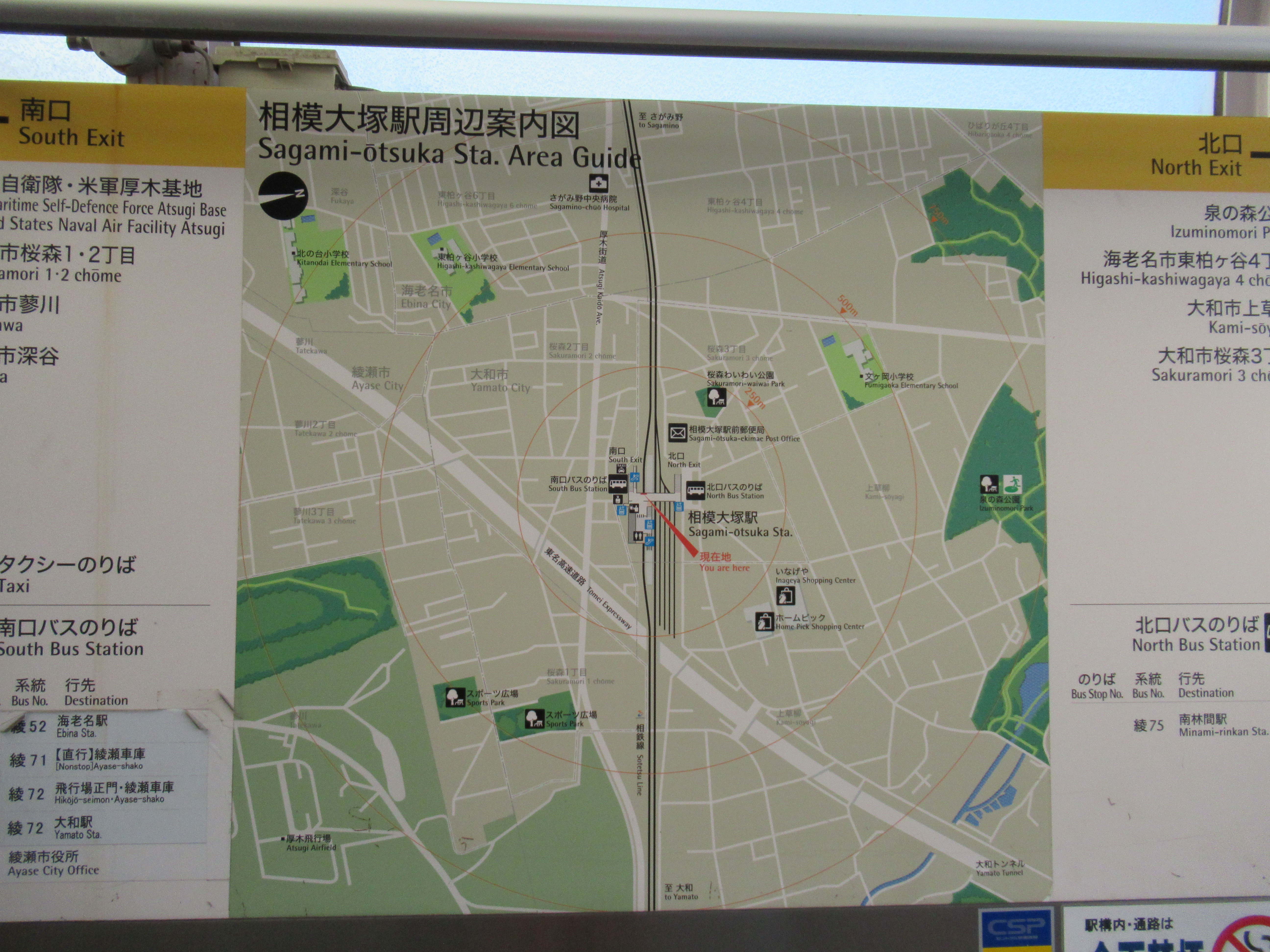
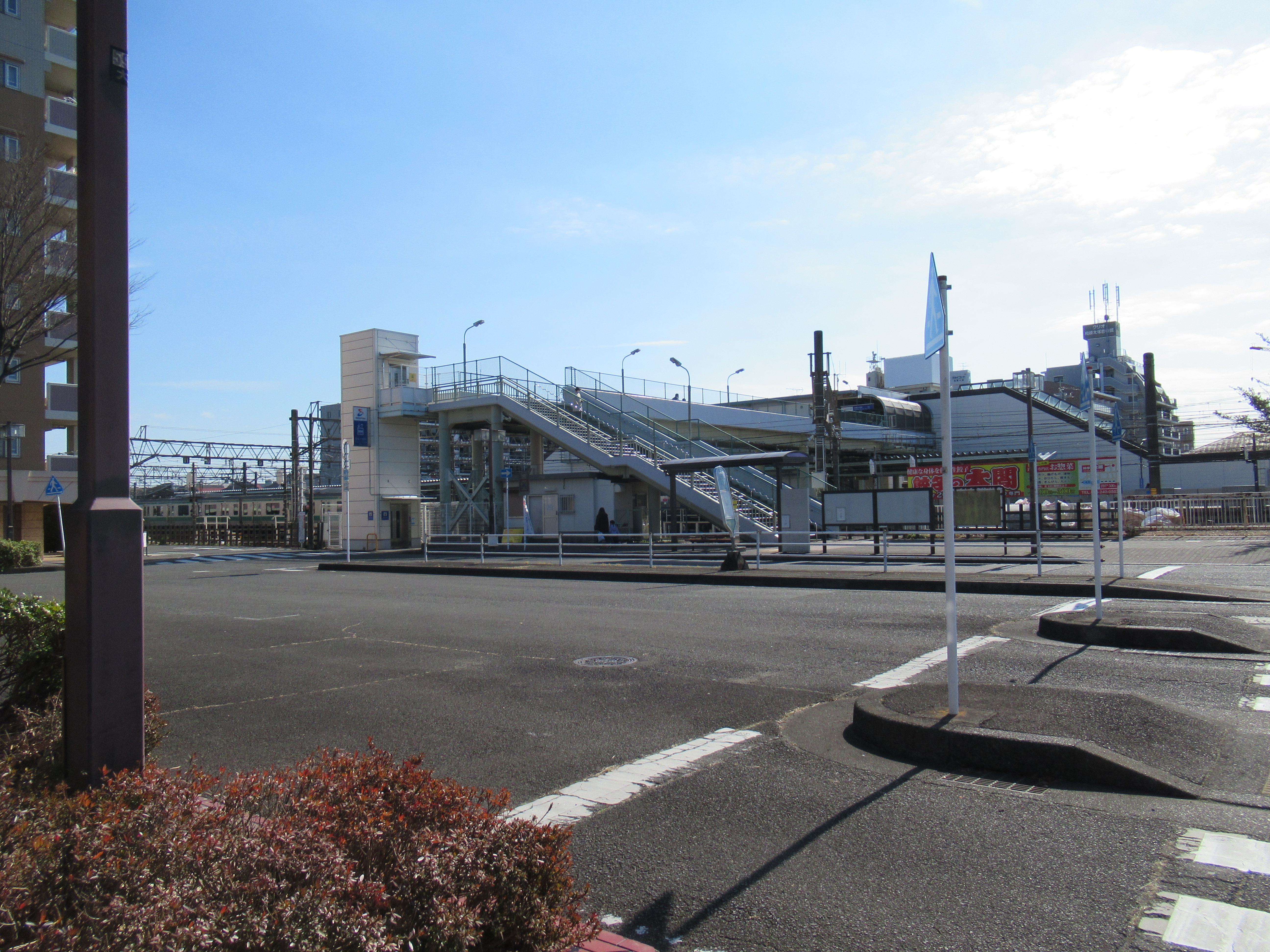
So, the nearest public transport facility going to Izumi-no-mori Forest is the same for Naval Air Facility Atsugi, which is Sagami-Otsuka Station 相模大塚 of Sotetsu Line. Tsuruma Station 鶴間 and Yamato Stations 大和 of Odakyu / Sotetsu Lines are also in walking distance to the Forest. In addition, Izumi-no-mori Forest spreads to both sides of Route 246 (; my post on March 17, 2017). The southern edge of the Forest is Tomei Express Way. As the place has ample car parking spaces, you can drive to the Forest and enjoy a relaxed stroll there. On foot, the access from Sagami-Otsuka Station is nearest. Let’s take this route. Simplest would be leaving the station from the north exit, and keep to the north in suburbia of ordinary houses. The distance between the Sagami-Otsuka Station and the Forest is not much, about 500m. The Forest is large so that you eventually bump into the edge of it even if the point you reach does not have a road into the forest. When you reach the forest rim, just walk along the road between the forest and the houses. You’ll meet the First or Second Parking for the Forest. Welcome to Izumi-no-mori Forest!

The map of the area shown
outside of the ticket gate of Sagami-Otsuka Station.
 The station is in the center of this map.
 Southwest corner is  Naval Air Facility Atsugi,
 and Northeast corner is Izumi-no-mori.
The north exit of Sagami-Otsuka Station
Outside the station,
there is this map for Izumi-no-mori Forest.
 We can use this map to the forest.

Eventually, we reach the rim of the forest like this.

The Second Parking

The larger First Parking

Though its name does not contain “park,” Izumi-no-mori Forest has the design similar to city parks such as Shiki-no-mori Park 四季の森公園 (; my post on June 26, 2020), Takane-Park 高根公園 (my post on June 15, 2018), and Yokohama Children’s Amusement - Botanical Park 横浜子供遊園地・植物園 (; my post on November 4, 2016). Many routes in Izumi-no-mori Forest are wide enough and relatively flat so that wheelchair users could enjoy nature as well. The entire land for the forest is lent indefinitely by landlords to Yamato City 大和市. So, visitors are expected to “behave” in a private property. Beyond the parking space, there are two old traditional houses that serve as historical museums of Yamato City. Both houses were transferred from the other part of the City in order to preserve them as heritage sites. One is the house of Ogawa Family that was built during the first half of the 18th century. Another is the house of Kitajima Family built in the early 19th century. By visiting these two houses, we can know the 100 years has made difference in the design of the house. The newer Kitajima house has a more robust structure, and equipped with spaces for sericulture. Sericulture and silk were the main industries for the early industrial revolution in Japan. The contrast between these two houses could say the process of economic development of Japan during the industrialization. Beyond the museum area, there is a BBQ space which has the larger First Parking. Especially after COVID, the place became very popular. Many people enjoy casual outdoor parties there these days. RSVP (; for details, here).

The house of Ogawa Family

The house of Kitajima Family

The BBQ place

Northwest of the Forest, beyond Route 246 is the area for the water source of Hikichi River. We can visit there from the BBQ place. Go down the road from the BBQ place and in front of us is a valley that runs beneath the flyover of Rote 246. The pedestrian routes go along the valley, and we can find two ponds almost immediately beyond the overpass. The ponds are actually springs. The area around the ponds and the small stream from it are off limit, sealed off by wire fences. Kanagawa Water Supply Authority oversees management and preservation of the place, since until 1992 the place supplied tap water to about 1900 households surrounding the north part of the Forest. Now the water from the Forest does not enter the water supply system as Sagami and Sakawa Rivers do the enough job for the area. Compared to the Southwest part of the Forest, this side is “deep” forest. Though, many broadleaved trees were affected by Oak Tree Wilt and some were on the verge of falling. The management of the Forest sealed off many strolling paths in order to prevent fatal accidents (; my post on August 23, 2019). Please follow the warning signs when you walk there. Those trees are large, and your cranium can easily be flattened when they come down over your head!

To the under-overpass

Under 246 is like a playground for kids.

The road is in general wide
and well-maintained inside the forest.

There is birdwatching station for observing birds
 coming to the water source pond.

The water sources are sealed off.

And a grey heron relaxed near the pond
… do we call it as “he’s in a cage”?

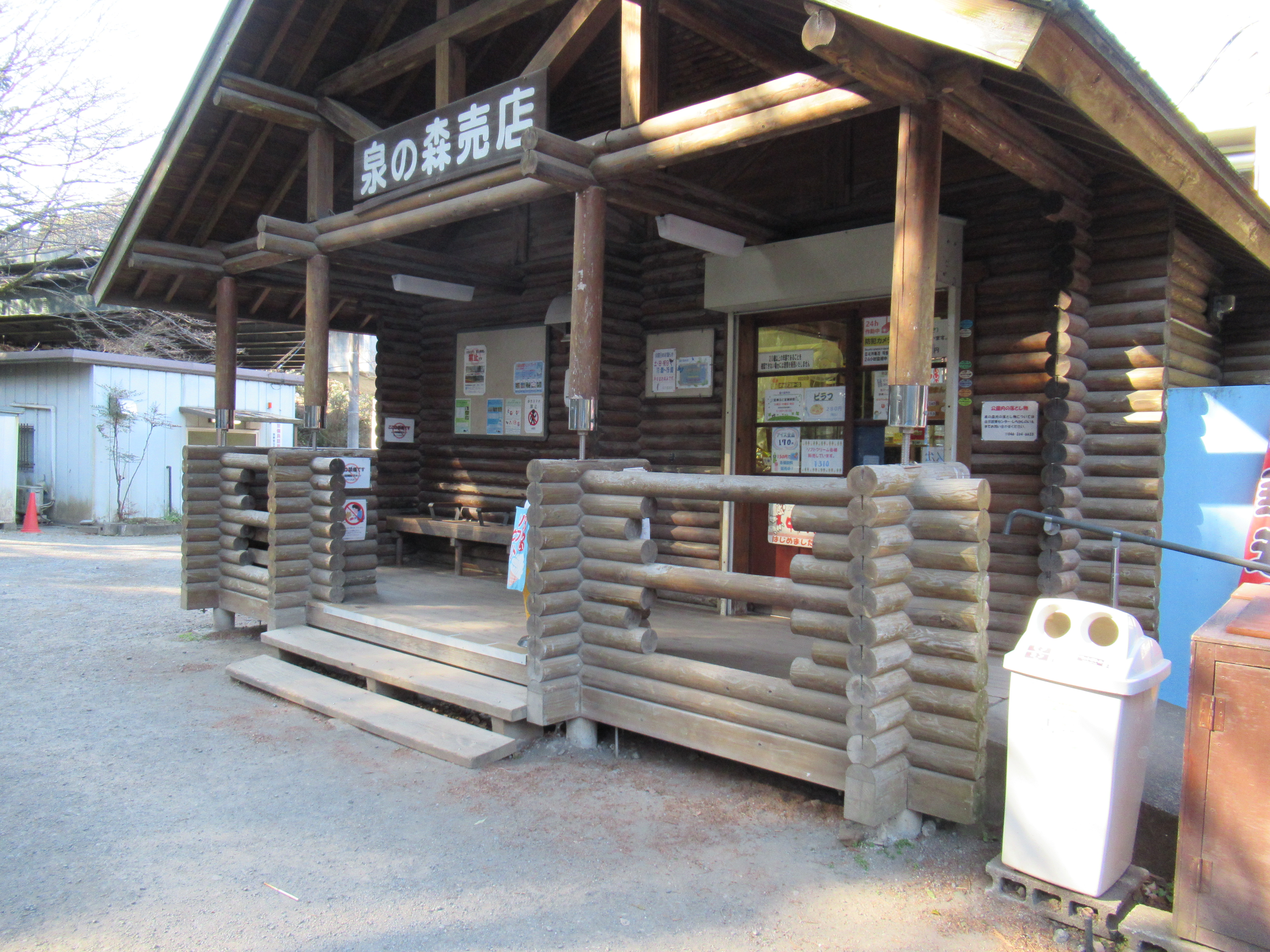
Southeast side of the 246 overpass starts with an area that has the administration cottage (“Shirakashi-no-ie”), a small shop, a police station, and a restored water mill. From the admin office, you can have a hardcopy of the map for the forest. The place also serves as a mini nature museum giving us information about the biosphere of the forest and the surrounding area. It also has the latest news from volunteer organizations that help the management of Izumi-no-mori Forest. If you’re living near there and interested in fieldworks for the forest and the stream, you can find info how to join them, etc. Oh, one important thing. Izumi-no-mori Forest equips toilets here and there, but the area surrounding the admin office has the largest numbers of it. Don’t miss your chance.

A shop and a police station

An admin-cum-museum cottage

Inside of the cottage is like this.

Water mill

In front of the admin area are landscaped streams that lead water from the source to Hikichi River. They have nice semi-paved promenades along the streams where lots of families have a leisurely walk for sunny weekends. The very end of this landscaped stream is a pond named “Bamboo-leaf oak Pond.” The place serves as a regulating reservoir to prevent flood from Hikichi River. It is allowed to fish there provided you don’t do lure fishing. During winter we can find lots of migratory winter birds floating on the pond. The place is famous for amateur photographers of wild birds. During winter they jostle each other for the best position for their perfect shot of mallards et al. The pond ends with a overflow dyke that is also the end of Izumi-no-mori Forest. Beyond the dyke is Hikichi River.

They built this nice suspension bridge
 over the landscaped stream.

Many people enjoyed the waterside.

And a row of photographers focusing on …

Eurasian Pigeon.

Great Cornmorants were also there.


The dyke which is the end of Izumi-no-mori Forest.

The southwest embankment of the dyke, there is a small forest of bamboo-leaf oaks (Quercus myrsinifolia). The place is considered to be a few remaining climax forest for Sagamino Plateau 相模野台地. Sagamino Plateau is a geological area sandwiched between Sagami River and Sakai River 境川 (; my post on January 28, 2022), ended around the border between Yamato and Fujisawa Cities. The plateau did not have good water sources for human consumption. During pre-industrialization people did farming on the Plateau, not rice cultivation, which was at that time an implicit sign of “poverty.” In the climate for Sagamino Plateau, the climax forest should be dominated by evergreen bamboo-leaf oak but people cut them off for their more convenient trees. They afforested their hills with sawtooth oaks, jolcham oaks, and coniferous trees. These oaks became good charcoal, the main fuel for people before imported oil dominated the economy. Their leaves supplied good compost for tobacco cultivation, the main cash crops during the period. Coniferous trees were sold for housing materials. Not many naturally climax forest remain now on Sagamino Plateau. The forest in Izumi-no-mori is a rare remnant of natural forest before people used intensively their land for their livelihood. (I won’t say it’s a virgin forest. Who knows if it has never experienced human intervention!) Kanagawa Prefecture designate the place as Prefecture’s Natural Treasure that should be protected “as is.”

Natural Treasure of the Prefecture

… looks ordinary, but …

Leave the dyke and walk the promenade along Hikichi River, we proceed under the flyover of Tomei Expressway, and enter “Fureai-no-mori ふれあいの森” which is a landscaped city park along Hikichi River. The end of Fureai-no-mori is almost the beginning of the main pedestrian way to Yamato Station. The other fine weekend when I took this route, the Forest, especially around the admin office to the Park and Yamato Station, welcomed many families and groups of friends. I even had a feel of “congestion.” The greenery and riverside are loved by locals quite a lot ... The reason why such seemingly ordinary forest of bamboo-leaf oaks is designated Natural Treasure is the area’s historical difficulty for the access of water sources. The scarcity of water, together with its location relatively near to Tokyo and Yokohama, made secretly unique the area of Sagamino Plateau and Hikichi River. Why does Hikichi River run through housing suburbs, and Naval Air Facility Atsugi? Why does the place not have many deep forests, compared even to Yokohama? And why does Hikichi River let microplastics float that much? Peaceful rows of family houses carry old, and contemporary, burdens, but in any case, we all love quiet strolls in the forest and along the river ... Oh, in some corners of Japan, people have started to discuss lawmaking to prohibit usage of astroturf, in order to stop microplastic contamination getting worse. The new chapter for Izumi-no-mori Forest and Hikichi River may start not before long.

To Fureai-no-mori

Under the Tomei Expressway is like this.

Brown-eared Bulbul were neatly drinking from Hikichi River.

Fureai-no-mori

There are signs showing us the direction to Yamato Station.

If you find environmental issues in Kanagawa Prefecture, please make a contact with Kanagawa Natural Environment Conservation Center 神奈川県自然環境保全センター

657 Nanasawa, Atsugi City, 243-0121
〒243-0121 厚木市七沢657
Phone: 046-248-0323

You can send an enquiry to them by clicking the bottom line of their homepage at http://www.pref.kanagawa.jp/div/1644/