Showing posts with label Urbanization. Show all posts

Sunday, November 23, 2025

Updating a Traditional Life: Miura Peninsula and Shiba Seaside Megumino-sato 柴シーサイド恵みの里


To Tenjin-jima Marine Biological Garden 天神島臨海自然教育園, we took bus sneaking through the edge of hills going down to Sagami Bay. Miura Peninsula is basically like this. Hills or petit mountains bear down on the seashore which is mainly rocky. The geography actually starts from Yokohama. Beyond the south border for Yokohama are 4 cities, Fujisawa, Kamakura, Zushi, and Yokosuka. Among them, Kamakura, Zushi, and Yokosuka are geologically a part of the Miura Peninsula, so is the communities in the south Yokohama. They do not have much flat land. Behind the touristic coast are hills where now mainly residential area covers the steep slopes and not so wide ridges. Sometimes, the original forests remain like Mt. Ogusu (; my posts for April 2024) and Hiromachi Ryokuchi (; my posts for March 2025). Before when Japanese economy was mainly of agriculture especially rice cultivation, such given condition of small space for rice paddies was not so enjoyable. Inevitably, old communities in Miura Peninsula traditionally have engaged in fishery and procured agricultural products with cash (Oral Record for Kanagawa’s Table 聞き書き神奈川の食事, in “Collected Works for Japanese Traditional Diet, vol. 14 日本の食生活全集 14,” Toda City, Nobunkyo 農文協, 1992, ISBN 978-4540920028).

Near Marine Biological Garden.
People establish themselves in
 a narrow street run between
the steep slope and seashore.

So there are the Sajima Fishing Port and the ethnographical exhibitions in the museum of Tenjin-jima Marine Biological Garden. This is true even for Yokohama. The City of Yokohama, of 3.8 urban people with a large container terminal for international trade, has a fisheries cooperative, proudly call themselves City of Yokohama Fisheries Cooperative. Guess where their office locates. Yep. At the beginning of geological Miura Peninsula. They are in Shiba Town 柴 of Kanazawa Ward 金沢区. Shiba Town is next to Kanazawa Town where Shomyoji Citizen Forest 称名寺市民の森 (; my post for December 4, 2015) and the remnants of the oldest libraries in Japan, Kanazawa Bunko 金沢文庫. Shiba Town is an old community. In the place we’re going to visit this week they have a Koshin-zuka 庚申塚 built during the 18th century. Koshin-zuka was constructed based on the belief for Taoism imported from China around the 15th century. Taoists said once in 60 days, there comes a day of Koshin when 3 bad worms in human body tattle the bad behavior of their landlord on a mighty god in heaven. To prevent the consequence of such snitch, on the day of Koshin people had a mini festival without sleep. When people had held such worship for 3 years of 60 Koshin days, the community built a monument called Koshin-zuka as a protective diety for the village, warding off the bad spirits to enter. Such folk religion was very common during the 17th and the 18th century, and lots of Koshin-zuka was constructed all over Japan. Now many are removed for development. But if a community is old and old families established themselves there centuries ago, we can find Koshin-zukas (yeah, plural) somewhere. Shiba Town is surely such place with Koshin Zuka.

The yesteryear’s way of life for Sajima Fishing Port

Koshin-zuka for Shiba Community

From the hill for Shomyoji Temple Citizen Forest, the slope rapidly goes down to Tokyo Bay where we can find a popular amusement park called Hakkeijima Sea Paradise 八景島シーパラダイス. In front of the Sea Paradise, there is Shiba Fishing Port with Fisheries Cooperative. People in Shiba has been fishermen for centuries. They also harvested veggies from small field on the ridge, in the forest continuing from Shomyoji Citizen Forest. The fishermen had difficulties to find a place for rice paddies, the most important ag product in Japan and once treated as money for centuries. Villagers of fishing community made do with vegetables for home consumption from the small veggie patches. Their farmland was only in the forest covering the ridge. Water was/is scarce. Industrial revolution gave the fishermen chances to earn cash nearby from office or factory jobs, but they still cannot cultivate rice. Life there was hard. Then, in the second half of the 20th century, the community had influx of new members from housing development. They were/are city rats. The new and old members of Shiba community did not have a contact. Meanwhile, the number of people who engaged in traditional fishery-farming was dwindling. This was Yokohama. If you like, there were/are lots of office and factory jobs. By the way, over there in front of the fishing port is the leading factory of Nissan. Why bother the old thing? The farmlands on the ridge in the forest were neglected, then abandoned.

Shiba Fishing Port

I don’t know what made them change their mind. But the historical fact is like this. The old community of Shiba thought such situation was not good. In 1988, they asked the Prefectural Office help for change. In 1990, the Prefecture designated the ridge area of abandoned farmland and the forest Land Improvement District for agriculture. The Office let the Shiba people form a committee to plan the land improvement project. Next year, actual implementation of the project started, and completed 15 years later in 2006. The work included the idea of minimum disturbance over the ecosystem of water-scarce area. The soil of the area was not moved. The precautionary design was applied for preventing landslides from steep slopes. The area has become a model case for the Prefecture and the City of Yokohama for agricultural development involving the old and new communities of the area. New community? You may think. That’s the point of this place, called Shiba Seaside Megumino-sato 柴シーサイド恵みの里, or Shiba Seaside Village of Blessings. Let’s go there next week😉

Shiba Town is pasted on a very steep hill.

If you have any questions about Yokohama’s Green Tax and Green Up Plan, please make a contact with

Strategic Planning Division, Green Environment Bureau, City of Yokohama
横浜市みどり環境局戦略企画課

Phone: 045-671-2712
FAX: 045-550-4093 

Friday, February 10, 2023

Everybody Loves Green Parks: Izumino-mori Forest and Hikichi River 泉の森と引地川


This week, I’ll tell you my adventure in Izumi-no-mori Forest 泉の森, which is the source for microplastic floating Hikichi River 引地川 (; my post last week). For the sake of honor for Izumi-no-mori Forest, the microplastics we find in the downstream of the River is not necessarily started at the source. Rather, the main culprit would be the environment the river runs in. Telling you the truth, until I visited Izumi-no-mori Forest, I did not think Naval Air Facility Atsugi, the US Navy’s base camp, is very near, actually about 1km south to, the Forest. Hikichi River runs sometimes eastern edge of the Camp. I know Americans love astroturf … Anyway, I found plastic garbage already floating in Hikichi River at the exit of the Forest. Everybody should be aware of the result of such casual trashing of the environment, I presume.

Plastics floating outside Izumi-no-mori Forest

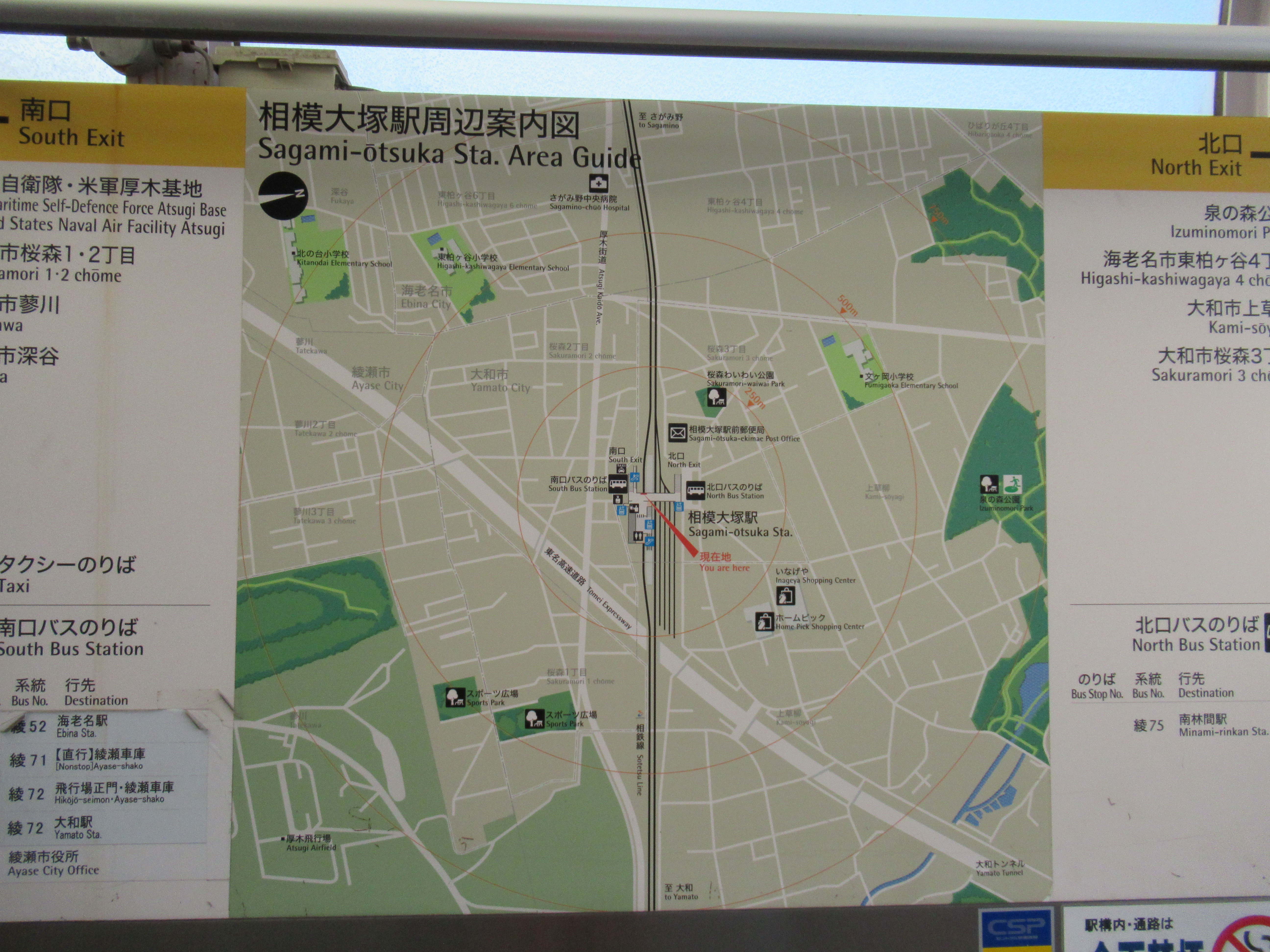
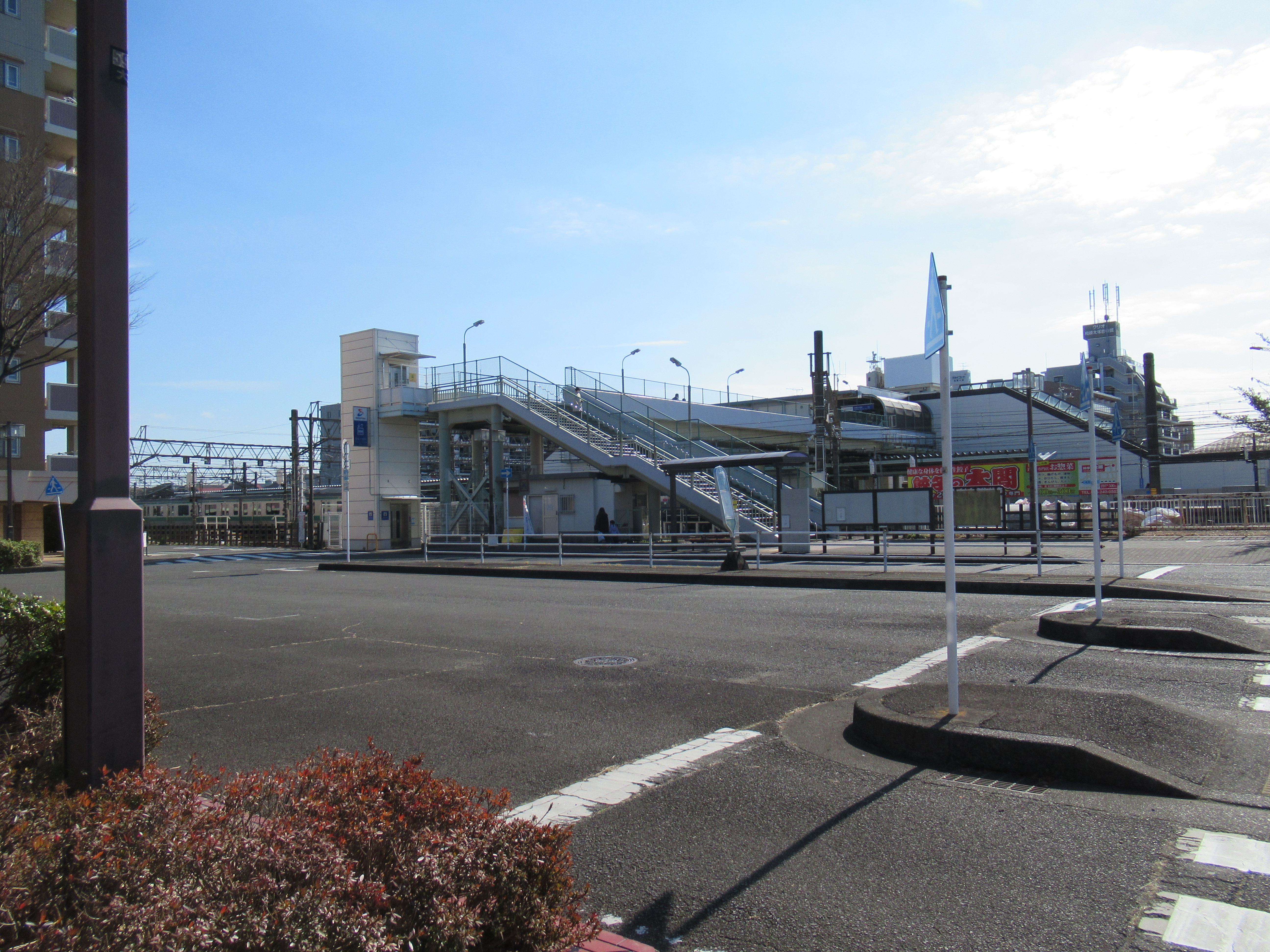
So, the nearest public transport facility going to Izumi-no-mori Forest is the same for Naval Air Facility Atsugi, which is Sagami-Otsuka Station 相模大塚 of Sotetsu Line. Tsuruma Station 鶴間 and Yamato Stations 大和 of Odakyu / Sotetsu Lines are also in walking distance to the Forest. In addition, Izumi-no-mori Forest spreads to both sides of Route 246 (; my post on March 17, 2017). The southern edge of the Forest is Tomei Express Way. As the place has ample car parking spaces, you can drive to the Forest and enjoy a relaxed stroll there. On foot, the access from Sagami-Otsuka Station is nearest. Let’s take this route. Simplest would be leaving the station from the north exit, and keep to the north in suburbia of ordinary houses. The distance between the Sagami-Otsuka Station and the Forest is not much, about 500m. The Forest is large so that you eventually bump into the edge of it even if the point you reach does not have a road into the forest. When you reach the forest rim, just walk along the road between the forest and the houses. You’ll meet the First or Second Parking for the Forest. Welcome to Izumi-no-mori Forest!

The map of the area shown
outside of the ticket gate of Sagami-Otsuka Station.
 The station is in the center of this map.
 Southwest corner is  Naval Air Facility Atsugi,
 and Northeast corner is Izumi-no-mori.
The north exit of Sagami-Otsuka Station
Outside the station,
there is this map for Izumi-no-mori Forest.
 We can use this map to the forest.

Eventually, we reach the rim of the forest like this.

The Second Parking

The larger First Parking

Though its name does not contain “park,” Izumi-no-mori Forest has the design similar to city parks such as Shiki-no-mori Park 四季の森公園 (; my post on June 26, 2020), Takane-Park 高根公園 (my post on June 15, 2018), and Yokohama Children’s Amusement - Botanical Park 横浜子供遊園地・植物園 (; my post on November 4, 2016). Many routes in Izumi-no-mori Forest are wide enough and relatively flat so that wheelchair users could enjoy nature as well. The entire land for the forest is lent indefinitely by landlords to Yamato City 大和市. So, visitors are expected to “behave” in a private property. Beyond the parking space, there are two old traditional houses that serve as historical museums of Yamato City. Both houses were transferred from the other part of the City in order to preserve them as heritage sites. One is the house of Ogawa Family that was built during the first half of the 18th century. Another is the house of Kitajima Family built in the early 19th century. By visiting these two houses, we can know the 100 years has made difference in the design of the house. The newer Kitajima house has a more robust structure, and equipped with spaces for sericulture. Sericulture and silk were the main industries for the early industrial revolution in Japan. The contrast between these two houses could say the process of economic development of Japan during the industrialization. Beyond the museum area, there is a BBQ space which has the larger First Parking. Especially after COVID, the place became very popular. Many people enjoy casual outdoor parties there these days. RSVP (; for details, here).

The house of Ogawa Family

The house of Kitajima Family

The BBQ place

Northwest of the Forest, beyond Route 246 is the area for the water source of Hikichi River. We can visit there from the BBQ place. Go down the road from the BBQ place and in front of us is a valley that runs beneath the flyover of Rote 246. The pedestrian routes go along the valley, and we can find two ponds almost immediately beyond the overpass. The ponds are actually springs. The area around the ponds and the small stream from it are off limit, sealed off by wire fences. Kanagawa Water Supply Authority oversees management and preservation of the place, since until 1992 the place supplied tap water to about 1900 households surrounding the north part of the Forest. Now the water from the Forest does not enter the water supply system as Sagami and Sakawa Rivers do the enough job for the area. Compared to the Southwest part of the Forest, this side is “deep” forest. Though, many broadleaved trees were affected by Oak Tree Wilt and some were on the verge of falling. The management of the Forest sealed off many strolling paths in order to prevent fatal accidents (; my post on August 23, 2019). Please follow the warning signs when you walk there. Those trees are large, and your cranium can easily be flattened when they come down over your head!

To the under-overpass

Under 246 is like a playground for kids.

The road is in general wide
and well-maintained inside the forest.

There is birdwatching station for observing birds
 coming to the water source pond.

The water sources are sealed off.

And a grey heron relaxed near the pond
… do we call it as “he’s in a cage”?

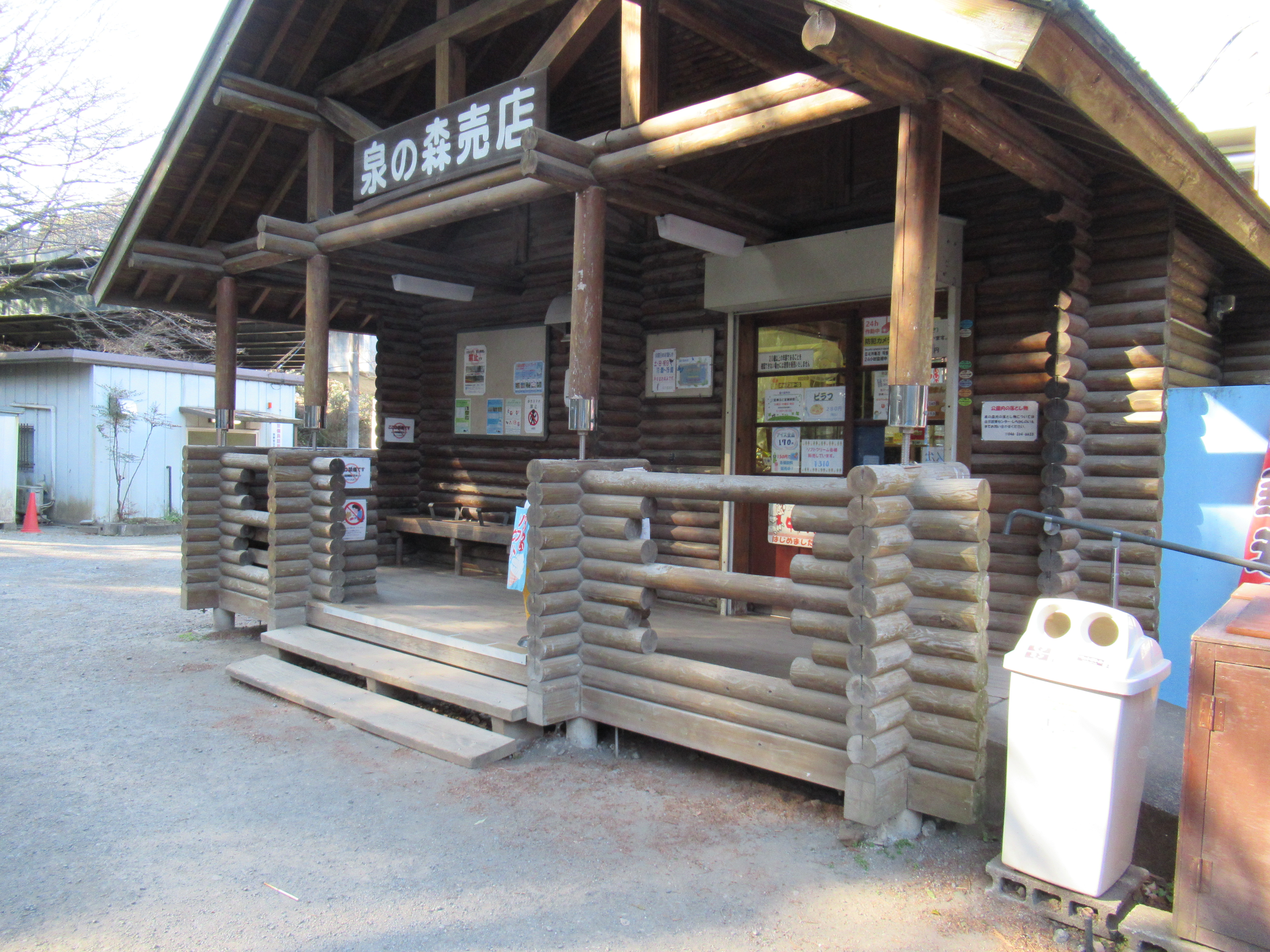
Southeast side of the 246 overpass starts with an area that has the administration cottage (“Shirakashi-no-ie”), a small shop, a police station, and a restored water mill. From the admin office, you can have a hardcopy of the map for the forest. The place also serves as a mini nature museum giving us information about the biosphere of the forest and the surrounding area. It also has the latest news from volunteer organizations that help the management of Izumi-no-mori Forest. If you’re living near there and interested in fieldworks for the forest and the stream, you can find info how to join them, etc. Oh, one important thing. Izumi-no-mori Forest equips toilets here and there, but the area surrounding the admin office has the largest numbers of it. Don’t miss your chance.

A shop and a police station

An admin-cum-museum cottage

Inside of the cottage is like this.

Water mill

In front of the admin area are landscaped streams that lead water from the source to Hikichi River. They have nice semi-paved promenades along the streams where lots of families have a leisurely walk for sunny weekends. The very end of this landscaped stream is a pond named “Bamboo-leaf oak Pond.” The place serves as a regulating reservoir to prevent flood from Hikichi River. It is allowed to fish there provided you don’t do lure fishing. During winter we can find lots of migratory winter birds floating on the pond. The place is famous for amateur photographers of wild birds. During winter they jostle each other for the best position for their perfect shot of mallards et al. The pond ends with a overflow dyke that is also the end of Izumi-no-mori Forest. Beyond the dyke is Hikichi River.

They built this nice suspension bridge
 over the landscaped stream.

Many people enjoyed the waterside.

And a row of photographers focusing on …

Eurasian Pigeon.

Great Cornmorants were also there.


The dyke which is the end of Izumi-no-mori Forest.

The southwest embankment of the dyke, there is a small forest of bamboo-leaf oaks (Quercus myrsinifolia). The place is considered to be a few remaining climax forest for Sagamino Plateau 相模野台地. Sagamino Plateau is a geological area sandwiched between Sagami River and Sakai River 境川 (; my post on January 28, 2022), ended around the border between Yamato and Fujisawa Cities. The plateau did not have good water sources for human consumption. During pre-industrialization people did farming on the Plateau, not rice cultivation, which was at that time an implicit sign of “poverty.” In the climate for Sagamino Plateau, the climax forest should be dominated by evergreen bamboo-leaf oak but people cut them off for their more convenient trees. They afforested their hills with sawtooth oaks, jolcham oaks, and coniferous trees. These oaks became good charcoal, the main fuel for people before imported oil dominated the economy. Their leaves supplied good compost for tobacco cultivation, the main cash crops during the period. Coniferous trees were sold for housing materials. Not many naturally climax forest remain now on Sagamino Plateau. The forest in Izumi-no-mori is a rare remnant of natural forest before people used intensively their land for their livelihood. (I won’t say it’s a virgin forest. Who knows if it has never experienced human intervention!) Kanagawa Prefecture designate the place as Prefecture’s Natural Treasure that should be protected “as is.”

Natural Treasure of the Prefecture

… looks ordinary, but …

Leave the dyke and walk the promenade along Hikichi River, we proceed under the flyover of Tomei Expressway, and enter “Fureai-no-mori ふれあいの森” which is a landscaped city park along Hikichi River. The end of Fureai-no-mori is almost the beginning of the main pedestrian way to Yamato Station. The other fine weekend when I took this route, the Forest, especially around the admin office to the Park and Yamato Station, welcomed many families and groups of friends. I even had a feel of “congestion.” The greenery and riverside are loved by locals quite a lot ... The reason why such seemingly ordinary forest of bamboo-leaf oaks is designated Natural Treasure is the area’s historical difficulty for the access of water sources. The scarcity of water, together with its location relatively near to Tokyo and Yokohama, made secretly unique the area of Sagamino Plateau and Hikichi River. Why does Hikichi River run through housing suburbs, and Naval Air Facility Atsugi? Why does the place not have many deep forests, compared even to Yokohama? And why does Hikichi River let microplastics float that much? Peaceful rows of family houses carry old, and contemporary, burdens, but in any case, we all love quiet strolls in the forest and along the river ... Oh, in some corners of Japan, people have started to discuss lawmaking to prohibit usage of astroturf, in order to stop microplastic contamination getting worse. The new chapter for Izumi-no-mori Forest and Hikichi River may start not before long.

To Fureai-no-mori

Under the Tomei Expressway is like this.

Brown-eared Bulbul were neatly drinking from Hikichi River.

Fureai-no-mori

There are signs showing us the direction to Yamato Station.

If you find environmental issues in Kanagawa Prefecture, please make a contact with Kanagawa Natural Environment Conservation Center 神奈川県自然環境保全センター

657 Nanasawa, Atsugi City, 243-0121
〒243-0121 厚木市七沢657
Phone: 046-248-0323

You can send an enquiry to them by clicking the bottom line of their homepage at http://www.pref.kanagawa.jp/div/1644/

Friday, February 3, 2023

Potemkin Villages: the voyage to the sea for Kanagawa’s microplastics


In my post for June 17th last year, I told you I was depressed during beachcombing in Shonan Beach 湘南海岸 to find lots of lots of microplastics. For those colorful artificial bits to reach there, there must be something carrying them to that point. It’s river, yeah. There are not many research done for the matter. But Prof. Yasuo Nihei of Tokyo University of Science is receiving grant from the City of Kawasaki (and the others) for checking microplastic contamination in Tama, Tsurumi and Sagami (and the other) rivers. The other day, he did a small seminar reporting his findings. He told us very curious results.

Obvious garbage in the beach. They are macroplastics.

According to him, Japan is floating in the area that is the most contaminated by microplastics on this planet. Hmmmmmm. He said in 2015’s study (Isobe et al, 2015) sea around our archipelago contains on average 3.74 bits of microplastics per 1 cubic meter water. From his study, average number of microplastic particles found from his sample rivers was 4.3 per 1 cubic meter. That could mean the major source of oceanic contamination around Japan would be Japanese rivers starting from Japanese forest. He also noticed when a basin for one river has higher population density and urbanization, the number of microplastic fleck found from the river is larger. Er, well, it stands to reason ... So, inevitably Tama and Tsurumi Rivers scores “not so well” regarding the level of contamination.

Could you figure out plastics out of these?
Microplastics are defined as 5mm or less in its size.

It’s disheartening news. During the 1960s and the 1970s, Tsurumi River was a poster child of Japanese river pollution. It was a flow of stinking sludge. No one wanted to go near. So, people built lots of sewage treatment plants along the river. It makes Tsurumi River without smell of transparent stream. Yeah, unfortunately from Tsurumi River Japanese fluvial sculpin (Cottus pollux Gunther, Japanese endemic freshwater fish) has not been found these 60 years. Maybe they were extinct there. But migratory fishes that love clean water, like Ayu sweet fish and eels, are now spotted frequently. Kids and families enjoy relaxing picnic along the bank of the river. Then, in seemingly transparent water, micro and nano plastics are floating in the worst density of the planet. *Sigh* Not only that, Prof. Nihei’s team found another curious thing.

Admitting, it’s not rare finding
plastic trash on river banks of
Tsurumi River …

According to Prof. Nihei, the density of microplastics are higher both in Tama and Tsurumi Rivers near fashionable Misashikosugui 武蔵小杉. In the same Kawasaki City, the area near Kurokawa Forest 黒川の森 (my post on December 2, 2022) where Tsurumi River nearing to its source, the contamination is negligible. That’s a sort of solace. Then, researchers analyzed the source material of microplastics. The things they have identified were (1) plastic fibers, (2) astroturf, (3) styrofoam, and (4) tarpaulin. Which do you think was the most common? Astroturf.

A spring pond in Kurokawa Forest,
one of the sources for Tsurumi River

The team also did the same research in Hikichi River 引地川 that runs through the middle of the Cities of Yamato 大和 and Fujisawa 藤沢 from Izumi Forest 泉の森 of Yamato City. Among the 4 rivers, Tama, Tsurumi, Sagami, and Hikichi Rivers which run within / along Kanagawa Prefecture, the most contaminated with microplastics was Hikichi River. And its source of contamination was definitely astroturf. Why? The area for Hikichi River is a typical suburb of megalopolis Tokyo. The place has lots of detached houses and small driving ranges for golfers. It is the area for dwindling Japanese middle classes. Maybe, just maybe I mean, people cut corners for their small garden and employ astroturf that does not need human maintenance, but look pretty all year round. Ditto for ordinary golfers who do not want to spend money at Hodogaya Country Club (which is the most prestigious golf club in Japan; my post on July 24, 2015). Such beautification contaminates the land, river, and the ocean ... It might be a parable from Japan where population is shrinking with Potemkin suburbs ...


If you find environmental issues in Kanagawa Prefecture, please make a contact with Kanagawa Natural Environment Conservation Center 神奈川県自然環境保全センター

657 Nanasawa, Atsugi City, 243-0121
〒243-0121 厚木市七沢657
Phone: 046-248-0323

You can send an enquiry to them by clicking the bottom line of their homepage at http://www.pref.kanagawa.jp/div/1644/

Friday, January 28, 2022

Always Look on the Bright Side of Life … Bird watching in Suburbia (and Pre-emergency Measures against COVID-19)


Pre-emergency measures again for Kanagawa … OK. Let’s visit a place where wings let the owner of the tool fly away from enclosed atmosphere … I mean, a place good for bird watching. In any case, winter is the best time in Japan to have a quiet conversation with wild birds. Many birds come to our relatively mild climate from far away (like Siberia) or snowing mountains. Deciduous trees have shed their leaves. Their boned boughs and branches stand out. It is easy for us to find birds parching on them. Besides, to enjoy bird watching, we have to go to open-sky space in nature, preferably solo, or maintain our conversation minimum. PERFECT activity for the pre-emergency against COVID-19! … Anyway, today I tell you my adventure of bird watching in suburbia. Yeah, the place we visit today is surrounded by sleepy residential area. Silver lining: the place is SLEEPY and I hope less dangerous to be infected by COVID … Let’s go to Flood-Control Park for Sakai River of Kanagawa Prefecture 神奈川県立境川遊水地公園.


Unfortunately, there is no bird here …

An exemplar attitude for
 Pre-emergency measures in Yokohama

The access to the Park is from Shonandai Station 湘南台駅. It’s a quiet terminal station for Odakyu Enoshima Line 小田急江ノ島線, Sotetsu Izumino Line 相鉄いずみ野線 and Yokohama Subway Blue Line 横浜市営地下鉄ブルーライン. Whichever commuter service you take, please leave the station from East Exit H. Just keep on walking straight. In no time, we get across Shonandai Park 湘南台公園 to enter pure housing area. In front of us are railway viaducts of Sotetsu and Yokohama Subway. From that point, our road goes down to the bank of Sakai River 境川. Simply go to the River and we are now at the northern tip of the Park, which is Imada Flood Control Pond 今田遊水地. It’s about 10 minutes relaxing walk from the Station. Welcome to the Flood Control Park of Sakai River!

Shonandai Station.
Please proceed to the bottom of this photo,
turn right at the end, then,

We’re here. Simply go ahead …

to cross this traffic light.
Over there is Shonanadai Park.

Across the Shonandai Park is standard residential area.
 Please keep on going to

find railway viaducts over there.
Yokohama Subway is coming to Shonandai Station.

Below the viaducts is an entrance to
 Flood-Control Park for Sakai River.

Imada Flood Control Pond 今田遊水地

In our neighborhood, the most famous flood-control park is Shin-Yokohama Park where Nissan Stadium stands (; my post on September 18, 2020.) Civil Engineering wise, the idea is the same for Flood Control Park for Sakai River. Sakai River, 52.1km, runs from the City of Machida 町田市, Tokyo, and pours into Sagami Bay 相模湾 at near Enoshima Island 江の島 (; my post on June 30, 2017.) When it departs from Tokyo, the eastern bank of the river is Yokohama for a while until just before it meets with Route #1. Eastern side of today’s Park is in the City of Yokohama, and the western portion is in the City of Fujisawa 藤沢. Almost entire basin of Sakai River now is very urban, mainly boring bed towns for downtown Tokyo and Yokohama. The process of development was housing first, then flood control … Hmmmmmmm, something was wrong, don’t you think? Sakai River runs down not so steep slope. It was flood prone. To build my-sweet-homes, people dug deep its riverbed and concreted banks of almost entire river. The suburbia around it is covered with paved roads and concreted structures. The idea backfired. Soils along Sakai River became under concrete almost entirely. It cannot absorb rainwater anymore. Water simply runs down to the River, which caused floods easily. It is a serious risk for offices and homes. People rethought the strategy to deal with the problem. The construction of flood-control park was started at the beginning of the 21st century. It works. Already in 2004, the flood-control system with overflow dykes in the Park prevented floods downstream. Good, good. When there is no storm, the Park consists of dotting flood control ponds, sports fields and nice mainly paved strolling path.


Overflow dyke in the Park

Along the dyke, the strolling path is for walkers and bikers.
 Lots of cyclists use this route in Fujisawa.

Flood gate from flood control pond, connecting to Sakai River

The majority of the path in the Park is barrier-free and flat. If you’re with strollers or wheelchairs, you will not have a serious problem to enjoy the park. The Park has ample parking space capable of welcoming more than 200 cars. 😉 The map of the Park is here. Basically we can start walking from whichever point we like. Having said that, I recommend visiting Information Center near the baseball field. If you understand Japanese, they have good panel exhibitions explaining the history and environment of the Park. Even if you’re challenged in Japanese, they have interesting display for fossils found during the construction works. These discoveries tell the place was the bottom of sea some 130 thousand years ago. Next to such presentations, there are aquariums showing the present dwellers of Sakai River and the ponds of the Park, including endangered Japanese ricefish. Oh, if you plan to use sports fields (with coin-operated showers) here, such as baseball ground, football field, athletics tracks, or tennis court, this is the office for making reservation. They also rent wheelchairs. For the detail, please check their HP here. Plus, this site tells us the existence of lunch delivery service to the Park from nearby cafes. 😊

Information Centre

Beautiful fossils …

Paths in the park are like this in general.

Baseball Field

In the middle of the park,
there is this elegant Saguimai Bridge
鷺舞橋,
which means “A bridge where herons dance.”

And at the foot of the bridge are toilets and showers.
Could you see the blue indicator on the wall?
It says in 2016 the flood water came this high by a typhoon.

It’s a relaxing waterfront not only for humans, but also for wildlife. Inside the Park Sakai River runs through and 3 flood control ponds-cum-biotopes exist along the River. Although I told you Sakai River basin is almost entirely concreted, the area around the Park preserves thin strips of agricultural land and petit forests … a sort of mass of trees beyond which from the other side we can recognize rows of housing roofs. For small wildlife, it is enough to thrive. The place is famous for its families of herons. Majorities of them stays here all year long. Migratory birds also make the Park their seasonal home. Young barn swallows have their “summer school” in the Park before they leave to Southeast Asia. In winter, many ducks come from Siberia to mate and nurse chicks. Information Center has monthly bird-watching program … Though due to Covid, it is suspended now. Let’s keep crossing our fingers for 2022 … for information of educational programs in the Park, please check here. The Center also leases binoculars for birdwatching, free of charge. Please bring your photo-ID to use the service.

Eurasian Teal

Lots of Great cormorant …

Eurasian coots are busy on shore for lunch.
It is said that their numbers are growing
these couple of years in our neighborhood.

A beautiful Grey heron

I don’t know why this Little egret kept up
 its left leg for a while and did not move at all …

I think it is Long-toed stint.

I was a sort of amazed to know these biotopes were man-made. In information Center, we can see photos of the area before the park development. It took less than 20 years to receive these wild bird families. Wow. Actually, not only professional landscapers, but volunteers, including college kids from nearby campuses, regularly work to maintain the biotopes in the Park. In the end these ponds are part of the flood controlling system. We need to make them alive in order to maintain safe suburbia … Something very typical nature-human relationship in our neighborhood of Yokohama, I think.

I could not identify the guy on the right corner …
Heeeeelp!


If you find environmental issues in Flood-Control Park for Sakai River of Kanagawa Prefecture 神奈川県立境川遊水地公園, please make a contact with

Information Center, Flood-Control Park for Sakai River of Kanagawa Prefecture
神奈川県立境川遊水地公園情報センター
5-5 Shimoiida-cho, Izumi Ward, Yokohama, 245-0017
〒245-0017 横浜市泉区下飯田町5-5
Phone: 045-805-0223
FAX: 045-805-3917