
Last year, we had several monster typhoons which caused floods and landslides in Metropolitan Tokyo area. One of such was Typhoon Hagibis that let Japanese government to decide flood the sports park surrounding the Nissan Stadium, aka Shinyokohama Park 新横浜公園, for October 13th Rugby World Cup match between Scotland and Japan. The access to the anti-flood facility of Shinyokohama Park called Tsurumi River Multipurpose Retarding Basin 鶴見川多目的遊水地 is, of course, off-limit for non-permit holders. This summer, I had a chance to enter the restricted area and to join a nature observation session there. It was damned hot and humid day. We donned face asks. But the flood control area was only for us, i.e., no congestion at all, winds over Tsurumi River 鶴見川 was comfortable, and water creatures were cute. Today, I report you my adventure with nature thriving on the man-made flood control system in Shinyokohama Park.
 |
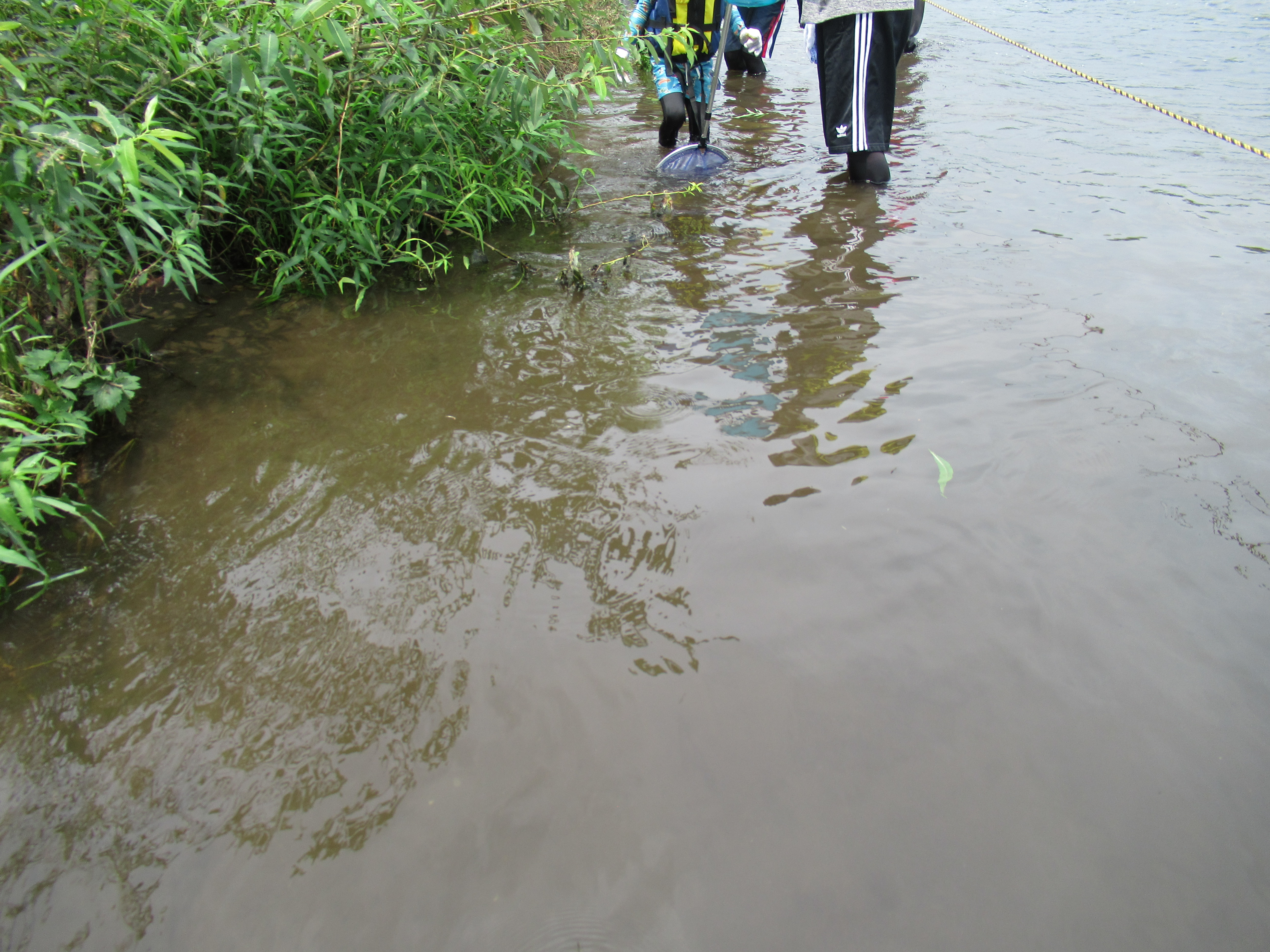
| The entire scenery of this photo was flooded last October. |
As I mentioned in my post on February 21 this year, the flood control mechanism in Shinyokohama Park is one of the bests (and the most expensives) in Japan. Since its opening in 2003, Shinyokohama Park was operated as a flood buffer 21 times, or in total of 240 hours. People from Tsurumi River Watershed Center 鶴見川流域センター explained us the flood control is by the Ministry of Land, Infrastructure and Transport of Japan, and the management of sports park is done by the City. After the place was used as a flood pond, the cleaning of the area to restore the facility is by the City of Yokohama. “Last year when the Rugby World Cup was held, the City spent 60 million yen (USD 600 thousand) to clean up the place after the flood.” As Tsurumi River meanders from a small hill in Machida City (ASL 170m) to Tokyo Bay, it wears Tama Hills made of sand and mud. Its water is always muddy, unlike the neighboring Tama River. When it floods it carries tons of mud to the basin. So, “The cost of cleaning up depends on the amount of mud remained on the park. Last year’s amount was for 60-million-yen expenditure. In the City of Yokohama, this was the last remaining flat public land of this size. The municipality accepted the deal.” I see.
 |
| Maintaining this scenery costs money. |
Aside from its local coordination mechanisms and the overall design as an anti-flood reservoir, it was interesting to see on site the detail of Tsurumi River Multipurpose Retarding Basin. The off-limit area of Shinyokohama Park starts from an elongated pond in the north that acts as a stilling basin when the flood happens. In summer it is covered by Trapa japonica. “We cleaned the pond few years ago, then the plant came out naturally.” The person from the Center said. That’s interesting. Although the Park is surrounded completely by commercial, industrial, and housing buildings, if preparation is OK, nature comes back almost automatically. The north of the pond is 400m overflow dyke, strictly off-limit for non-permit holders. The levee of Tsurumi River for Shinyokohama Park is Prefectural Road #13 that has bus stops for Nissan Stadium. The overflow dyke is 3m lower than the levee so that when Tsurumi River is flooding, 400m wide overflow naturally occurs here. In normal times, the overflow dyke is very wide-open strolling place for occasional visitors like us, or for a helicopter to land. It’s an artificial structure whose slope is constructed with many gabions of wire cage. Each unit of gabion is staffed with natural stones so that when the area is inundated the water can seep in the cage. In this way, the power of flow is dampened, and the sports park can be opened just by cleaning up the mud. Moreover, the cage becomes home for many kinds of creatures, animal and vegetable. In mid-summer, walking on the overflow dyke is like strolling a wide paved road sandwiched by natural gentle slopes with lots of grass and insects. “We mow the area once or so a year.” I guess it also helps for the area to increase the biodiversity as it allows the floor to receive enough sunshine. Nature can grow in the middle of city on such artificial arrangement.
 |
| The pond in the north of
the sports park. It is shielded by the wire fence. We can go without permit near to the fence. |
 |
| The pond in summer is covered by Trapa japonica. Grey helons make the place home. It means, the pond has lots of foods for the birds. |
 |
| The entrance to the overflow dyke is locked securely. |
 |
| From the entrance on the
levee, it is going down 3m to the dyke. |
 |
| The 400m long overflow
dyke of Tsurumi River Multipurpose Retarding Basin |
 |
| Both east and west ends
of the dyke have this water gage pole that send real time info 24/7 to the control center of the river. It can measure the amount and speed of water flow with various electromagnetic waves. “Please do not enter the zebra zone, NEVER. It interprets your height as the water depth, and your movement as the speed of the overflow. The emergency scramble will be issued.” |
 |
| The entire slope of the dyke is constructed with such gabions. |
 |
| The northside of the
dyke to Tsurumi River was received mowing when we’ve been there in August. |
 |
| And the place has a
family toilet for wild racoon dogs. It seems to me the restricted area is a safe place for wild animals. The poop was fresh. |
 |
| The large sign on the
dyke visible from helicopters when they need it. |
 |
| After flood, water in the park is returned to the river from this gate. |
In Tsurumi River at the corner of Shinyokohama Park, there is a small weir named Kozukue-Seki 小机堰. It is a mobile weir that was to flood rice paddies before. Now its main function is completely retired, but it acts as a small waterfall for the River that runs relatively flat plane. The bubbling caused by the cascade incorporates oxygen from the air in the water. Especially during summer, it creates an ideal condition for water creatures to ride over heatwave. Tsurumi River separated from Shinyokohama Park by an artificial dyke covered by growing natural environment has many kinds of fishes. Just for 15 minutes playing with small fishing nets on the riverbank, we could capture several kinds of aquatic lives. Thanks to Kozukue-Seki, the fishes of brackish water can come up to this point from Tokyo Bay. Some decided to stay here. Flathead grey mullets are making the area their home. Crabs are more mobile, the people from the Tsurumi River Watershed Center told us. According to them, Japanese mitten crabs are identified in almost entire Tsurumi River, although they are not as large as we can find in Chinese restaurants. Yet fishes in Shinyokohama Park were far larger than those we can find in Yadoriki Stream 寄沢. I realized that’s the difference between river basin and mountainous valley. Yeah, Shinyokohama Park is a typical urban sports park. As Tsurumi River gathers sewage of millions of people although they undergo intensive advanced treatment, the river’s BOD has still rooms of improvement. But Tsurumi River secretly becomes home for so many living creatures that have voluntarily immigrated to this artificial place. That’s something.
 |
| Kozukue-seki |
 |
| A flathead grey mullet easily captured |
 |
| We did a bit of fishing … |
 |
| Dragonfly nymphs of three kinds: of Melligomphus viridicostus, Sieboldius albardae, and Boyeria maclachlani. |
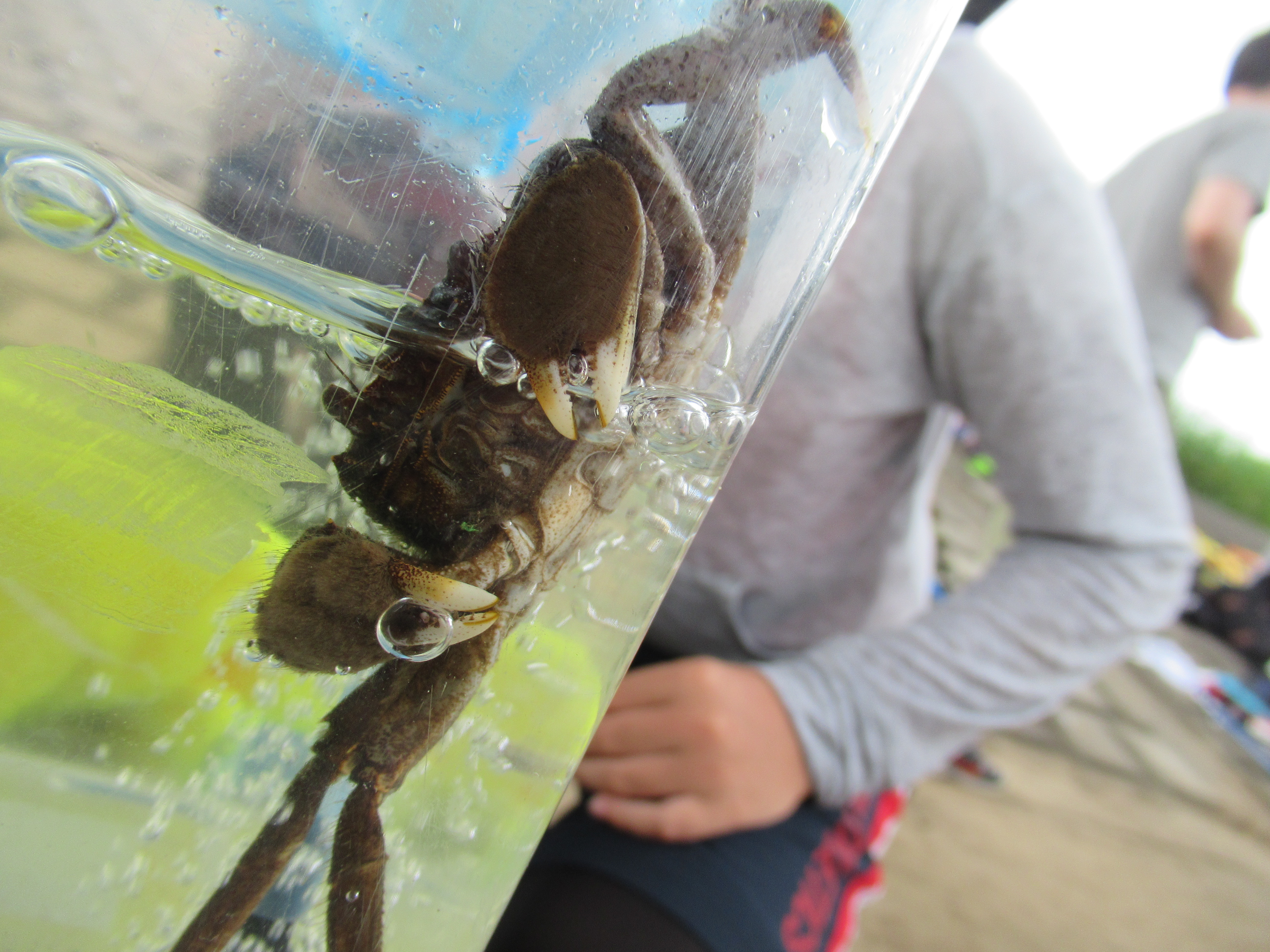 |
| Hairly Japanese mitten crab |
 |
| Pacific redfin and pale chub. Looked from front, they look very cute. 😊 |
 |
| Tsurumi River has many
kinds of Gobiodei as well. |
So, now in Japan the time of typhoons has come again, and we may see another inundation of Shinyokohama Park. Let’s prepare for the emergency. This year, as we’re with COVID-19, Japanese DRR offices recommend to pack additional things for your emergency backpack: face masks, medical thermometer, personal alcohol wipes, soaps, paper towels, disposable plastic gloves, garbage bags, water, comfy shoes, and portable toilet. For general info to prepare for natural disasters, please check my blog on February 28, 2020. Recently, Government of Japan decided to merge Hinankankoku 避難勧告 “Recommendation to evacuate” and Hinanshiji (Kinkyu) 避難指示(緊急)”Immediate evacuation order” as “Evacuation order.” They also say when you can find the place to evacuate without being in a crowded, say, school gym, please choose that place instead of mechanically go to the designated evacuation center. Your friend’s home may be safer when we consider the risk of COVID, isn’t it?
 |
| X-band radar the
Ministry deploys next to the Tsurumi River Watershed Center. It is capable of spotting rapid beginning of small local rain cloud. The Ministry is expanding the nation-wide coverage of such towers. The rapid warning issued from the radar can be found from here 24/7. From this site, we can also download the smartphone app to receive the info. |
When you find issues
in Tsurumi River, please make a contact with
Tsurumi River Watershed Center 鶴見川流域センター
Phone: 045-475-1998
FAX: 045-475-1999
https://www.ktr.mlit.go.jp/keihin/keihin00490.html
Keihin River Office,
Kanto Development Bureau
Ministry of Land,
Infrastructure and Transport of Japan
国土交通省 関東地方整備局 京浜河川事務所
2-18-1 Tsurumi-chuoh,
Tsurumi Ward, Yokohama, 230-0051
〒230-0051 神奈川県横浜市鶴見区鶴見中央2-18-1
Phone: 045-503-4000
No comments:
Post a Comment