
In our cherry blossoms ridge walk of Mt. Takao area, there are only 4 points that require us up steep slopes. The rest is relatively flat or going down. The first climb is to Mt. Jimba 陣馬山 ASL 855m, for roughly 1 hour exercise. The other 3 points are all for about 10 minutes going up before the remaining peaks in our itinerary. Now, we are nearing to one of them, i.e., the top of Mt. Kagenobu 景信山 ASL 727.3m. After we walk for 70 minutes or so from Sokozawa Pass 底沢峠, please be ready and endure the steep but short climb to the peak. After passing the bush of sasa-bamboos (; I warned you to wear long pants for this hike!), we reach to the open space at the top of Mt. Kagenobu. Here, the space is wide-open and there is a café with lots of picnic benches. The proprietor of the café allows hikers who sit far-corners of the café to use the space for cooking by ourselves. This is one of two locations in this hike where we can fire portable burners for lunch. Mind you, this arrangement is purely from kindness of the café. Never start cooking your soup in front of the café hut or sharing your meal with strangers you’ve met there; it can be a crime of obstruction of business, you know. Anyway, another nice thing at the top of Mt. Kagenobu is, A-Spectacular-View to the direction of downtown Tokyo. We look down pink dots of cherry blossoms in the eastern slope of Kagenobu, and over there, if weather permits, a silhouette of Tokyo Skytree. The feeling of wide-open freedom is overwhelming ...
 |
| To the top of Mt. Kagenobu |
 |
| Nearly there … |
 |
| Signpost for the top of Mt. Kagenobu |
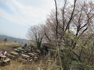 |
| Lots of seating space for café |
 |
| The
café is under the canopy of cherry trees. I think if you start cooking here, the proprietor of the café comes to warn you … |
 |
| Mmmmmmmmmmmmmmmmmmm |
To return to the soft ridgeway walk, we briefly climbing down a steep slope. In our itinerary, the area around the peak of Mt. Kagenobu is the most remote area from towns. Inevitably, the trekking path here can resemble more for deep Tanzawa mountains 丹沢, rather than that for the area around the peak of Mt. Takao. People you meet here could be more regulars for mountaineering. Having said that, it won’t take more than 40 minutes for us to reach to Kobotoke Pass 小仏峠 from Mt. Kagenobu. It seems to me people who manage Meiji Forest Takao Quasi-national Park 明治の森高尾国定公園 are now engaging cleaning up Kobotoke Pass area. Compared with my adventure in 2017 around Kobotoke Pass, the picnic benches are cleaner. The vegetation around Kobotoke Pass is mainly afforested conifers. But once we proceed up to the direction of Mt. Shiroyama 城山, and start looking down Lake Sagami 相模湖 to the west, the broad-leaved trees regain the dominance of the scene. My expectation for cherry blossoms were once again growing. In about 30 minutes from Kobotoke Pass, after 10 minutes or so climb, we reach to the top of Mt. Shiroyama.
 |
| Going down to Kobotoke Pass |
 |
| I’ve
met a lizard, Plestiodon finitimus. Coming out from hibernation! |
 |
| Flower
field for violets continues. This is Viola eizanensis. |
 |
| Kobotoke
Pass. Cherry blossoms and wild azalea say hello to us. 😊 |
 |
| Beyond
Kobotoke Pass, we come to a viewing point for Lake Sagami. |
 |
| Pink smoke in a forest, before Mt. Shiroyama |
 |
| To the peak of Mt. Shiroyama |
The top of Mt. Shiroyama, ASL 670.4m, also has a café and lots of picnic benches. Here, provided we behave politely as we’ve done at Mt. Kagenobu, we can use our stove for cooking. It is also thanks to the kindness of café owner. You may brew your coffee here and enjoy the view not only to the east but also to the west of our ridge way. To the east is again for the downtown Tokyo. To the west is Tanzawa mountains and Mt. Fuji 富士山. Moreover, from here big cherry trees start showing off their pink flowers just next to us, not as pink clouds within thick forest. You may be welcomed by slow showers of pink petals while enjoying aroma of hot coffee and cookies … er, if you have enough time left before dusk, I mean. Anyway, from here to the cable car station, there are lots of cherry trees standing along the hiking course which is THE main street for Mt. Takao Hiking. Keeping in mind the time for the last cable car service (at 18:00), let’s proceed this “cherry tree-lined avenue” to the top of Mt. Takao, ASL 599.3m. Depending on your way of enjoying cherry blossoms, it may take more than one hour from Mt. Shiroyama to Mt. Takao. Again, the last 10 or so minutes to the paved top of Mt. Takao is steep slope (and steps). If you’re not accustomed to mountain walk, the last “attack” here could be demanding especially after 6 or so hours of hiking. Please persevere. From the top of Mt. Takao where the Visitor Center locates, we go down to the cable car station via Yakuoin Temple 薬王院 (; my post on December 15, 2017) the scenery is more of a city park where large cherry trees stand at strategically chosen points. You may see high-heeled ladies in skirts strolling. Phew. Congratulations! You’ve completed your Mt. Takao ridge hike, with secretly famous cherry blossoms!
 |
| The
café for Mt. Shiroyama. Lots of seating space with flowers! |
 |
| To Mt. Takao, cherry blossoms lined main street. |


 |
| Going
up to the top of the mountain … er, well, slightly fed up with pink? |
 |
| to be
continued … come to think of it, all of these cherry trees are not planted, but wild. This is something, don’t you think? |

 |
| Nearly
there … and I think these cherry trees were planted. |
 |
| The cherry blossoms at Yakuoin Temple |
p.s. Mt. Takao Cable Car service runs over the slope of 31’18”, the steepest for cable cars in Japan. FYI.

The contact address for the office in charge of Meiji Forest Takao Quasi-national Park 明治の森高尾国定公園 is
Bureau of Environment, Tokyo Metropolitan Government 東京都環境局
2-8-1 Nishi-Shinjuku, Shinjuku-ku, Tokyo, 163-8001
Phone: 03-5388-3539,
FAX: 03-5388-1379
S0000618@section.metro.tokyo.jp
No comments:
Post a Comment