Showing posts with label Forestry Roads. Show all posts

Friday, December 3, 2021

Let’s Do Nature Observation; Mikurube Forestry Road, Part 2 三廻部林道 2


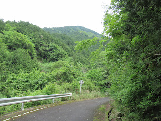
The forest along Mikurube Forestry Road 三廻部林道 is designated as a water source forest by Kanagawa Prefecture, i.e. protected for nature conservation. My impression is, half the vegetation is afforested conifers and another half is of broad-leaved trees which is a mixture of evergreens and deciduous kinds. The route is paved for cars. The surface of the road is sometimes covered by fallen leaves or the like, but at least as of November 2021 there is no disruption by landslides. Compared with the other forestry roads in Tanzawa 丹沢, Mikurube Forestry Road is relatively less steep. Almost entire route has crash barriers. In short, your itinerary with Mikurbe Road is a nice mountain stroll on a paved way. Having said that, as this is a road running on a surface of sharp Tanzawa Mountains, the valleys beyond guard rail are precipitous and deep. If you’re with your adventurous kids, you’d better be watchful especially when they try to cross the barrier.

 When we walk from
Entrance to Omote-Tanzawa Citizen Forest Bus Stop
  
表丹沢県民の森入口,
we first find the sign for the beginning
 of Mikurube Forestry Road, then,
there is a sign at the junction
 with Kami-Hadano Forestry Road
上秦野林道
(which is to Omote-Tanzawa Citizen Forest)
 showing the direction of Mikurube Road.
 Here, we take the road on our left.

The gate is after the above signpost.
 Could you see it over there at the end of this photo?

We can walk the route in this condition.

As this is a quiet paved road, it’s easy doing plant observation party along Mikurube Road. The trees we often encounter in our walk may tell typical geological condition of Tanzawa. Ainus pendula, Euptelea polyandra Soeb. Et Zucc., and Japanese walnut (Jaglans mandshurica) are very common. Ainus pendula is a pioneer plant thriving on a scree slope where they can enjoy lots of sunshine with a smaller number of competitors. Euptelea polyandra and Japanese walnut love humid banks of streams. Such trees suggest fragile soil of Tanzawa with lots of rains. Mountainside of the Mikurube Forestry Road is often treated against rockfall, but mantle vegetation-like scenery covers man-made stonewalls. Solanum lyratum shows off their bright red berries in fall. Jack-in-the-pulpits are here and there in early summer. If you love nature, you’ll enjoy your weekend here searching for interesting things.

 A scenery of forest along Mikurube Forestry Road

Euptelea polyandra, early summer

Stephanandra incisa is
dangling from the slope, early summer

Large Caesalpinia sepiaria var. japonica,
 coiling itself from the bottom of the valley

Youngia denticulata,
another pioneer plant for scree slope and
 the last flower before Christmas

Rhus sylvestris began
 turning red in early November.

Observing Mt. Toh 塔ノ岳 (ASL 1491m) from Mikurube Forestry Road.
 Could you figure out the front of this photo shows clear-cut logging?
 The afforested area needs tending by foresters to maintain biodiversity.
 Humans harvest logs from such part, carry the logs via the forestry road.

Wild Japanese lentian in Mikurube Forestry Road

Actually, not only plants, but also animals we meet in Mikurube Forestry Road. When a quiet mountainous road is easy for humans to walk, so as for animals. Here, finding their footprints is easy on the road-side slopes. During spring to early summer, we hear tweets of Himalayan cuckoo or Blue-and-white flycatcher. The other day, when we finished our lunch and prepared to resume our walk, we noticed our rest was observed by a curious Japanese serow situated himself (er, I though it was “he”) on a slope just above our heads. If you’re seeking a chance to watch spider cubs helter-skelter in all directions, you may poke one of kindergartens of 8-legged kids on a moss-covered crash barrier. It’s purely a fun!


Hi there.


Whichever gate you choose to start walking Mikurube Forestry Road, it’s one way route in quiet forest. As long as you keep yourself on a paved road, you’ll never lose the way. Admitting, to enjoy this road we have problems for the access to the entrance. But, if you have a chance, especially with kids and illustrated reference books for fields, please try. I bet you can satisfy you and your family’s appetite for nature observation in Tanzawa Mountains. Ainus pendula and Euptelea polyandra Soeb. Et Zucc. flower early in spring. In this world of global warming, we may find their flowers in February, or even in January …


If you find environmental issues in Kanagawa Prefecture, please make a contact with Kanagawa Natural Environment Conservation Center 神奈川県自然環境保全センター

657 Nanasawa, Atsugi City, 243-0121
〒243-0121 厚木市七沢657 
Phone: 046-248-0323

Friday, November 26, 2021

Hiking in deep Tanzawa along the pavement; Mikurube Forestry Road, Part 1 三廻部林道 1

Abraxas miranda

Japanese mountainous areas have two kinds of roads. One is the ordinary route as in towns and cities for standard travelers of day-to-day activities, like shopping, daily commuting for business/school, having fun, etc. Another is so-called forestry road. They are mainly for the necessities of business of forestry. They run windingly in deep mountains. Normally they do not have bus stop. Their design is for foresters in pickup trucks. It does not care for family cars to run smoothly. They may be paved but once some disturbance, like landslides, happens, municipalities often are not in a hurry to repair. Encountering gravel rocks in a twisted forestry road is common. Sometimes, the access to that road is limited for permit holders, such as the forestry road in Yadoriki Water Source Forest やどりき水源林. The good thing for such forestry road is, as this is a very specialized facility, using it we can hike quiet mountain areas without encountering much crowd. Yeah, cars can come, maybe just once during your day walk. It’s not much. As this is a paved way, the novices of hiking can try mountain areas with relative ease. Today, I introduce you one such road in Yadoriki Community 寄. That’s Mikurube Forestry Road 三廻部林道.

Pretty Deutzia scabra,
May 2021 in Mikurube Forestry Road

Mikurube Forestry Road connects Omote Tanzawa Citizen Forest 表丹沢県民の森 (; my post on November 10th and 17th, 2017) and Yadoriki Community. Actually, Mikurube Forestry Road crosses the route for climbing Mt. Nabewari 鍋割山 (ASL 1272.4m). You may encounter aficionados to/from Mt. Nabewari using Mikurube Road, instead of the standard route, to the bus stop. Hikers often use one’s own car for the Citizen Forest and Mt. Nabewari, parking it near the Citizen Forest. Though the Prefecture has the right to tow cars without permission to enter this far. In the end the road is for foresters, you remember? Both at Omote Tanzawa Citizen Forest side and at Yadoriki side, the entrance to Mikurube Forestry Road has a locked gate. Only permission holding cars/bikes can run here. In contrast, the gate is not for pedestrians. We can pass through the points just by crossing the gate from the gap. Unless there is a forester doing his/her business along Mikurube Forestry Road, it’s a relaxing hiking route in deep Omote Tanzawa. Bonus: unlike the forestry roads running from, say, Okura Bus Stop 大倉 in Hadano City 秦野市, not many people use this route. You can enjoy your quiet one-day hike in Mikurube Road.

Tricyrtis hirta near the gate for Citizen Forest side

The name “Mikurube” is very rare in Japanese. This site says the naming was due to a rather strange landlord of the area who insisted to call his Buddhist temple Mikurube in the 15th century. In short, no one knows why the place is called like this. As the area is a part of Tanzawa Mountains 丹沢, we Kanagawa Forest Instructors suspect there could be a secret meaning from Shugendoh 修験道, Japanese mountain ascetism. From the entrance of Citizen Forest side to Mikurube Pass 三廻部峠, which is the half of Mikurube Forestry Road, the road runs in Mikurube Township. From Mikurube Pass to another gate near Miroku Camp Field ミロクキャンプ場, the route goes through Yadoriki Township. For both townships, no human settlement is there along Mikurube Forestry Road.

Around Mikurube Pass, we can find
Viburnum plicatum var. tomentosum here and there.
 It has cute white flowers just for a week
 in late May to early June.

The entire length of the road is about 6.6km, and the difference in elevation is about 250m, not much in any case. Though from the nearest bus stops to both entrances, it’s about 15-45 minutes’ walk. I guess the total mileage for hiking would be about 12km. If you enter the Road from the Citizen Forest side, please take community bus service named “Kami-chan Goh, Mikurube Line 上ちゃん号 みくるべ線” (timetable here) from Odakyu Shibusawa Station 渋沢駅. Please get off the bus at “The Entrance to Omote-Tanzawa Citizen Forest” Stop 表丹沢県民の森入口, and walk for approx. 45 min to the entrance. Er … this service is weekdays only. For weekends, we have to use Okura Bus Terminal 大倉ターミナル (; timetable from Shibusawa Station is here) and take the route to the Citizen Forest I reported in my posts in 2017. You see how remote the place is.

Also near the gate of Citizen Forest side,
Aster ageratoides ssp. Leiophyllus.
Although the road is paved,
we can find many wildflowers along Mikurube Forestry Road.

Another side, the entrance near the Miroku Camp Field is about 15-20 minutes’ walk from Yadoriki Bus Terminal of Fujikyu Bus from Shin-Matsuda Station 新松田駅 (timetable here). Also, Miroku Camp Field has parking spaces for campers. It is a secretly VERY popular camping site with full-facility. Especially from the beginning of COVID-19 pandemic, the proprietor allows only 10 families a day for camping … ideal to have a break from pandemic, isn’t it? If you’re lucky enough able to reserve a camping space at Miroku Camp Field with your kids, it one of the options for your holiday menu enjoying one day hike back and forth along Mikurube Forestry Road. Next week, I’ll tell you how actually the Mikurube Forestry Road was this year. Please stay tuned!

Cute flowers of Alangium platanifolium var. trilobum,
found along Mikurube Road, early summer, 2021.

If you find environmental issues in Kanagawa Prefecture, please make a contact with Kanagawa Natural Environment Conservation Center 神奈川県自然環境保全センター

657 Nanasawa, Atsugi City, 243-0121
〒243-0121 厚木市七沢657
Phone: 046-248-0323

Thursday, March 18, 2021

Quiet conqueror: Yadoriki Water Source Forest, early spring 2021 やどりき水源林

Euptelea polyandra in March 2021 for Yadoriki Forest


The last time I’ve been to Yadoriki Water Source Forest やどりき水源林 was October 2020. The place was under heavy reconstruction from the destruction by typhoons in 2019. Early this month, I’ve returned there. The works are still on-going, but several parts are open to hikers.

Japanese green alder (Alnus firma)
 in March 2021 for Yadoriki Forest

The prefecture has almost completed the repair works for the forestry road from the gate of Water Source Forest. We can walk a paved road almost to the end of the former route. The collapsed section is detoured by a new cutting through the western slope of Mt. Nabewari 鍋割山 (ASL 1272.4m). The debris of landslides 2 years ago still remain, but they definitely become a small part of the course. I think finally families with kids can walk there now. Though, we forest instructors have recognized that the prefecture, i.e. the landlord, does not intend to recover the pavement fully that before reached to the starting point to the trail to Ameyama Pass 雨山峠 (ASL 957m). Anyway, there is undeniably an improvement.

The collapsed part of the previous route is detoured.

The work is still going on …

Yadoriki Stream 寄沢, which caused flash floods and debris flows in 2019, is undergoing a substantial intervention. The Prefectural Office flattened the riverbed with heavy machinery and digging artificial water way in the middle. We seriously doubted how long such synthetic river can last if another monster typhoon hits the area again … In 2019, the Open Space near toilets suffered heavy erosion to be reduced in half. The place is still off-limit. We hope the site becomes accessible by summer holiday. But … could we find a place for kids to play with water, I wonder …?


This is the flattened riverbed.
 We cannot see the stream from this point,
 but a fissure at the foot of these destroyed logs
 is artificially dug water way.

Woooooooow.
 The stream looks like a road now …
 the construction work is going-on.

The afforestation expanded on the western slope of Yadoriki Stream is receiving an intense forestry by thinning cedars and cypresses. The prefecture told us the place is accessible only for professional foresters who contracted the work from the Office. In 2019, Yadoriki Stream was flooded with broken and uprooted afforested trees. So, doing professional forestry up there to stabilize the slope certainly has a good reason. They say the work will continue at least until summer this year. We will be able to have a quiet autumn walk in Hadano Forestry Road 秦野林道 this year …

The trolley line for forestry to the western slope is
 fully operational now.

We found lots of Astraeus sp. as well.
 They love gravelly place so that encountering them
 in Yadoriki of under-construction may not be surprising.

Despite of massive civil engineering, I personally find the nature of Yadoriki Forest is recovering strongly. After the typhoons in 2019, I felt sad to find many decimated points where before beautiful mosses secretly but cheerfully sprouted their capsule to procreate. Now they are coming back, if not fully. Impressive. In Chinese character, mosses are written as 苔. It’s a hieroglyph. The top part which looks like a hat means “row of grasses.” The middle symbolizes “plow”, and the bottom is “mouth.” When a farmer starts his/her work in the spring, the first thing s/he normally does is plowing the ground like opening the mouth of soil. So, the Chinese character for mosses means “it’s the beginning of vegetation.” Yeah. Yadoriki Water Source Forest was covered with mountain debris two years ago. Aside from the endeavor of humans restoring the place, tiny mosses may be quietly taking a lead for the recovery of the forest ... Petit conquerors!

I think, they are Palamocladium leskeoides.
 Such delicate apparitions of mosses were
 gone after monster typhoons of 2019
 … Now, they’re back!

The beloved Racomitrium japonicum are recovering in Yadoriki.
 Hurrah!

If you find environmental issues in Kanagawa Prefecture, please make a contact with Kanagawa Natural Environment Conservation Center 神奈川県自然環境保全センター

657 Nanasawa, Atsugi City, 243-0121
〒243-0121 厚木市七沢657
Phone: 046-248-0323

You can send an enquiry to them by clicking the bottom line of their homepage at http://www.pref.kanagawa.jp/div/1644/